Loading...
Pubblicazioni Scientifiche
Filtri di ricerca 182 risultati
Pubblicazioni per anno
Forest structure and understory functional diversity at multiple scales: The importance of median tree height
de Benedictis
,
Luciano Ludovico Maria
,
Chelli
,
Stefano
,
Zhu
,
Zhengxue
,
Cervellini
,
Marco
,
Canullo
,
R.
,
Chianucci
,
Francesco
,
Puletti
,
Nicola
,
Tsakalos
,
James L.
,
Bartha
,
Sándor
,
Campetella
,
Giandiego

Spectral heterogeneity from the spaceborne imaging spectrometer EnMAP reveals biodiversity patterns in forest ecosystems
Torresani
,
Michele
,
Rossi
,
Christian
,
Mina
,
Marco
,
Menegaldo
,
Irene
,
Cappuccio
,
Matteo
,
Perrone
,
Michela
,
Hakkenberg
,
Christopher R.
,
Rocchini
,
Duccio
,
Puletti
,
Nicola
,
Stendardi
,
Laura
,
Montagnani
,
Leonardo
,
Tognetti
,
Roberto
Mostra abstract
The Spectral Variation Hypothesis (SVH) proposes that spectral heterogeneity (SH), derived from optical data, can serve as a proxy for estimating biodiversity. In this study, we tested the SVH across 42 forest plots in the Italian Alps using imaging spectroscopy data from the EnMAP satellite. We investigated the relationship between SH—quantified using two different metrics, Rao's Q and the coefficient of variation (CV)—and tree species diversity (using Shannon's H index and species richness). We applied three levels of spectral analysis: (1) SH calculated for each individual EnMAP band; (2) SH aggregated across broader spectral ranges (Visible -VIS-, Near Infrared -NIR-, and Shortwave Infrared -SWIR-) and (3) SH derived from vegetation indices (VIs). These analyses were performed under three spatial approaches: (A) a normal approach assigning equal weight to all four EnMAP pixels intersecting a plot; (B) a weighted approach based on the proportional overlap of each pixel with the plot area; and (C) a weighted canopy cover (CC)>70% approach, which included only plots with CC greater than 70% as derived from airborne laser scanning (ALS) LiDAR data. Weak to moderate correlations were observed when SH was derived from single bands, with the strongest relationships in the NIR (R<sup>2</sup> approaching 0.4), followed by the VIS and SWIR regions. A similar trend emerged when SH was aggregated across broader spectral ranges, with the highest correlations again found in the NIR (R<sup>2</sup> up to 0.35). In contrast, lower R<sup>2</sup> values were obtained when SH was computed from specific VIs. The weighted approaches, especially when restricted to plots with CC >70%, consistently yielded higher R<sup>2</sup> values than the equal-weight approach in all three the spectral analysis. Results were consistent across both SH metrics (Rao's Q and CV), with stronger correlations when species richness was used as the biodiversity metric. This work highlights how EnMAP hyperspectral data, despite inherent constraints, can provide valuable insights into forest biodiversity monitoring. © 2025 The Author(s)

CrowNet: a trail-camera canopy monitoring system
Chianucci
,
Francesco
,
Lenzi
,
Alice
,
Minari
,
Emma
,
Guasti
,
Matteo
,
Gisondi
,
Silvia
,
Gonnelli
,
Marco
,
Innocenti
,
Simone
,
Ferrara
,
Carlotta
,
Campanaro
,
Alessandro
,
Ciampelli
,
Paola
,
Cutini
,
Andrea
,
Puletti
,
Nicola
Mostra abstract
Continuous monitoring of forest canopy structure and phenology is pivotal for the assessment of ecosystem responses to environmental variability and changes. The present study evaluated the use of repeat digital trail cameras as a low-cost, flexible, and accessible in situ monitoring solution for quantifying daily canopy attributes, including effective leaf area index (Le) and canopy cover. A trial camera monitoring network (CrowNet) was established encompassing 20 forest stands in Italy, under different management and environmental conditions, resulting in over 44,000 daily images collected over three years. We demonstrated that taking the mean daily canopy attribute allowed to obtain smooth time series from trail cameras, from which phenological transition dates can be inferred. Daily canopy attributes were validated against manual digital cover photography measurement. To further explore the applicability of this monitoring solution, we performed a comparison between daily Le time series derived from a subset of trail cameras located in beech forests and data collected by multitemporal UAV LiDAR. Results demonstrated the close agreement between the two methods across the entire phenological period (start and end of season). We also illustrated use of continuous trail camera estimates to calibrate a vegetation index (NDVI) to infer leaf area and canopy cover from optical multi-temporal UAV data. We further investigated use of trail camera to detect species-specific differences in tree phenology from time series acquired in a mixed oak-hornbeam forest. We found different canopy structure and phenological transition dates in three broadleaved species (oak, ash, hornbeam), supporting the effectiveness of trail cameras for species-oriented phenology monitoring. We conclude that trail cameras provide a reliable solution for daily canopy monitoring, offering a significant cost-effective and flexible alternative to traditional field methods and providing potential to calibrate, validate or integrate remotely-sensed information. However, camera failures during adverse weather, and the need for more efficient image data quality checking procedures, still represent open challenges. Future improvements, such as weatherproof housing and automated pre-processing screening procedures, are therefore recommended for making trail camera fully operational in ground canopy and phenology monitoring. © 2025 Elsevier B.V.
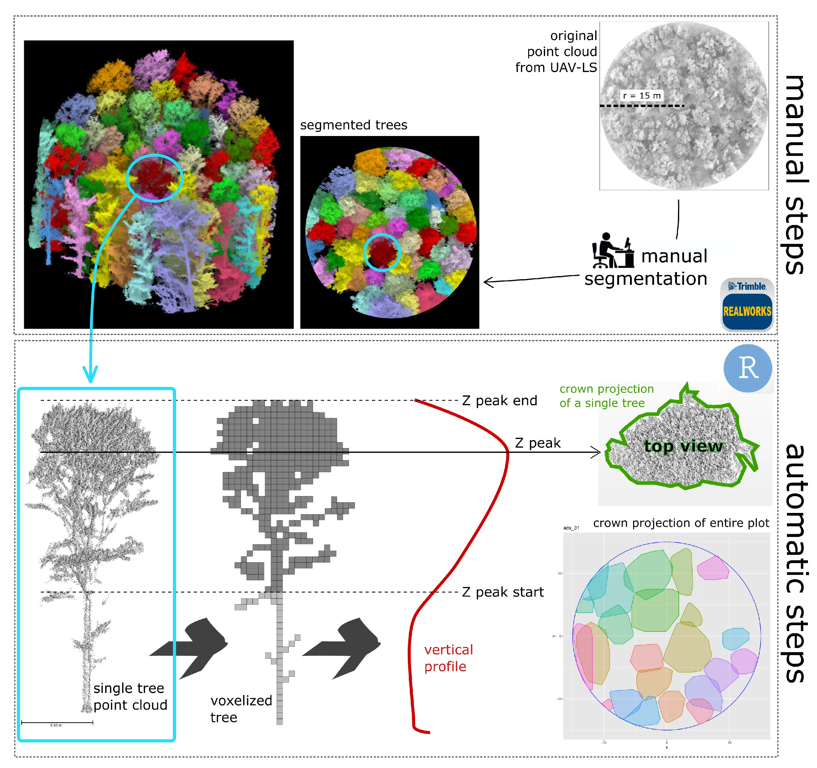
A Semi-Automatic Approach for Tree Crown Competition Indices Assessment from UAV LiDAR
beech forests
individual tree segmentation
precision forestry
size differation index
vertical profile traits
Mostra abstract
Understanding the spatial heterogeneity of forest structure is crucial for comprehending ecosystem dynamics and promoting sustainable forest management. Unmanned aerial vehicle (UAV) LiDAR technology provides a promising method to capture detailed three-dimensional (3D) information about forest canopies, aiding in management and silvicultural practices. This study investigates the heterogeneity of forest structure in broadleaf forests using UAV LiDAR data, with a particular focus on tree crown features and their different information content compared to diameters. We explored a non-conventionally used method that emphasizes crown competition by employing a nearest neighbor selection technique based on metrics derived from UAV point cloud profiles at the tree level, rather than traditional DBH (diameter at breast height) spatial arrangement. About 300 vegetation elements within 10 plots collected in a managed Beech forest were used as reference data. We demonstrate that crown-based approaches, which are feasible with UAV LiDAR data at a reasonable cost and time, significantly enhances the understanding of forest heterogeneity, adding new information content for managers. Our findings underscore the utility of UAV LiDAR in characterizing the complexity and variability of forest structure at high resolution, offering valuable insights for carbon accounting and sustainable forest management. © 2024 by the authors.

Improving Aboveground Biomass Estimation in Beech Forests with 3D Tree Crown Parameters Derived from UAV-LS
Mostra abstract
Accurate estimates of aboveground biomass (AGB) are essential for forest policies to reduce carbon emissions. Unmanned aerial laser scanning (UAV-LS) offers unprecedented millimetric detail but is underutilized in monitoring broadleaf Mediterranean forests compared to coniferous ones. This study aims to design and evaluate a procedure for AGB estimates based on the predictive power of crown features. In the first step, we manually created Quantitative Structure Models (QSMs) for 320 trees using data from UAV laser scanning (UAV-LS), airborne laser scanning (ALS), and co-registered terrestrial laser scanning (TLS). This provided the most accurate non-destructive estimate of aboveground biomass (AGB) in the absence of destructive measurements. For each reference tree we also measured crown projection and crown volume to build two separated models relating AGB to such crown features. In the second phase, we evaluated the potential of UAV-LS for quantifying AGB in a pure European beech (Fagus sylvatica) forest and compared it with traditional ALS estimates, using fully automatic procedures. The two obtained tree-level AGB models were then tested using three datasets derived from 35 sampling plots over the same study area: (a) 1130 trees manually segmented (phase-2 reference); (b) trees automatically extracted from ALS data; and (c) trees automatically extracted from UAV-LS data. Results demonstrate that detailed UAV-LS data improve model sensitivity compared to ALS data (RMSE = 45.6 Mg ha<sup>−1</sup>, RMSE% = 13.4%, R2 = 0.65, for the best ALS model; RMSE = 44.0 Mg ha<sup>−1</sup>, RMSE% = 12.9%, R2 = 0.67, for the best UAV-LS model), allowing for the detection of AGB differences even in quite homogenous forest structures. Overall, this study demonstrates the combined use of both laser scanner data can foster non-destructive and more precise AGB estimation than the use of only one, in forested areas across hectare scales (1 to 100 ha). © 2025 by the authors.
Benchmarking tree species classification from proximally sensed laser scanning data: Introducing the FOR-species20K dataset
Puliti
,
Stefano
,
Lines
,
Emily R.
,
Müllerová
,
Jana
,
Frey
,
Julian
,
Schindler
,
Zoe
,
Straker
,
Adrian
,
Allen
,
Matthew J.
,
Winiwarter
,
Lukas
,
Rehush
,
Nataliia
,
Hristova
,
Hristina S.
,
Murray
,
Brent A.
,
Calders
,
Kim
,
Coops
,
Nicholas C.
,
Höfle
,
Bernhard
,
Irwin
,
Liam A.K.
,
Junttila
,
Samuli
,
Kruček
,
Martin
,
Krok
,
G.
,
Král
,
Kamil
,
Levick
,
Shaun R.
,
Lück
,
Linda
,
Missarov
,
Azim
,
Mokroš
,
M.
,
Owen
,
Harry Jon Foord
,
Stereńczak
,
Krzysztof Jan
,
Pitkänen
,
Timo P.
,
Puletti
,
Nicola
,
Saarinen
,
Ninni
,
Hopkinson
,
Chris Dennis
,
Terryn
,
Louise
,
Torresan
,
C.
,
Tomelleri
,
Enrico
,
Weiser
,
Hannah
,
Astrup
,
Rasmus
Mostra abstract
Proximally sensed laser scanning presents new opportunities for automated forest ecosystem data capture. However, a gap remains in deriving ecologically pertinent information, such as tree species, without additional ground data. Artificial intelligence approaches, particularly deep learning (DL), have shown promise towards automation. Progress has been limited by the lack of large, diverse, and, most importantly, openly available labelled single-tree point cloud datasets. This has hindered both (1) the robustness of the DL models across varying data types (platforms and sensors) and (2) the ability to effectively track progress, thereby slowing the convergence towards best practice for species classification. To address the above limitations, we compiled the FOR-species20K benchmark dataset, consisting of individual tree point clouds captured using proximally sensed laser scanning data from terrestrial (TLS), mobile (MLS) and drone laser scanning (ULS). Compiled collaboratively, the dataset includes data collected in forests mainly across Europe, covering Mediterranean, temperate and boreal biogeographic regions. It includes scattered tree data from other continents, totaling over 20,000 trees of 33 species and covering a wide range of tree sizes and forms. Alongside the release of FOR-species20K, we benchmarked seven leading DL models for individual tree species classification, including both point cloud (PointNet++, MinkNet, MLP-Mixer, DGCNNs) and multi-view 2D-based methods (SimpleView, DetailView, YOLOv5). 2D Image-based models had, on average, higher overall accuracy (0.77) than 3D point cloud-based models (0.72). Notably, the performance was consistently >0.8 across scanning platforms and sensors, offering versatility in deployment. The top-scoring model, DetailView, demonstrated robustness to training data imbalances and effectively generalized across tree sizes. The FOR-species20K dataset represents an important asset for developing and benchmarking DL models for individual tree species classification using proximally sensed laser scanning data. As such, it serves as a crucial foundation for future efforts to classify accurately and map tree species at various scales using laser scanning technology, as it provides the complete code base, dataset, and an initial baseline representative of the current state-of-the-art of point cloud tree species classification methods. © 2025 The Author(s). Methods in Ecology and Evolution published by John Wiley & Sons Ltd on behalf of British Ecological Society.
LAIr: an R package to estimate LAI from Normalized Difference Vegetation Index
Bajocco
,
Sofia
,
Ferrara
,
Carlotta
,
Savian
,
Francesco
,
Ginaldi
,
Fabrizio
,
Puletti
,
Nicola
,
Crecco
,
Lorenzo
,
Bregaglio
,
Simone Ugo Maria
,
Chianucci
,
Francesco
Mostra abstract
Leaf area index (LAI) is an important biophysical parameter describing vegetation. LAI is typically retrieved from optical remote sensing by empirical models relating LAI to vegetation indices, such as the Normalized Difference Vegetation Index (NDVI). As the relationship between LAI and NDVI is non-linear and crop type dependant, several specific empirical equations relating LAI to NDVI have been developed using field data. This study presented LAIr, an R package to derive LAI from NDVI data from the most comprehensive library of conversion equations. In the package, the range of functions differs on environmental factors, sensors, and vegetation types, allowing flexibility in choosing appropriate options based on specific application, scale of investigation and data availability. We illustrated the use of the package with a case study to compare a generic LAI product with specific NDVI-based LAI estimations. By leveraging empirical knowledge, LAIr enables accurate and context-specific estimation of LAI. The deployment of an open-source R package serves as a valuable tool for aiding researchers in selecting the most appropriate equations for conducting NDVI-to-LAI conversion. © 2024
Comparative analysis of taper models for Pinus nigra Arn. using terrestrial laser scanner acquired data
Boukhris
,
Issam
,
Puletti
,
Nicola
,
Vonderach
,
Christian
,
Guasti
,
Matteo
,
Lahssini
,
Said
,
Santini
,
Monia
,
Valentini
,
Riccardo
forest mensuration
b-splines
environmental management
forest as-sessment
max and burkhart
random forest
taper equations
tls
volume equations
Mostra abstract
Taper equations are indispensable tools for characterizing the stem profile of trees, providing valuable insights for forest management, timber inventory, and optimal assortments allocation. The recent progress in Terrestrial Laser Scanning (TLS) has revolutionized forest inventory practices by enabling non-destructive data collection. In this study, four taper models from three different model categories were established based on point cloud data of 219 Pinus nigra trees. The taper equations fitted with TLS data were used to predict the diameter at specific stem heights and the total stem volume. The results show that among fitted models, the Max and Burkhart segmented model calibrated by the means of a mixed-effects approach provided the best estimate of the diameter at different heights and the total stem volume evaluated for different diameter at breast height (DBH) classes. In numerical terms, this model es-timated the diameter and the volume with a respective overall error of 0.781 cm and 0.021 m<sup>3</sup>. The predicted profile also shows that above a relative height of 0.7, the diameter error tends to increase due to the low reliability of data collected beyond the base of the crown primarily caused by interference from branches and leaves. Nevertheless, this study shows that TLS technology presents a compelling opportunity and a promising non-destructive alternative for generating taper profiles and estimating tree volume. © SISEF.
Estimating canopy and stand structure in hybrid poplar plantations from multispectral UAV imagery
Romano
,
Elio
,
Brambilla
,
Massimo
,
Chianucci
,
Francesco
,
Tattoni
,
Clara
,
Puletti
,
Nicola
,
Chirici
,
Gherardo
,
Travaglini
,
Davide
,
Giannetti
,
Francesca
canopy photography
canopy structure
poplar plantation
texture metrics
digital camera
gclm metrics
unmanned aerial vehicle
Mostra abstract
Accurate estimates of canopy structure like canopy cover (CC), Leaf Area Index (LAI), crown volume (Vcr), as well as tree and stand structure like stem volume (V_st) and basal area (G), are considered essential measures to manage poplar plantations effectively as they are correlated with the growth rate and the detection of possible stress. This research exploits the possibility of developing a precision forestry application using an unmanned aerial vehicle (UAV), terrestrial digital camera and traditional field measurements to monitor poplar plantation variables. We set up the procedure using explanatory variables from the Grey Level Co-occurrence Matrix textural metrics (Entropy, Variance, Dissimilarity and Contrast) calculated based on UAV multispectral imagery. Our results show that the GCLM texture derived by multispectral ortomosaic provides adequate explanatory variables to predict poplar plantation characteristics related to plants' canopy and stand structure. The evaluation of the models targeting the different poplar plantation variables (i.e. Vcr, G_ha, Vst_ha, CC and LAI) with the four GLCM explanatory variables (i.e. Entropy, Variance, Dissimilarity and Contrast) consistently higher or equal resulted to R<sup>2</sup> ≥0.86. © 2024, Editura Silvica. All rights reserved.
Moths in space: The below-canopy structure of forest drives abundance and mobility-related traits of moth communities
La Cava
,
Sara
,
Rijllo
,
Giuseppe
,
Zucco
,
Giada
,
Innocenti
,
Simone
,
Guasti
,
Matteo
,
Puletti
,
Nicola
,
Ferrara
,
Carlotta
,
Scalercio
,
S.
Mostra abstract
The distribution of species is primarily driven by the availability of trophic resources. In a given forest type, insects trophically related to the dominant tree are expected to be evenly distributed due to the abundance of their foodplant. However, their distribution is also influenced by complex relationships with abiotic and biotic parameters such as available space, predatory pressure, and morphometric traits. In this study, we investigated how the three-dimensional structure of space below the canopy may affect the composition of nocturnal lepidoptera communities. To synthesise the complexity of the dispersal behaviour of these insects, we evaluated easily measurable traits such as wingspan and the presence of tympanic organs, both connected to their mobility and thus potentially influenced by the structure of the available flight space. The study was conducted in the Sila National Park (Italy), where 12 sampling sites were selected in pine forests and an additional 12 in beech forests. Forest spatial structure was investigated using a portable terrestrial laser scanner. Moths were sampled monthly using light traps from May to October in both 2019 and 2020. Among measured forest traits, we observed that the space above three meters from the ground is the only factor influencing community composition. Larger species with tympanic organs prefer environments with less space below tree canopies. Our findings could be the starting point for future studies that investigate a potential defence strategy of moths against bats, as tympanate and larger species not only actively avoid chiropter predation but could also choose denser forests because of a lower bat activity. Moths' distribution and community composition thus appear to be significantly shaped by the spatial structure of forests. © 2024 Elsevier B.V.
Multiple drivers of functional diversity in temperate forest understories: Climate, soil, and forest structure effects
Chelli
,
Stefano
,
Bricca
,
Alessandro
,
Tsakalos
,
James L.
,
Andreetta
,
Anna
,
Bonari
,
Gianmaria
,
Campetella
,
Giandiego
,
Carnicelli
,
Stefano
,
Cervellini
,
Marco
,
Puletti
,
Nicola
,
Wellstein
,
Camilla
,
Canullo
,
R.
climate change
functional diversity
bud bank
forest management
plant height
seed mass
specific leaf area
Mostra abstract
In macroecology, shifting from coarse- to local-scale explanatory factors is crucial for understanding how global change impacts functional diversity (FD). Plants possess diverse traits allowing them to differentially respond across a spectrum of environmental conditions. We aim to assess how macro- to microclimate, stand-scale measured soil properties, forest structure, and management type, influence forest understorey FD at the macroecological scale. Our study covers Italian forests, using thirteen predictors categorized into climate, soil, forest structure, and management. We analyzed five traits (i.e., specific leaf area, plant size, seed mass, belowground bud bank size, and clonal lateral spread) capturing independent functional dimensions to calculate the standardized effect size of functional diversity (SES-FD) for all traits (multi-trait) and for single traits. Multiple regression models were applied to assess the effect of predictors on SES-FD. We revealed that climate, soil, and forest structure significantly drive SES-FD of specific leaf area, plant size, seed mass, and bud bank. Forest management had a limited effect. However, differences emerged between herbaceous and woody growth forms of the understorey layer, with herbaceous species mainly responding to climate and soil features, while woody species were mainly affected by forest structure. Future warmer and more seasonal climate could reduce the diversity of resource economics, plant size, and persistence strategies of the forest understorey. Soil eutrophication and acidification may impact the diversity of regeneration strategies; canopy closure affects the diversity of above- and belowground traits, with a larger effect on woody species. Multifunctional approaches are vital to disentangle the effect of global changes on functional diversity since independent functional specialization axes are modulated by different drivers. © 2024 The Authors
A co-registration approach between terrestrial and UAV laser scanning point clouds based on ground and trees features
Mostra abstract
Accurate co-registration of terrestrial and aerial point clouds can provide a high-resolution description of tree components across large forest areas. However, a semi-automatic approach for co-registering point clouds is still needed, given the challenges in geospatial data processing, particularly in complex topographical conditions. The main objective of this study is to present the application of a novel procedure for the co-registration of point clouds obtained from terrestrial and UAV surveys in Mediterranean forests. The proposed methodology proves to be promising and will constitute the basis for experimentation on a larger scale. © 2024 Istituto Sperimentale per la Selvicoltura. All rights reserved.
Performance assessment of two plotless sampling methods for density estimation applied to some Alpine forests of northeastern Italy
accuracy
conditional inference trees
distance-based density estimator
forest monitoring
ordered distance method
point-centred quarter method
precision
Mostra abstract
In this study, we tested two plotless sampling methods, the ordered distance method and point-centred quarter method, to estimate the tree density and basal area in some managed Alpine forests in northeastern Italy. We selected nine independent forest stands, classified according to the spatial distribution patterns of trees (cluster, random, regular). A plotless sampling survey was simulated within the selected stands and the tree density and basal area were estimated by applying both the ordered distance method and point-centred quarter method. We compared the estimates, in terms of accuracy and preci-sion, between the two methods and against estimates obtained from a simulated survey based on a plot-based sampling method. The point-centred quarter method outperformed the ordered distance method in terms of both accuracy and precision, showing higher robustness towards the bias related to non-random spatial patterns. However, both the plotless methods we tested can provide unbiased accuracy of estimates which, in addition, do not differ from estimates of plot-based sampling. The satisfactory results are encouraging for further tests over other Italian Alpine as well as Apennine forests. If con-firmed, the plotless sampling method, especially the point-centred quarter method, could represent an effective alternative whenever plot-based sampling is deemed redundant, or expensive. © SISEF.
Mapping Understory Vegetation Density in Mediterranean Forests: Insights from Airborne and Terrestrial Laser Scanning Integration
forest biodiversity
lidar
terrestrial laser scanner
forest structure
spatial prediction
voxelization
Mostra abstract
The understory is an essential ecological and structural component of forest ecosystems. The lack of efficient, accurate, and objective methods for evaluating and quantifying the spatial spread of understory characteristics over large areas is a challenge for forest planning and management, with specific regard to biodiversity and habitat governance. In this study, we used terrestrial and airborne laser scanning (TLS and ALS) data to characterize understory in a European beech and black pine forest in Italy. First, we linked understory structural features derived from traditional field measurements with TLS metrics, then, we related such metrics to the ones derived from ALS. Results indicate that (i) the upper understory density (5–10 m above ground) is significantly associated with two ALS metrics, specifically the mean height of points belonging to the lower third of the ALS point cloud within the voxel (HM<inf>1/3</inf>) and the corresponding standard deviation (SD<inf>1/3</inf>), while (ii) for the lower understory layer (2–5 m above ground), the most related metric is HM<inf>1/3</inf> alone. As an example application, we have produced a map of forest understory for each layer, extending over the entire study region covered by ALS data, based on the developed spatial prediction models. With this study, we also demonstrated the power of hand-held mobile-TLS as a fast and high-resolution tool for measuring forest structural attributes and obtaining relevant ecological data. © 2023 by the authors.
Wall-to-Wall Mapping of Forest Biomass and Wood Volume Increment in Italy
Giannetti
,
Francesca
,
Chirici
,
Gherardo
,
Vangi
,
Elia
,
Corona
,
P.
,
Maselli
,
Fabio
,
Chiesi
,
Marta
,
D'Amico
,
Giovanni
,
Puletti
,
Nicola
Mostra abstract
Several political initiatives aim to achieve net-zero emissions by the middle of the twenty-first century. In this context, forests are crucial as a carbon sink to store unavoidable emissions. Assessing the carbon sequestration potential of forest ecosystems is pivotal to the availability of accurate forest variable estimates for supporting international reporting and appropriate forest management strategies. Spatially explicit estimates are even more important for Mediterranean countries such as Italy, where the capacity of forests to act as sinks is decreasing due to climate change. This study aimed to develop a spatial approach to obtain high-resolution maps of Italian forest above-ground biomass (ITA-BIO) and current annual volume increment (ITA-CAI), based on remotely sensed and meteorological data. The ITA-BIO estimates were compared with those obtained with two available biomass maps developed in the framework of two international projects (i.e., the Joint Research Center and the European Space Agency biomass maps, namely, JRC-BIO and ESA-BIO). The estimates from ITA-BIO, JRC-BIO, ESA-BIO, and ITA-CAI were compared with the 2nd Italian NFI (INFC) official estimates at regional level (NUT2). The estimates from ITA-BIO are in good agreement with the INFC estimates (R<sup>2</sup> = 0.95, mean difference = 3.8 t ha<sup>−1</sup>), while for JRC-BIO and ESA-BIO, the estimates show R<sup>2</sup> of 0.90 and 0.70, respectively, and mean differences of 13.5 and of 21.8 t ha<sup>−1</sup> with respect to the INFC estimates. ITA-CAI estimates are also in good agreement with the INFC estimates (R<sup>2</sup> = 0.93), even if they tend to be slightly biased. The produced maps are hosted on a web-based forest resources management Decision Support System developed under the project AGRIDIGIT (ForestView) and represent a key element in supporting the new Green Deal in Italy, the European Forest Strategy 2030 and the Italian Forest Strategy. © 2022 by the authors.
coveR: an R package for processing digital cover photography images to retrieve forest canopy attributes
Mostra abstract
Key message: coveR is an R package for estimating canopy attributes from digital cover photography (DCP) images. The simplicity of the method and the open-accessibility of coveR can effectively extend the accessibility and applicability of DCP to a wider audience. Abstract: Digital cover photography (DCP) is an increasingly popular tool for estimating canopy cover and leaf area index (LAI). However, existing solutions to process canopy images are predominantly tailored for hemispherical photography, whereas open-access tools for DCP are lacking. We developed an R package (coveR) to support the whole processing of DCP images in an automated, fast, and reproducible way. The package functions, which are designed for step-by-step single-image analysis, can be performed sequentially in a pipeline while ensuring quality-checking of each processing step. A wrapper function ‘coveR()’ is also created to perform all the image processing workflow in a single function. A case study is presented to demonstrate the reliability of canopy attributes derived from coveR in pure beech (Fagus sylvatica L.) stands with variable canopy density and structure. Estimates of gap fraction and effective LAI from DCP were validated against reference measurements obtained from terrestrial laser scanning. By providing a simple, transparent, and flexible image processing procedure, coveR supported the use of DCP for routine measurements and monitoring of forest canopy attributes. This, combined with the possibility to implement DCP in many devices, including smartphones, micro-cameras, and remote trail cameras, can greatly expand the accessibility of the method also by non-experts. © 2022, The Author(s), under exclusive licence to Springer-Verlag GmbH Germany, part of Springer Nature.
From model selection to maps: A completely design-based data-driven inference for mapping forest resources
Di Biase
,
Rosa Maria
,
Fattorini
,
Lorenzo
,
Franceschi
,
Sara
,
Grotti
,
Mirko
,
Puletti
,
Nicola
,
Corona
,
P.
density estimation
harmonization
model selection
predictions
pseudopopulation bootstrap
regression estimator
residuals
smoothing parameter
spatial interpolation
Mostra abstract
A completely data-driven, design-based sampling strategy is proposed for mapping a forest attribute within the spatial units tessellating a survey region. Based on sample data, a model is selected, and model parameters are estimated using least-squares criteria for predicting the attribute of interest within units as a linear function of a set of auxiliary variables. The spatial interpolation of residuals arising from model predictions is performed by inverse distance weighting. The leave-one-out cross validation procedure is adopted for selecting the smoothing parameter used for interpolation. The densities of the attributes of interest within units are estimated by summing predictions and interpolated residuals. Finally, density estimates are rescaled to match the total estimate over the survey region obtained by the traditional regression estimator with the total estimate obtained from the map as the sum of the density estimates within units. A bootstrap procedure accounts for the uncertainty. The consistency of the strategy is proven by incorporating previous results. A simulation study is performed and an application for mapping wood volume densities in the forest estate of Rincine (Central Italy) is described. © 2022 John Wiley & Sons Ltd.
Potential of ALOS2 Polarimetric Imagery to Support Management of Poplar Plantations in Northern Italy
Vaglio Laurin
,
Gaia
,
Mattioli
,
Walter
,
Innocenti
,
Simone
,
Lombardo
,
Emanuela
,
Valentini
,
Riccardo
,
Puletti
,
Nicola
Mostra abstract
Poplar is one of the most widespread fast-growing forest species. In Northern Italy, plantations are characterized by large interannual fluctuations, requiring frequent monitoring to inform on wood supply and to manage the stands. The use of radar satellite data is proving useful for forest monitoring, being weather independent and sensitive to the changes in forest canopy structure, but it has been scarcely tested in the case of poplar. Here, L-band ALOS2 (Advanced Land Observing Satellite-2) dual-pol data were tested to detect clear-cut plantations in consecutive years. ALOS2 quad-pol data were used to discriminate among different age classes, a much complex task than detecting poplar plantations extent. Results from different machine learning algorithms indicate that with dual-pol data, poplar forest can be discriminated from clear-cut areas with 80% overall accuracy, similar to what is usually obtained with optical data. With quad-pol data, four age classes were classified with moderate overall accuracy (73%) based on polarimetric decompositions, three 3 age classes with higher accuracy (87%) based on HV band. Sources of error are represented by poplar areas of intermediate age when stems, branches and leaves were not developed enough to detect by scattering mechanisms. This study demonstrates the feasibility of monitoring poplar plantations with satellite radar, which represents a growing source of information thanks to already-planned future satellite missions. © 2022 by the authors.
A georeferenced dataset of nocturnal macrolepidoptera: A tool for forest management and biodiversity conservation
Mostra abstract
In this paper we provide a georeferenced dataset of raw data concerning occurrence and abundance of nocturnal macrolepidoptera, an insect group largely recognized as a good ecological indicator of forest ecosystems. Data have been collected by using light traps located in 15 beech and 20 Calabrian black pine forest lots, 20 of which included in Natura 2000 sites. The sampling was carried out monthly lasting from May to late October 2019 and 2020 in order to cover the entire period during which favourable conditions for adult monitoring occurred, and to encompass phenological changes occurring across seasons in moth diversity. The dataset is composed by a total of 42,834 individuals belonging to 363 species. Due to the relatively small attractive radius of used light traps (about 25 m), georeferenced lepidopteran data can be easily correlated to any kind of spatial environmental variables and forest attributes and to their temporal variations being useful to quantify also the effects of long-term ecological drivers. © 2022
Enhancing wall-to-wall forest structure mapping through detailed co-registration of airborne and terrestrial laser scanning data in Mediterranean forests
Mostra abstract
This paper presents a new co-registration procedure of complementary point clouds captured by both Terrestrial (TLS) and Airborne Laser Scanning (ALS) technologies. Starting from the geographic position of the TLS point cloud, a geometric features recognition algorithm, which evaluates digital terrain models obtained from both ALS and TLS, was developed and implemented in a new GIS software (ForeSight®). As a case study, we tested this new approach using point clouds acquired from both hand-held mobile TLS and ALS sensors over 24 test sites located in a protected area in southern Italy, with the ultimate goal of characterizing the different forest stand structures. From each aligned point cloud, a plot-level spatially explicit index (Enhanced Structural Spatial Index, ESCI) was derived to assess the three-dimensional structure of the considered forest stands. Then, we compared structural features derived from the ESCI index with different computed ALS metrics. Finally, the most correlated ALS metrics were used as predictors to produce an ESCI-map of the entire region of interest. © 2021 Elsevier B.V.
Estimated biomass loss caused by the vaia windthrow in northern italy: Evaluation of active and passive remote sensing options
Vaglio Laurin
,
Gaia
,
Puletti
,
Nicola
,
Tattoni
,
Clara
,
Ferrara
,
Carlotta
,
Pirotti
,
Francesco
Mostra abstract
Windstorms are a major disturbance factor for European forests. The 2018 Vaia storm, felled large volumes of timber in Italy causing serious ecological and financial losses. Remote sensing is fundamental for primary assessment of damages and post‐emergency phase. An explicit estimation of the timber loss caused by Vaia using satellite remote sensing was not yet undertaken. In this investigation, three different estimates of timber loss were compared in two study sites in the Alpine area: pre‐existing local growing stock volume maps based on lidar data, a recent national‐level forest volume map, and an novel estimation of AGB values based on active and passive remote sensing. The compared datasets resemble the type of information that a forest manager might potentially find or produce. The results show a significant disagreement in the different biomass estimates, related to the methods used to produce them, the study areas characteristics, and the size of the damaged areas. These sources of uncertainty highlight the difficulty of estimating timber loss, unless a unified national or regional European strategy to improve preparedness to forest hazards is defined. Considering the frequent impacts on forest resources that occurred in the last years in the European Union, remote sensing‐based surveys targeting forests is urgent, particularly for the many European countries that still lack reliable forest stocks data. © 2021 by the authors. Licensee MDPI, Basel, Switzerland.
Characterizing subcanopy structure of Mediterranean forests by terrestrial laser scanning data
forest biodiversity
lidar
terrestrial laser scanner
forest structure
spatial prediction
voxelization
Mostra abstract
Vegetation structure is one of the key factors in forest ecosystems. Especially understory structure has major implications for wildlife habitat selection, reproduction, and survival. Structural indices traditionally used to characterize understory vegetation are based on field vegetation surveys describing general features such as leaf area index (LAI), canopy cover or vegetation height, hiding much of the three-dimensional vegetation structure complexity. The application of terrestrial laser scanning (TLS) in forest ecological and management applications is becoming more effective. In this study, we use TLS data to quantify spatial attributes of forest subcanopy in four different forest strata ranging from 0.5 m to 10 m from the ground. We collected data in 12 plots of mature European beech (Fagus sylvatica L.) forests and 12 plots of mature black pine (Pinus nigra subsp. laricio Maire) forests, located in the Sila National Park, Italy. We propose a TLS-based approach to estimate a fine-scale vegetation density using the Plant Density Index (PDI) and to test the PDI at different height classes. We found a significant relationship between the PDI and the number of trees belonging to the dominant layer, using the Spearman correlation coefficient (r = 0.83, p<inf>val</inf> = 0.001). Basing on PDI values, a cluster analysis of the four subcanopy strata was carried out for deriving clusters of structurally homogeneous forest plots. Results identified three clusters in terms of the vegetation features in the horizontal height classes: the first cluster primarily includes Beech forests characterized by plots with the highest tree densities; the second one includes both Beech and Pine forests characterized by dense ground vegetation and shrubs and an intermediate tree density; the third group is represented by Pine forests with massive presence of vegetation lower strata and moderate tree density. Then, PCA allowed identifying the relationship between the considered subcanopy layers and forest plots. © 2021 Elsevier B.V.
Traditional and TLS-based forest inventories of beech and pine forests located in Sila National Park: A dataset
Mostra abstract
Vegetation structure is a key determinant of species distribution and diversity. Compared to traditional methods, the use of Terrestrial Laser Scanning (TLS) has allowed massive amounts of point cloud data collected for quantifying three-dimensional habitat properties at increasing spatial and temporal scales. We used TLS to characterize the forest plots across a broad range of forest structural diversity, located in the Sila National Park, South Italy. The dataset reports data collected in 24 15-m-radius circular plots, 12 of which were dominated by beech (Fagus sylvatica L.) and 12, by black pine (Pinus nigra subsp. laricio). In detail, this work provides dataset of i) plot-level attributes calculated from raw data, such as the number of trees, ii) tree-level data, comprising a total of 1709 trees, with information related to field-based forest inventory such as the diameter at breast height (DBH), and iii) plot-level information related to the time for conducting both traditional field- and TLS-based forest inventories. Compared to traditional methods, the use of TLS allows a very high-resolution quantification of the 3D forest structural properties, also reducing the time for conducting forest inventories. © 2020
Influence of voxel size and point cloud density on crown cover estimation in poplar plantations using terrestrial laser scanning
Mostra abstract
Accurate estimates of crown cover (CC) are central for a wide range of forestry studies. As direct measurements do not exist to retrieve this variable in the field, CC is conventionally determined from optical measurements as the complement of gap fraction close to the zenith. As an alternative to passive optical measurements, active sensors like terrestrial Light Detection And Ranging (LiDAR) allows for characterizing the 3D canopy structure with unprecedented detail. We evaluated the reliability of terrestrial LiDAR (TLS) to estimate CC using a voxel-based approach. Specifically, we tested how different voxel sizes (ranging from 5-20 cm) and voxel densities (1-9 points/dm<sup>3</sup>) influenced the retrieval of CC. Results were compared against benchmark values obtained from digital cover photography (DCP). The trial was performed in hybrid poplar plantations in Northern Italy. Results indicate that TLS can be used for obtaining accurate estimates of CC, but the choice of voxel size and point density is critical for achieving such accuracy. In hybrid poplars, the best performance was obtained using voxel size of 10 cm and point density of 8 points/dm<sup>3</sup>. The combined ability of measuring and mapping CC also holds great potential to use TLS for calibrating and upscaling results using coarser-scale remotely sensed products. © 2021 Centro di Ricerca per la Selvicoltura, Consiglio per la Ricerca in Agricoltura e l'Analisi dell'Economia Agraria. All rights reserved.
A deep learning approach for automatic mapping of poplar plantations using Sentinel-2 imagery
D'Amico
,
Giovanni
,
Francini
,
Saverio
,
Giannetti
,
Francesca
,
Vangi
,
Elia
,
Travaglini
,
Davide
,
Chianucci
,
Francesco
,
Mattioli
,
Walter
,
Grotti
,
Mirko
,
Puletti
,
Nicola
,
Corona
,
P.
,
Chirici
,
Gherardo
deep learning
big data
forest tree crops
fully connected neural networks
multitemporal classification
tree species mapping
Mostra abstract
Poplars are one of the most widespread fast-growing tree species used for forest plantations. Owing to their distinct features (fast growth and short rotation) and the dependency on the timber price market, poplar plantations are characterized by large inter-annual fluctuations in their extent and distribution. Therefore, monitoring poplar plantations requires a frequent update of information–not feasible by National Forest Inventories due to their periodicity–achievable by remote sensing systems applications. In particular, the new Sentinel-2 mission, with a revisiting period of 5 days, represents a potentially efficient tool for meeting this need. In this paper, we present a deep learning approach for mapping poplar plantations using Sentinel-2 time series. A reference dataset of poplar plantations was available for a large study area of more than 46,000 km<sup>2</sup> in Northern Italy and served as training and testing data. Two classification methods were compared: (1) a fully connected neural network (also called multilayer perceptron), and (2) a traditional logistic regression. The performance of the two approaches was estimated through bootstrapping procedure with a confidence interval of 99%. Results indicated for deep learning an omission error rate of 2.77%±2.76%, showing improvements compared to logistic regression, omission error rate = 8.91%±4.79%. © 2021 Informa UK Limited, trading as Taylor & Francis Group.
Estimation of forest leaf area index using satellite multispectral and synthetic aperture radar data in Iran
Vafaei
,
Sasan
,
Fathizadeh
,
Omid
,
Puletti
,
Nicola
,
Fadaei
,
Hadi
,
Rasooli
,
Sabri Baqer
,
Vaglio Laurin
,
Gaia
Mostra abstract
Different satellite datasets, including multispectral Sentinel 2 and synthetic aperture radar Sentinel 1 and ALOS2, were tested to estimate the Leaf Area Index (LAI) in the Zagros forests, Ilam province, in Iran. Field data were collected in 61 sample plots by hemispherical photographs, to train and validate the LAI estimation models. Different satellite data combinations were used as input in regression models built with the following algorithms: Multiple Linear Regression, Random Forests, and Partial Least Square Regression. The results indicate that Leaf Area Index can be best estimated using integrated ALOS2 and Sentinel 2 data; these inputs generated the model with higher accuracy (R<sup>2</sup> = 0.84). The combination of a single band and a vegetation index from Sentinel 2 also led to successful results (R<sup>2</sup> = 0.81). Lower accuracy was obtained when using only ALOS 2 (R<sup>2</sup> = 0.72), but this dataset is helpful where cloud coverage affects optical data. Sentinel 1 data was not useful for LAI predic-tion. The optimal model was based on the traditional Multiple Linear Regression algorithm, using a preliminary input selection step to exclude multi-collinearity effects. To avoid this step, the use of Partial Least Square Regression may be an alternative, as this algorithm was able to produce estimates similar to those obtained with the best model. © SISEF.
Influence of image pixel resolution on canopy cover estimation in poplar plantations from field, aerial and satellite optical imagery
Chianucci
,
Francesco
,
Puletti
,
Nicola
,
Grotti
,
Mirko
,
Bisaglia
,
Carlo
,
Giannetti
,
Francesca
,
Romano
,
Elio
,
Brambilla
,
Massimo
,
Mattioli
,
Walter
,
Cabassi
,
Giovanni
,
Bajocco
,
Sofia
,
Li
,
Linyuan
,
Chirici
,
Gherardo
,
Corona
,
P.
,
Tattoni
,
Clara
Mostra abstract
Accurate estimates of canopy cover (CC) are central for a wide range of forestry studies. As direct measurements are impractical, indirect optical methods have often been used to estimate CC from the complement of gap fraction measurements obtained with restricted-view sensors. In this short note we evaluated the influence of the image pixel resolution (ground sampling distance; GSD) on CC estimation in poplar plantations obtained from field (cover photography; GSD < 1 cm), unmanned aerial (UAV; GSD <10 cm) and satellite (Sentinel-2; GSD = 10 m) imagery. The trial was conducted in poplar tree plantations in Northern Italy, with varying age and canopy cover. Results indicated that the coarser resolution available from satellite data is suitable to obtain estimates of canopy cover, as compared with field measurements obtained from cover photography; therefore, S2 is recommended for larger scale monitoring and routine assessment of canopy cover in poplar plantations. The higher resolution of UAV compared with Sentinel-2 allows finer assessment of canopy structure, which could also be used for calibrating metrics obtained from coarser-scale remote sensing products, avoiding the need of ground measurements. © 2021 Centro di Ricerca per la Selvicoltura, Consiglio per la Ricerca in Agricoltura e l'Analisi dell'Economia Agraria. All rights reserved.
Nondestructive tree stem and crown volume allometry in hybrid poplar plantations derived from terrestrial laser scanning
Chianucci
,
Francesco
,
Puletti
,
Nicola
,
Grotti
,
Mirko
,
Ferrara
,
Carlotta
,
Giorcelli
,
Achille
,
Coaloa
,
Domenico
,
Tattoni
,
Clara
Mostra abstract
Accurate and frequently updated tree volume estimates are required for poplar plantations, which are characterized by fast growth rate and short rotation. In this study, we tested the potential of terrestrial laser scanning (TLS) as a reliable method for developing nondestructive tree volume allometries in poplar plantations. The trial was conducted in Italy, where 4- to 10-year-old hybrid plantations were sampled to develop tree crown volume allometry in leaf-on conditions, tree stem volume, and height-diameter allometries in leaf-off conditions. We tested one-entry models based on diameter and two-entry models based on both diameter and height. Model performance was assessed by residual analysis. Results indicate that TLS can provide accurate models of tree stem and crown volume, with percentage of root-mean-square error of about 20 percent and 15 percent, respectively. The inclusion of height does not bring relevant improvement in the models, so that only diameter can be used to predict tree stem and crown volume. The TLS-measured stem volume estimates agreed with an available formula derived from harvesting. We concluded that TLS is a reliable method for developing nondestructive volume allometries in poplar plantations and holds great potential to enhance conventional tree inventory and monitoring. © The Author(s) 2020. Published by Oxford University Press on behalf of the Society of American Foresters. All rights reserved.
Plant functional traits are correlated with species persistence in the herb layer of old-growth beech forests
Campetella
,
Giandiego
,
Chelli
,
Stefano
,
Simonetti
,
Enrico
,
Damiani
,
Claudia
,
Bartha
,
Sándor
,
Wellstein
,
Camilla
,
Giorgini
,
Daniele
,
Puletti
,
Nicola
,
Mucina
,
Ladislav
,
Cervellini
,
Marco
,
Canullo
,
R.
beech
forest
genetics
plant leaf
plant seed
quantitative trait
fagus
forests
plant leaves
heritable
seeds
Mostra abstract
This paper explores which traits are correlated with fine-scale (0.25 m<sup>2</sup>) species persistence patterns in the herb layer of old-growth forests. Four old-growth beech forests representing different climatic contexts (presence or absence of summer drought period) were selected along a north–south gradient in Italy. Eight surveys were conducted in each of the sites during the period spanning 1999–2011. We found that fine-scale species persistence was correlated with different sets of plant functional traits, depending on local ecological context. Seed mass was found to be as important for the fine-scale species persistence in the northern sites, while clonal and bud-bank traits were markedly correlated with the southern sites characterised by summer drought. Leaf traits appeared to correlate with species persistence in the drier and wetter sites. However, we found that different attributes, i.e. helomorphic vs scleromorphic leaves, were correlated to species persistence in the northernmost and southernmost sites, respectively. These differences appear to be dependent on local trait adaptation rather than plant phylogenetic history. Our findings suggest that the persistent species in the old-growth forests might adopt an acquisitive resource-use strategy (i.e. helomorphic leaves with high SLA) with higher seed mass in sites without summer drought, while under water-stressed conditions persistent species have a conservative resource-use strategy (i.e. scleromorphic leaves with low SLA) with an increased importance of clonal and resprouting ability. © 2020, The Author(s).
Probabilistic sampling and estimation for large-scale assessment of poplar plantations in Northern Italy
Corona
,
P.
,
Chianucci
,
Francesco
,
Marcelli
,
Agnese
,
Gianelle
,
Damiano
,
Fattorini
,
Lorenzo
,
Grotti
,
Mirko
,
Puletti
,
Nicola
,
Mattioli
,
Walter
Mostra abstract
In the recent decades, growing demand for wood products, combined with efforts to conserve natural forests, has supported a steady increase in the global extent of planted forests. In this paper, a two-phase sampling strategy for large-scale assessment of hybrid poplar plantations in Northern Italy was implemented. The first phase was performed by means of tessellation stratified sampling on high-resolution remotely sensed imagery, covering the survey area by a grid of regular polygons of equal size and randomly and independently selecting one point per quadrat. All the plantations spotted by at least one sample point were selected. In the second phase, we randomly chosen a subset of plantations by stratified sampling that were visited on the ground to collect qualitative and quantitative attributes. The resulting estimates were reliable, and the survey demonstrated relatively easy to be implemented and replicated. These considerations support the use of the proposed sampling strategy to frequently update information on fast-growing forest plantations within agricultural farms, like hybrid poplar crops. Moreover, the results of the case study here presented highlight the relevance of hybrid poplar plantations in Italy, in the context of sustainable development strategies under a green economy perspective. © 2020, Springer-Verlag GmbH Germany, part of Springer Nature.
Species dominance and above ground biomass in the Białowieża Forest, Poland, described by airborne hyperspectral and lidar data
Vaglio Laurin
,
Gaia
,
Puletti
,
Nicola
,
Grotti
,
Mirko
,
Stereńczak
,
Krzysztof Jan
,
Modzelewska
,
Aneta
,
Lisiewicz
,
Maciej
,
Sadkowski
,
Rafał
,
Kuberski
,
Łukasz
,
Chirici
,
Gherardo
,
Papale
,
Dario
climate change
lidar
aboveground biomass
algorithm
data set
deciduous tree
species diversity
species richness
vegetation dynamics
bialowieza forest
scolytinae
Mostra abstract
The objective of this research is to test and evaluate hyperspectral and lidar data to derive information on tree species dominance and above ground biomass in the Białowieża Forest in Poland. This forest is threatened by climate change, fire, bark beetles attacks, and logging, with changes in species composition and dominance. In this conservation valuable area, the monitoring of forest resources is thus critical. Results indicate that vegetation indices from hyperspectral data can support species dominance detection: using a Classification and Regression Trees algorithm the three main plot types (dominated by Deciduous, Spruce, and Pines species) were classified with an Overall Accuracy > 0.9. The accuracy decreased when a ‘Mixed’ group was added to account for very heterogeneous plots, and plots dominated by Spruce were not correctly detected. Hyperspectral vegetation indices were also used to estimate the level of species dominance in the forest plots, using a Multivariate Multiple Linear Regression model; the obtained accuracy varied according to groups, being higher for Deciduous (R<sup>2</sup> = 0.87), compared to Pines (R<sup>2</sup> = 0.61), and to Spruce-dominated plots (R<sup>2</sup> = 0.37). Lidar data were employed to estimate above ground biomass, using an exponential regression model; overall the R<sup>2</sup> resulted equal to 0.66 but ranged from 0.57 to 0.78 when considering subgroups according to species dominance; the addition of hyperspectral vegetation indices improved the result only for Pines. The illustrated methods provide a reliable description of important forest characteristics and simplify resource monitoring, supporting local authorities to address the challenges imposed by climate change and other forest threats. © 2020 The Authors
Lidar-based estimates of aboveground biomass through ground, aerial, and satellite observation: A case study in a Mediterranean forest
aboveground biomass
global ecosystem dynamics investigation mission
light detection and ranging
mobile terrestrial laser scanner
Mostra abstract
Light detection and ranging (Lidar) is considered the most advanced technology to assess forest aboveground biomass (AGB). Currently, this technology is shared by different sensors ranging from ground [terrestrial laser scanning (TLS)], airborne [aerial laser scanning (ALS)] up to spaceborne ones, which entail different spatial scales. However, few studies tested the simultaneous and combined use of Lidar to estimate AGB, linking ground measurements up to satellite observations. To fill this gap, we performed a study in two Mediterranean forest types [i.e., mountainous beech (Fagus sylvatica) and black pine (Pinus nigra subsp. laricio)] with contrasting structures (i.e., broadleaf versus needleleaf forests), where field inventory, TLS, ALS, and the recent spaceborne Global Ecosystem Dynamics Investigation (GEDI) data were simultaneously acquired. A three-step procedure was followed, which involved (i) the validation of AGB estimates obtained from TLS against reference values obtained from conventional field inventory; (ii) the calibration and validation of AGB estimates derived from ALS against TLS measurements, and (iii) the calibration and validation of AGB estimates derived from GEDI against mapped AGB values obtained from ALS. Our main results indicated that TLS provides consistent measurements of AGB as compared with field measurements (R2 ranged between 0.6 and 0.9 and root-mean-square error ranged between 29% and 49%), indicating its potential as ground reference for airborne Lidar observations. The combined availability of ground, airborne, and spaceborne observations is suitable to link ground measurements up to satellite observations. Differences in Lidar performance between needleleaf and broadleaf forests are also considered and discussed. © 2020 Society of Photo-Optical Instrumentation Engineers (SPIE).
Assessment of UAV photogrammetric DTM-independent variables for modelling and mapping forest structural indices in mixed temperate forests
Giannetti
,
Francesca
,
Puletti
,
Nicola
,
Puliti
,
Stefano
,
Travaglini
,
Davide
,
Chirici
,
Gherardo
biodiversity
precision forestry
forest structure
forest inventory
airborne laser scanning
drone
dtm-independent
structure from motion
Mostra abstract
In the EU 2020 biodiversity strategy, maintaining and enhancing forest biodiversity is essential. Forest managers and technicians should include biodiversity monitoring as support for sustainible forest management and conservation issues, through the adoption of forest biodiversity indices. The present study investigates the potential of a new type of Structure from Motion (SfM) photogrammetry derived variables for modelling forest structure indicies, which do not require the availability of a digital terrain model (DTM) such as those obtainable from Airborne Laser Scanning (ALS) surveys. The DTM-independent variables were calculated using raw 3D UAV photogrammetric data for modeling eight forest structure indices which are commonly used for forest biodiversity monitoring, namely: basal area (G); quadratic mean diameter (DBH<inf>mean</inf>); the standard deviation of Diameter at Breast Height (DBH<inf>σ</inf>); DBH Gini coefficient (Gini); the standard deviation of tree heights (H<inf>σ</inf>); dominant tree height (H<inf>dom</inf>); Lorey's height (H<inf>l</inf>); and growing stock volume (V). The study included two mixed temperate forests areas with a different type of management, with one area, left unmanaged for the past 50 years while the other being actively managed. A total of 30 field sample plots were measured in the unmanaged forest, and 50 field plots were measured in the actively managed forest. The accuracy of UAV DTM-independent predictions was compared with a benchmark approach based on traditional explanatory variables calculated from ALS data. Finally, DTM-independent variables were used to produce wall-to-wall maps of the forest structure indices in the two test areas and to estimate the mean value and its uncertainty according to a model-assisted regression estimators. DTM-independent variables led to similar predictive accuracy in terms of root mean square error compared to ALS in both study areas for the eight structure indices (DTM-independent average RMSE<inf>%</inf> = 20.5 and ALS average RMSE<inf>%</inf> = 19.8). Moreover, we found that the model-assisted estimation, with both DTM-independet and ALS, obtained lower standar errors (SE) compared to the one obtained by model-based estimation using only field plots. Relative efficiency coefficient (RE) revealed that ALS-based estimates were, on average, more efficient (average RE ALS = 3.7) than DTM-independent, (average RE DTM-independent = 3.3). However, the RE for the DTM-independent models was consistently larger than the one from the ALS models for the DBH-related variables (i.e. G, DBH<inf>mean</inf>, and DBH<inf>σ</inf>) and for V. This highlights the potential of DTM-independent variables, which not only can be used virtually on any forests (i.e., no need of a DTM), but also can produce as precise estimates as those from ALS data for key forest structural variables and substantially improve the efficiency of forest inventories. © 2020 Elsevier Ltd
Global airborne laser scanning data providers database (GlobALS)-A new tool for monitoring ecosystems and biodiversity
Stereńczak
,
Krzysztof Jan
,
Vaglio Laurin
,
Gaia
,
Chirici
,
Gherardo
,
Coomes
,
David Anthony
,
Dalponte
,
Michele
,
Latifi
,
Hooman
,
Puletti
,
Nicola
Mostra abstract
Protection and recovery of natural resource and biodiversity requires accurate monitoring at multiple scales. Airborne Laser Scanning (ALS) provides high-resolution imagery that is valuable for monitoring structural changes to vegetation, providing a reliable reference for ecological analyses and comparison purposes, especially if used in conjunction with other remote-sensing and field products. However, the potential of ALS data has not been fully exploited, due to limits in data availability and validation. To bridge this gap, the global network for airborne laser scanner data (GlobALS) has been established as a worldwide network of ALS data providers that aims at linking those interested in research and applications related to natural resources and biodiversity monitoring. The network does not collect data itself but collects metadata and facilitates networking and collaborative research amongst the end-users and data providers. This letter describes this facility, with the aim of broadening participation in GlobALS. © 2020 by the authors.
An intensity, image-based method to estimate gap fraction, canopy openness and effective leaf area index from phase-shift terrestrial laser scanning
Grotti
,
Mirko
,
Calders
,
Kim
,
Origo
,
Niall
,
Puletti
,
Nicola
,
Alivernini
,
Alessandro
,
Ferrara
,
Carlotta
,
Chianucci
,
Francesco
Mostra abstract
Accurate in situ estimates of leaf area index (LAI) are essential for a wide range of ecological studies and applications. Due to the destructiveness and impracticality of direct measurements, indirect optical methods have mostly been used in the field to derive estimates of LAI from gap fraction measurements. Terrestrial laser scanning (TLS) is strongly supporting use of this active technology, which possesses several advantages compared to passive sensors. However, edge effects and partial beam interceptions are significantly challenges for the accurate retrieval of gap fraction from 3D point cloud data available from TLS, particularly in phase-shift instruments, which in turns require point cloud filtering to correct erroneous point measurements. As the limitations above influences the point cloud, we proposed a new method which is based only on the laser return intensity (LRI) information derived from raw TLS data, which are used to generate 2D intensity images. The intensity image contains all the unfiltered LRI information captured by TLS, which is used to separate gap from non-gap pixels, using a procedure comparable to the standard image analysis processing of digital hemispherical images. This allows a theoretically consistent comparison between active and passive optical measurements of gap fraction across all the zenith angle range. The method was tested in real and simulated forests. Gap fraction, canopy openness and effective leaf area index derived from real and simulated intensity TLS images were compared with those obtained using digital hemispherical photography (DHP). Results indicated that the intensity, image-based method outperformed DHP, as the higher pixel resolution of the intensity images and the larger distance covered by TLS allowed detection of many small canopy elements, particularly at higher zenith angles (longer optical distance), which are not detected in DHP. The main findings support the reliability of the intensity, image-based method to standardize protocols for TLS phase-shift scan data processing and use of the produced canopy estimates as a benchmark for passive optical measurements. © 2019 Elsevier B.V.
Large-scale two-phase estimation of wood production by poplar plantations exploiting sentinel-2 data as auxiliary information
Marcelli
,
Agnese
,
Mattioli
,
Walter
,
Puletti
,
Nicola
,
Chianucci
,
Francesco
,
Gianelle
,
Damiano
,
Grotti
,
Mirko
,
Chirici
,
Gherardo
,
D'Amico
,
Giovanni
,
Francini
,
Saverio
,
Travaglini
,
Davide
,
Fattorini
,
Lorenzo
,
Corona
,
P.
national forest inventories
regression estimator
sentinel-2
design-based inference
first-phase tessellation stratified sampling
second-phase stratified sampling
simulation study
Mostra abstract
Growing demand for wood products, combined with efforts to conserve natural forests, have supported a steady increase in the global extent of planted forests. Here, a two-phase sampling strategy for large-scale assessment of the total area and the total wood volume of fast-growing forest tree crops within agricultural land is presented. The first phase is performed using tessellation stratified sampling on high-resolution remotely sensed imagery and is sufficient for estimating the total area of plantations by means of a Monte Carlo integration estimator. The second phase is performed using stratified sampling of the plantations selected in the first phase and is aimed at estimating total wood volume by means of an approximation of the first-phase Horvitz-Thompson estimator. Vegetation indices from Sentinel-2 are exploited as freely available auxiliary information in a linear regression estimator to improve the design-based precision of the estimator based on the sole sample data. Estimators of the totals and of the design-based variances of total estimators are presented. A simulation study is developed in order to check the design-based performance of the two alternative estimators under several artificial distributions supposed for poplar plantations (random, clustered, spatially trended). An application in Northern Italy is also reported. The regression estimator turns out to be invariably better than that based on the sole sample information. Possible integrations of the proposed sampling scheme with conventional national forest inventories adopting tessellation stratified sampling in the first phase are discussed. © 2020, Finnish Society of Forest Science. All rights reserved.
Widespread Crown Defoliation After a Drought and Heat Wave in the Forests of Tuscany (Central Italy) and Their Recovery—A Case Study From Summer 2017
Mostra abstract
An anomalous event of drought and heat occurred in central Italy during the summer of 2017. Based on the SPI (Standardized Precipitation Index) and data from the European Space Agency, this event started in November 2016 and was characterized by a strong reduction of precipitation and soil moisture, especially in lowland areas with Mediterranean climate. The aim of this case report were to describe the impact of this event on representative forest communities in central Italy, to analyze the different responses of deciduous and evergreen tree and shrub species in contrasting environmental conditions and to assess their subsequent capacity of recovery or, if not, mortality. Trees suffered severe impacts consisting of widespread crown defoliation, leaf desiccation, crown dieback and whole tree mortality. Deciduous tree species (Fagus sylvatica, Quercus pubescens, Quercus cerris) shed their leaves during the summer, but apical buds and twigs were preserved. This allowed these species to produce new shoots in the following year (2018) and to restore the canopy closure of the stands. Mediterranean evergreen broadleaves, such as Quercus ilex and Phillyrea latifolia suffered of total or partial crown desiccation with wilting leaves and branch dieback. These species partially resprouted in 2018 from axillary and latent buds. The case presented here is discussed within the wider context of the impacts of climate change on Mediterranean forests. Future research directions should include an effective forest monitoring system that combines terrestrial and remote sensing surveys, ad hoc field climate change experiments and silvicultural trials from the perspective of proactive management for the adaptation of forests to future climatic conditions. © Copyright © 2019 Pollastrini, Puletti, Selvi, Iacopetti and Bussotti.
Effects of climate, soil, forest structure and land use on the functional composition of the understorey in Italian forests
Chelli
,
Stefano
,
Simonetti
,
Enrico
,
Wellstein
,
Camilla
,
Campetella
,
Giandiego
,
Carnicelli
,
Stefano
,
Andreetta
,
Anna
,
Giorgini
,
Daniele
,
Puletti
,
Nicola
,
Bartha
,
Sándor
,
Canullo
,
R.
plant height
seed mass
specific leaf area
climate–soil interactions
community-weighted mean
functional biogeography
temperature seasonality
trait–environment relationship
Mostra abstract
Question: In functional biogeography studies, generalizable patterns in the relationship between plant traits and the environment have yet to emerge. Local drivers (i.e., soil, land use, vegetation structure) can increase our understanding of the trait–environment relationship. What is the role of climate and local drivers in shaping abundance-weighted trait patterns of forest understories at biogeographic scales?. Location: Italian forests. Methods: We selected 201 sites that are statistically representative for the heterogeneity of Italian forests across three biogeographic regions (alpine, continental, and mediterranean). Understorey vegetation was recorded for each site on an area of 400 m<sup>2</sup>, together with 25 environmental variables related to climate, soil, land use and forest structure. Specific leaf area (SLA), plant height (H) and seed mass (SM) were obtained from databases. Community-weighted mean (CWM) values were calculated. Variance partitioning was used to identify the relative role of groups of environmental variables on the CWM of traits. Generalized Additive Models were used to assess the relationship between traits and single variables. Results: Climate alone and climate–soil interactions explained the largest proportion of the variation of all the traits (13.7% to 22.8%). Temperature-related factors as well as soil N and P availability were the climatic and edaphic explanatory variables most correlated to trait variation. Forest structure and land use accounted for a smaller percentage of the variation in traits. Land-use factors alone were important in explaining only SLA variation. Conclusions: While climate plays a major role in trait–environment relationships in forest understories, our results highlighted the need to integrate at least soil properties as local drivers of trait variation in broad scale functional biogeography studies of these systems. © 2019 International Association for Vegetation Science
Climate is the main driver of clonal and bud bank traits in Italian forest understories
Chelli
,
Stefano
,
Ottaviani
,
Gianluigi
,
Simonetti
,
Enrico
,
Wellstein
,
Camilla
,
Canullo
,
R.
,
Carnicelli
,
Stefano
,
Andreetta
,
Anna
,
Puletti
,
Nicola
,
Bartha
,
Sándor
,
Cervellini
,
Marco
,
Campetella
,
Giandiego
clonality
community weighted mean (cwm)
plant-environment linkages
resprouting
soil properties
trait-based ecology
Mostra abstract
The study of plant trait-environment links is rarely focused on traits that inform on space occupancy and resprouting (both affecting plant persistence), especially in forest understories. Traits that can effectively capture such key functions are associated with clonality and bud banks. We hypothesized that: 1) climate is the main driver of clonal and bud bank traits, 2) traits related to space occupancy (e.g., greater lateral spread) are more important in more mesic, richer soils forests, and 3) traits related to resprouting ability (e.g., larger bud bank) are more important in more intensively and recently managed forests. We addressed these hypotheses by analysing a unique dataset that is statistically representative of Italian forests heterogeneity and includes three biogeographic regions (Alpine, Continental, Mediterranean). We recorded data for sixteen climatic, soil and management variables. We calculated community weighted mean (CWM) values of seven clonal and bud bank traits for the forest understory vegetation. We used i) redundancy analysis to assess trait-environment relations, and ii) variance partitioning analyses to identifying the relative role of different groups of abiotic variables on CWM variation of all traits combined together, as well as clonal and bud bank traits taken separately. Climate alone had a pervasive effect in determining patterns of clonal and bud bank traits in Italian forest understories, mainly related to the effects of temperature extremes and seasonality. Unexpectedly, soil and management factors alone showed marginal effects on clonal and bud bank traits. However, soil features influenced trait patterns when joined with climate. Our results confirmed that, at the biogeographic scale, climate played a lion-share role in determining persistence-related traits of forest-floor plants. At the local-scale, other interplaying factors (e.g., management, soil variables) may come into play in shaping patterns of the studied plant traits. This study stressed the importance of examining functional trait patterns along complex environmental gradients. © 2019 Elsevier GmbH
A plot-level exploratory analysis of European forest based on the results from the BioSoil Forest Biodiversity project
Galluzzi
,
Marta
,
Giannetti
,
Francesca
,
Puletti
,
Nicola
,
Canullo
,
R.
,
Rocchini
,
Duccio
,
Bastrup-Birk
,
Annemarie M.
,
Chirici
,
Gherardo
Mostra abstract
The lack of multi-dimensional data is one of the major gaps which limit the knowledge and the assessment possibilities of European forests. Nowadays, the most extensive and complete data on the European forest statuses are given by National Forest Inventories (NFIs) which provide information about the extent of forest’s resources and their composition and structure. Traditionally, NFIs collect data related to trees, with a limited consideration of other habitat components, such as ground vegetation. This information which goes beyond the mere arboreal component is instead essential for a more complete forest biodiversity assessment. This paper is aimed at introducing the ICP Forests LI-BioDiv database which resulted from BioSoil Forest Biodiversity, a large collaborative European project. This database is organized as a multi-dimensional forest geodatabase that contains forest structure and vegetation records collected in 19 European countries in the period of 2005–2008. The data were acquired from 3311 geocoded plots where several different types of data were gathered: stand-level general information, tree-level data, deadwood, canopy closure and floristic composition. This paper is structured in order to: (1) give a clear overview of the raw data available in the database and to (2) present an elaboration of raw data to calculate simple plot-level forest variables (biomass, deadwood volume, alpha diversity). On the basis of the results we achieved, the LI-BioDiv database appears useful mainly for research purposes aimed at studying cross-relationships between multiple forest variables and not for an operative use for monitoring and assessing European forest. In particular, we hope that this contribution can stimulate scientists to carry out cross-analysis of the database for defining future forest biodiversity indicators that could be introduced into the field protocols of the NFIs in Europe. © 2019, Springer-Verlag GmbH Germany, part of Springer Nature.
A dataset of forest volume deadwood estimates for Europe
Puletti
,
Nicola
,
Canullo
,
R.
,
Mattioli
,
Walter
,
Gawryś
,
Radosław
,
Corona
,
P.
,
Czerepko
,
Janusz
deadwood decay classes
european forest types
icp forests monitoring programme
stand age
stand management
Mostra abstract
Key message: ICP Forests relies on a representative pan-European network based on a 16 × 16 km grid-net covering around 6000 plots. Dead wood volumes for 3243 plots, related to 19 European Countries, are presented in this data paper as a result of harmonised sampling procedure, and under compliance with FAIR Data Principles. Dataset access is at https://zenodo.org/record/1467784. Associated metadata are available athttps://metadata-afs.nancy.inra.fr/geonetwork/srv/fre/catalog.search#/metadata/a27d2a8f-1a2d-4a1c-b932-86ec5f4bd8a6(link to geo-network provided after acceptance). Context: ICP-Forests dataset represents unique opportunity for the assessment of forest resources sustainability and biodiversity in Europe because it monitors the status of forests under a coordinated Pan-European umbrella by standardised methods. Aims: The main goal of this paper is to provide standardized estimates of deadwood volume at European scale for a broader use among forest scientists. Methods: After quality checks, calculations of deadwood volumes distinguished by deadwood types (standing and lying dead trees, snags, coarse woody debris, stumps) have been performed. The obtained plot level data have been joined to available forest stand information (namely: forest type, forest management, and stand age) over 3,243 plots among Europe. Results: The database provides a basis for the evaluation of combined relationships between deadwood volume and forest type, deadwood type, decay status, forest management, and stand age classes at European level. Conclusion: Deadwood volume and quality is recognized as one of the most important source of information for forest biodiversity. Here, first results of a systematic and standardized European survey scheme for assessing deadwood volume are presented. This ICP Forests datasets analysis represents the base for further analysis and relationships. © 2019, INRA and Springer-Verlag France SAS, part of Springer Nature.
Spatio-temporal variability in structure and diversity in a semi-natural mixed oak-hornbeam floodplain forest
Grotti
,
Mirko
,
Chianucci
,
Francesco
,
Puletti
,
Nicola
,
Fardusi
,
Most Jannatul
,
Castaldi
,
Cristiano
,
Corona
,
P.
Mostra abstract
Mixed forests are particularly interesting for forest structure and diversity analyses, as higher complexity and diversity can be expected in these forests compared to pure ones. Integrating different approaches in the analyses of structure and diversity in these forests can provide complementary information on non-spatial, spatial and functional diversity patterns. The study aimed at evaluating the spatio-temporal dynamics in forest structure and diversity in a semi-natural mixed oak-hornbeam floodplain forest. All standing trees were mapped and inventoried in 1995, 2005 and 2016 in three 1-ha mixed forest stands, with different soil moisture regime (xeric, mesic, moist conditions). Traditional, non-spatial structure and diversity measures were coupled with spatially-explicit and functional diversity measures. Results indicated that the three stands showed limited variation in stand structure and similar non-spatial diversity attributes, despite the different species composition. Only the extension to spatial and functional analyses was able to reveal more pronounced differences of diversity patterns, as higher complexity, species mingling, and functional tree complementarity was observed in the moister stand. These findings support use of spatially-explicit measurements in traditional inventory measurement protocols to allow more refined analysis of diversity patterns. On the other hand, functional diversity can be easily implemented in diversity analyses, as it requires species abundance information (which is traditionally collected in forest inventory) and species-specific tree traits which can be inferred from literature. © 2019 Elsevier Ltd
Towards a tool for early detection and estimation of forest cuttings by remotely sensed data
ndvi
forest management
sentinel-2
forest policy
google earth engine
iuti database
lulucf
mediterranean areas
Mostra abstract
Knowing the extent and frequency of forest cuttings over large areas is crucial for forest inventories and monitoring. Remote sensing has amply proved its ability to detect land cover changes, particularly in forested areas. Among various strategies, those focusing on mapping using classification approaches of remotely sensed time series are the most frequently used. The main limit of such approaches stems from the difficulty in perfectly and unambiguously classifying each pixel, especially over wide areas. The same procedure is of course simpler if performed over a single pixel. An automated method for identifying forest cuttings over a predefined network of sampling points (IUTI) using multitemporal Sentinel 2 imagery is described. The method employs normalized difference vegetation index (NDVI) growth trajectories to identify the presence of disturbances caused by forest cuttings using a large set of points (i.e., 1580 "forest" points). We applied the method using a total of 51 S2 images extracted from the Google Earth Engine over two years (2016 and 2017) in an area of about 70 km <sup>2</sup> in Tuscany, central Italy. © 2019 by the authors.
Monitoring the effects of extreme drought events on forest health by Sentinel-2 imagery
Mostra abstract
Global climate change is expected to result in more frequent and intense drought events, especially during the warm season. In such perspective, it is crucial to assess the forest stands vulnerability to extreme climatic events, such as drought, even for Mediterranean forest tree species, commonly considered resistant to dry spell. To test the capability of multitemporal imagery derived by Sentinel-2 (S2) in detecting the impacts of extreme drought events on forest health assessed as crown dieback, some forest stands in Tuscany (central Italy) were analyzed. Vegetation indices (VIs) and ancillary digital terrain model-derived data have been collected in 118 observational samples distributed along an ecological gradient. VIs detected a reduction of trees of photosynthetic activity in August 2017. S2 data have allowed the observation of the different response strategies of the tree species considered in this study to the extreme climatic event that occurred. The case study presented shows that S2 can be applied for monitoring climate-related processes providing a synthetic overview of forest conditions at regional scale. © 2019 Society of Photo-Optical Instrumentation Engineers (SPIE).
Estimating tree diversity in forest ecosystems by two-phase inventories
Corona
,
P.
,
Fattorini
,
Lorenzo
,
Franceschi
,
Sara
,
Marcheselli
,
Marzia
,
Pisani
,
Caterina
,
Chiavetta
,
U.
,
Puletti
,
Nicola
Mostra abstract
Several studies reveal that there is a strong interconnection between climate change and biodiversity. Indeed, estimating plant biodiversity is an important issue under forest ecosystem monitoring, which allows the evaluation of carbon storage and sequestration capacity. To this end, a two-phase strategy, suitably compatible with the most adopted sampling designs in large-scale forest inventories, is proposed. In the first phase, tessellation stratified sampling is performed by partitioning the study area into a grid of quadrats and by randomly selecting a point in each quadrat. The first-phase points are classified as forest or nonforest using remotely sensed imagery. In the second phase, a sample of points is selected from those classified as forest by means of simple random sampling without replacement. The second-phase points constitute the centers of circular plots that are visited in the field to record plant species (usually trees) and their abundance. Estimators of abundance and diversity and estimators of their variances are presented. The proposed strategy is applied in a forest area from Central Italy, as a case study. With respect to the sampling effort, the resulting estimates of relative standard errors are satisfactory, especially those regarding the overall total and diversity index estimators. The proposed statistical approach represents a suitable reference for integrated forest inventory frameworks effectively supporting biodiversity monitoring and assessment. © 2018 John Wiley & Sons, Ltd.
A PLOT SAMPLING STRATEGY FOR ESTIMATING THE AREA OF OLIVE TREE CROPS AND OLIVE TREE ABUNDANCE IN A MEDITERRANEAN ENVIRONMENT
Grotti
,
Mirko
,
Puletti
,
Nicola
,
Chianucci
,
Francesco
,
Mattioli
,
Walter
,
Floris
,
Antonio
,
Clementel
,
Fabrizio
,
Torresan
,
C.
,
Marchi
,
Maurizio
,
Gentile
,
Alessandra
,
Pisante
,
Michele
,
Marcelli
,
Agnese
,
Corona
,
P.
Mostra abstract
Accurate inventory and mapping of olive (Olea europaea L.) tree attributes represents a central issue to support the olive production system. With reference to the cultivation, there is a high heterogeneity and complexity in the cultivation of olive trees, which is reflected in the large variability in olive grove surfaces. This poses some challenge in accurately estimating olive tree attributes via traditional inventory approaches, as commonly adopted in national forest inventory. From a methodological point of view, the complexity and heterogeneity of olive tree groves can be comparable to the problem of accurately estimating tree outside forests (TOF) attributes. In this study, we tested whether a plot sampling approach formerly developed for TOF is suitable for estimating olive tree attributes at large scale. We tested this approach in a case study where the census of the olive crop area and the number of olive groves was conducted from photo-interpretation of high resolution aerial orthoimagery, used as benchmark to test the effectiveness of the plot sampling approach. The main result of this study is that the plot sampling method can be applied for estimating olive tree attributes. Our obtained RSEs were below 20%, with a limited sampling effort of about 6% of the studied population; the obtained RSEs were below 6% when increasing sampling up to about 21% the studied population. Using robust statistical procedures among countries, should allow obtaining harmonized and comparable information, which can increase the knowledge of olive geographical distribution and structure at its relevant Mediterranean scale. © 2019, Italian Society of Remote Sensing. All rights reserved.
EVALUATING ACCURATE POPLAR STEM PROFILES BY TLS
Mostra abstract
The value of wood for different timber assortments can vary by a factor of ten, optimization of stems assortment is hence a key element in the wood products supply chain, particularly for plantations. ‘Taper functions’ are commonly used in other countries to tackle this issue. In Italy, this approach has not yet entered operational use. These functions are developed based on measures of stem diameters taken at different distances from the base. Such measurements are commonly taken felling the tree and using a tape meter and the tree calliper, clearly assuming some approximations. This research assesses the advantages, in terms of assortments evaluation, that can be obtained if the diameters at different heights are extracted adequately processing Terrestrial Laser Scanning (TLS) output. TLS data have been collected, in a poplar plantation, on 36 trees distributed on three stands with different plantation densities in Padana Plane, Italy. The estimated profiles display a very high variability with an average of 1.8 cm of lateral compression. The results from this study demonstrate the potential and feasibility of estimating bole eccentricity by TLS, providing preliminary tools that will hopefully favour the diffusion of taper functions in operational environments. © 2019, Italian Society of Remote Sensing. All rights reserved.
Evaluating the eccentricities of poplar stem profiles with terrestrial laser scanning
Mostra abstract
The value of wood for different timber assortments can vary by a factor of ten. Optimization of stem assortments is, hence, a key element in the wood products supply chain, particularly for plantations. 'Taper functions' are commonly used in other countries to tackle this issue. In Italy, this approach has not yet entered operational use. These functions are developed based on measures of stem diameters taken at different distances from the base. Such measurements are commonly taken felling the tree and using a tape meter and tree caliper, clearly assuming some approximations. This research assesses the advantages, in terms of assortments evaluation, that can be obtained if the diameters at different heights are extracted adequately to process terrestrial laser scanning (TLS) output. TLS data have been collected, in a poplar plantation, on 36 trees distributed on three stands with different plantation densities in Padana Plane, Italy. The estimated profiles display high variability with an average of 1.6 cm of lateral compression. The results from this study demonstrate the potential and feasibility of estimating bole eccentricity by TLS, providing preliminary tools that will hopefully favor the diffusion of taper functions in operational environments. © 2019 by the authors.
Towards the economic valuation of ecosystem production from cork oak forests in sardinia (Italy)
Mostra abstract
A spatially explicit approach for stand-scale economic valuation of current and future potential of cork forests with respect to ecosystem production is developed and presented. The approach, which relies in large part on the mensura-tion of stand top height and number of trees as main drivers, has been tested on the pure cork forests of Sardinia (Italy). The test was conducted to assess the effects of alternative silvicultural options on cork and fodder production, carbon sequestration, and water yield. Under current conditions, the surveyed pure cork oak forest stands in Sardinia are characterized, on average, by an annual economic production of 93 euro ha<sup>-1</sup> yr<sup>-1</sup> as concerns cork, 37 euro ha<sup>-1</sup> yr<sup>-1</sup> as concerns carbon sequestration and 261 euro ha<sup>-1</sup> yr<sup>-1</sup> as concerns water yield. The value of cork production on an 11-year cycle equals 1023 euro ha<sup>-1</sup> on average. The total economic production values among the tested silvicultural alternatives have proven to be characterized by relatively small differences, due to the trade-offs among the considered goods and services. Therefore, at least under conditions similar to those surveyed, managers may safely rely on different stand density options, without any relevant detrimental effect on total economic production. The tested spatial visualization of the economic values of goods and services production can be useful in supporting forest management planning, e.g., to identify priority areas in order to maximize ecosystem production for local communities. The approach proposed here and tested to this end proves to be readily applicable to other cork contexts with similar characteristics under Mediterranean conditions. © SISEF.
Quantitative changes of forest landscapes over the last century across Italy
Mostra abstract
A key topic in landscape ecology and vegetation science is the quantitative analysis of changes in forest cover over time, through the use of geomatics monitoring tools. Ecologists and landscape researchers are pointing out that a full understanding of ecosystems and landscapes should be based on the analysis of their functioning over long time series. Under this perspective, a long-term historical reconstruction of forest cover is essential. This study has aimed at examining the long-term dynamics of forest landscapes in Italy, over the last century, using recent remote-sensing based map (2012) and an accurate historical map (1936). A forest-non forest approach has been followed by the computation of a variety of landscape metrics using two analysis tools, with the final objective of quantifying changes in forest cover patterns and in the composition of specific landscape elements. Results show that forest landscape structure has significantly changed across Italy, resulting in a general trend of decreasing fragmentation and patchiness, mainly through enlargement of existing forest patches, which have also assumed a more geometrically regular shape. In relative terms, the greatest expansion of forest areas has occurred mainly in lowland districts characterised by the highest level of human pressure in the country. © 2017 Società Botanica Italiana.
Inference on forest attributes and ecological diversity of trees outside forest by a two-phase inventory
Marchetti
,
Marco
,
Garfì
,
Vittorio
,
Pisani
,
Caterina
,
Franceschi
,
Sara
,
Marcheselli
,
Marzia
,
Corona
,
P.
,
Puletti
,
Nicola
,
Vizzarri
,
Matteo
,
Di Cristofaro
,
Marco
,
Ottaviano
,
Marco
,
Fattorini
,
Lorenzo
Mostra abstract
Key message: Trees outside forests (TOF) have crucial ecological and social-economic roles in rural and urban contexts around the world. We demonstrate that a large-scale estimation strategy, based on a two-phase inventory approach, effectively supports the assessment of TOF’s diversity and related climate change mitigation potential. Context: Although trees outside forest (TOF) affect the ecological quality and contribute to increase the social and economic developments at various scales, lack of data and difficulties to harmonize the known information currently limit their integration into national and global forest inventories. Aims: This study aims to develop and test a large-scale estimation framework to assess ecological diversity and above-ground carbon stock of TOF. Methods: This study adopts a two-phase inventory approach. Results: In the surveyed territory (Molise region, Central Italy), all the attributes considered (tree abundance, basal area, wood volume, above-ground carbon stock) are concentrated in a few dominant species. Furthermore, carbon stock in TOF above-ground biomass is non-negligible (on average: 28.6 t ha<sup>−1</sup>). Compared with the low field sampling effort (0.08% out of 52,796 TOF elements), resulting uncertainty of the estimators are more than satisfactory, especially those regarding the diversity index estimators (relative standard errors < 10%). Conclusion: The proposed approach can be suitably applied on vast territories to support landscape planning and maximize ecosystem services balance from TOF. © 2018, INRA and Springer-Verlag France SAS, part of Springer Nature.
A spatio-temporal dataset of forest mensuration for the analysis of tree species structure and diversity in semi-natural mixed floodplain forests
Fardusi
,
Most Jannatul
,
Castaldi
,
Cristiano
,
Chianucci
,
Francesco
,
Corona
,
P.
,
Mason
,
Franco
,
Minari
,
Emma
,
Puletti
,
Nicola
Integrating terrestrial and airborne laser scanning for the assessment of single-tree attributes in Mediterranean forest stands
Giannetti
,
Francesca
,
Puletti
,
Nicola
,
Quatrini
,
Valerio
,
Travaglini
,
Davide
,
Bottalico
,
Francesca
,
Corona
,
P.
,
Chirici
,
Gherardo
Mostra abstract
The development of laser scanning technologies has gradually modified methods for forest mensuration and inventory. The main objective of this study is to assess the potential of integrating ALS and TLS data in a complex mixed Mediterranean forest for assessing a set of five single-tree attributes: tree position (TP), stem diameter at breast height (DBH), tree height (TH), crown base height (CBH) and crown projection area radii (CPAR). Four different point clouds were used: from ZEB1, a hand-held mobile laser scanner (HMLS), and from FARO® FOCUS 3D, a static terrestrial laser scanner (TLS), both alone or in combination with ALS. The precision of single-tree predictions, in terms of bias and root mean square error, was evaluated against data recorded manually in the field with traditional instruments. We found that: (i) TLS and HMLS have excellent comparable performances for the estimation of TP, DBH and CPAR; (ii) TH was correctly assessed by TLS, while the accuracy by HMLS was lower; (iii) CBH was the most difficult attribute to be reliably assessed and (iv) the integration with ALS increased the performance of the assessment of TH and CPAR with both HMLS and TLS. © 2018, © 2018 The Author(s). Published by Informa UK Limited, trading as Taylor & Francis Group.
Use of Sentinel-2 for forest classification in Mediterranean environments
random forest
european forest types
forest classification
jeffries-matusita (j-m) distance test
multispectral satellite imagery
Mostra abstract
Spatially-explicit information on forest composition provides valuable information to fulfil scientific, ecological and management objectives and to monitor multiple changes in forest ecosystems. The recently developed Sentinel-2 (S2) satellite imagery holds great potential for improving the classification of forest types at medium-large scales due to the concurrent availability of multispectral bands with high spatial resolution and quick revisit time. In this study, we tested the ability of S2 for forest type mapping in a Mediterranean environment. Three operational S2 images covering different phenological periods (winter, spring, summer) were processed and analyzed. Ten 10 m and 20 m bands available from S2 and four vegetation indices (VIs) were used to evaluate the ability of S2 to discriminate forest categories (conifer, broadleaved and mixed forests) and four forest types (beech forests; mixed spruce-fir forests; chestnut forests; mixed oak forests). We found that a single S2 image acquired in summer cannot discriminate neither the considered forest categories nor the forest types and therefore multitemporal images collected at different phenological periods are required. The best configuration yielded an accuracy > 83% in all considered forest types. We conclude that S2 can represent an effective option for repeated forest monitoring and mapping. © 2018 Centro di Ricerca per la Selvicoltura Consiglio per la Ricerca in Agricoltura e l'Analisi dell'Economia Agraria. All rights reserved.
Above-ground biomass prediction by Sentinel-1 multitemporal data in central Italy with integration of ALOS2 and Sentinel-2 data
Vaglio Laurin
,
Gaia
,
Balling
,
Johannes
,
Corona
,
P.
,
Mattioli
,
Walter
,
Papale
,
Dario
,
Puletti
,
Nicola
,
Rizzo
,
Maria
,
Truckenbrodt
,
John
,
Urban
,
Marcel
Mostra abstract
The objective of this research is to test Sentinel-1 SAR multitemporal data, supported by multispectral and SAR data at other wavelengths, for fine-scale mapping of above-ground biomass (AGB) at the provincial level in a Mediterranean forested landscape. The regression results indicate good accuracy of prediction (R2=0.7) using integrated sensors when an upper bound of 400Mg ha-1 is used in modeling. Multitemporal SAR information was relevant, allowing the selection of optimal Sentinel-1 data, as broadleaf forests showed a different response in backscatter throughout the year. Similar accuracy in predictions was obtained when using SAR multifrequency data or joint SAR and optical data. Predictions based on SAR data were more conservative, and in line with those from an independent sample from the National Forest Inventory, than those based on joint data types. The potential of S1 data in predicting AGB can possibly be improved if models are developed per specific groups (deciduous or evergreen species) or forest types and using a larger range of ground data. Overall, this research shows the usefulness of Sentinel-1 data to map biomass at very high resolution for local study and at considerable carbon density. © The Authors. Published by SPIE under a Creative Commons Attribution 3.0 Unported License. Distribution or reproduction of this work in whole or in part requires full attribution of the original publication, including its DOI.
Deadwood distribution in European forests
Mostra abstract
National forest inventories are a primary source of data for the assessment of forest resources and lastly more often biodiversity at national scales. The diversity of adopted sampling designs and measurements reduces the prospect for a reliable comparison of generated estimates. The ICP Forest dataset represents a unique opportunity for a standardized approach of forest estimates through Europe. This work aims to provide a distribution map of the mean deadwood volume in European forest. A total of 3243 ICP Forests plots were analysed and presented. The study area extends over 3,664,576 km<sup>2</sup> interesting 19 countries. We observed that the highest percentage of plots show a deadwood volume lower than 50 m<sup>3</sup> ha<sup>-1</sup>, with a few of forests attaining around the maximum of 300 m<sup>3</sup> ha<sup>-1</sup>. Forests with more than 100 m<sup>3</sup> ha<sup>-1</sup> are concentrated in mountainous regions, central Europe and other regions, linked to high-forest management types, while coppices-derived forest systems (part of the Great Britain, Mediterranean region) show lower deadwood content. The map of deadwood volume on European Forests is of interests for scientists, land planners, forest managers and decision-makers, as a reference for further evaluation of changes, stratified sampling, ground reference for model validation, restoration and conservation purposes. © 2017 The Author(s).
Above ground biomass and tree species richness estimation with airborne lidar in tropical Ghana forests
Vaglio Laurin
,
Gaia
,
Puletti
,
Nicola
,
Chen
,
Qi
,
Corona
,
P.
,
Papale
,
Dario
,
Valentini
,
Riccardo
Mostra abstract
Estimates of forest aboveground biomass are fundamental for carbon monitoring and accounting; delivering information at very high spatial resolution is especially valuable for local management, conservation and selective logging purposes. In tropical areas, hosting large biomass and biodiversity resources which are often threatened by unsustainable anthropogenic pressures, frequent forest resources monitoring is needed. Lidar is a powerful tool to estimate aboveground biomass at fine resolution; however its application in tropical forests has been limited, with high variability in the accuracy of results. Lidar pulses scan the forest vertical profile, and can provide structure information which is also linked to biodiversity. In the last decade the remote sensing of biodiversity has received great attention, but few studies focused on the use of lidar for assessing tree species richness in tropical forests. This research aims at estimating aboveground biomass and tree species richness using discrete return airborne lidar in Ghana forests. We tested an advanced statistical technique, Multivariate Adaptive Regression Splines (MARS), which does not require assumptions on data distribution or on the relationships between variables, being suitable for studying ecological variables. We compared the MARS regression results with those obtained by multilinear regression and found that both algorithms were effective, but MARS provided higher accuracy either for biomass (R<sup>2</sup> = 0.72) and species richness (R<sup>2</sup> = 0.64). We also noted strong correlation between biodiversity and biomass field values. Even if the forest areas under analysis are limited in extent and represent peculiar ecosystems, the preliminary indications produced by our study suggest that instrument such as lidar, specifically useful for pinpointing forest structure, can also be exploited as a support for tree species richness assessment. © 2016 Elsevier B.V.
Checking the performance of point and plot sampling on aerial photoimagery of a large-scale population of trees outside forests
Fattorini
,
Lorenzo
,
Puletti
,
Nicola
,
Chirici
,
Gherardo
,
Corona
,
P.
,
Gazzarri
,
C.
,
Mura
,
Matteo
,
Marchetti
,
Marco
tessellation stratified sampling
two-phase sampling
design-based estimation
one-per-stratum stratified sampling
Mostra abstract
The present study investigates some sampling strategies for the estimation of abundance and canopy cover of trees outside forest (TOF) over large areas. A collection of about 53 000 TOF units in Central Italy was acquired by visual, on-screen interpretation of aerial orthophotos and was taken as the reference population with the purpose of investigating: (i) one-phase inventories with sample points located by means of the tessellation stratified sampling (TSS), which involves covering the study region by a grid of regular polygons of equal sizes and randomly and independently selecting a point in each of them; (ii) two-phase inventories with the one-per-stratum stratified sampling adopted in the second phase to select a sample of polygons from the grid and then visit only the points contained in those polygons. Uniform random sampling is also considered in the first phase as a benchmark for tessellation stratified sampling. The sampling schemes adopted to select TOF units at the sample points are as follows: (i) point sampling, (ii) centroid-based plot sampling with plot radius of 50m(CPLS50) or 100 m, and (iii) plot intersect sampling with plot radius of 50 or 100 m. CPLS50 under single-phase TSS proves to be a promising strategy to large-scale TOF inventories. © 2016, Canadian Science Publishing. All rights reserved.
Evaluating EO1-Hyperion capability for mapping conifer and broadleaved forests
random forest
mediterranean areas
hyperspectral images
image classification
multivariate adaptive regression splines
support vector machine
Mostra abstract
The objective of the present study is the comparison of the combined use of Earth Observation-1 (EO-1) Hyperion Hyperspectral images with the Random Forest (RF), Support Vector Machines (SVM) and Multivariate Adaptive Regression Splines (MARS) classifiers for discriminating forest cover groups, namely broadleaved and coniferous forests. Statistics derived from classification confusion matrix were used to assess the accuracy of the derived thematic maps. We demonstrated that Hyperion data can be effectively used to obtain rapid and accurate large-scale mapping of main forest types (conifers-broadleaved). We also verified higher capability of Hyperion imagery with respect to Landsat data to such an end. Results demonstrate the ability of the three tested classification methods, with small improvements given by SVM in terms of overall accuracy and kappa statistic. © 2016 by the authors; licensee Italian Society of Remote Sensing (AIT).
Discrimination of tropical forest types, dominant species, and mapping of functional guilds by hyperspectral and simulated multispectral Sentinel-2 data
Vaglio Laurin
,
Gaia
,
Puletti
,
Nicola
,
Hawthorne
,
William D.
,
Liesenberg
,
Veraldo
,
Corona
,
P.
,
Papale
,
Dario
,
Chen
,
Qi
,
Valentini
,
Riccardo
Mostra abstract
To answer new scientific and ecological questions and monitor multiple forest changes, a fine scale characterization of these ecosystems is needed, and could imply the mapping of specific species, of detailed forest types, and of functional composition. This characterization can be now provided by the novel Earth Observation tools. This study aims to contribute to understanding the innovation in forest and ecological research that can be brought in by advanced remote sensing instruments, and proposes the guild mapping approach as a tool to efficiently monitor the varied tropical forest resources. We evaluated, in tropical Ghanaian forests, the ability of airborne hyperspectral and simulated multispectral Sentinel-2 data, and derived vegetation indices and textures, to: distinguish between two different forest types; to discriminate among selected dominant species; and to separate trees species grouped according to their functional guilds: Pioneer, Non Pioneer Light Demanding, and Shade Bearer. We then produced guild classification maps for each area using hyperspectral data. Our results showed that with both hyperspectral and simulated Sentinel-2 data these discrimination tasks can be successfully accomplished. Results also stressed the importance of texture features, especially if using the lower spectral and spatial Sentinel-2 resolution data, and highlighted the important role of the new Sentinel-2 data for ecological monitoring. Classification results showed a statistically significant improvement in overall accuracy using Support Vector Machine, over Maximum Likelihood approach. We proposed the functional guilds mapping as an innovative approach to: (i) monitor compositional changes, especially with respect to the effects of global climate change on forests, and particularly in the tropical biome where the occurrence of hundreds of species prevents mapping activities at species level; (ii) support large-scale forest inventories. The imminent Sentinel-2 data could serve to open the road for the development of new concepts and methods in forestry and ecological research. © 2016 Elsevier Inc.
Quantifying the effect of sampling plot size on the estimation of structural indicators in old-growth forest stands
Lombardi
,
Fabio
,
Marchetti
,
Marco
,
Corona
,
P.
,
Merlini
,
Paolo
,
Chirici
,
Gherardo
,
Tognetti
,
Roberto
,
Burrascano
,
Sabina
,
Alivernini
,
Alessandro
,
Puletti
,
Nicola
Mostra abstract
There is increasing awareness that structure-based indicators should be considered for assessing the biological value of late successional forests. In order to increase the unique habitat features critical for old-growth associated species, it is important to identify and rank candidate potential forest sites on the basis of their distinctive structural features. Data on living and deadwood components for the identification of old-growth condition are usually acquired in the considered forest stands by two sampling survey: (i) census performed in relatively large monitoring sites; (ii) network of small sampling units, on which inventory practices are usually based. Several authors argued that choosing between these survey strategies might have substantial effects on the values of common indicators of old-growth condition. Our study aims at (i) assessing the total estimate differences among old-growth structural indicators measured in field plots with different sizes, and (ii) defining the optimal sample size for the reliable assessment of such indicators. The study was carried out in six beech dominated forest stands on the Apennines range in Italy. In each stand, living and deadwood components were surveyed and geocoded in 1-ha square areas. Based on these dataset, circular plots with radii ranging from 4m up to 20m were then considered in order to quantify the effect of sampling plot size on the estimation of four structural indicators: (1) number of living trees; (2) number of large trees (dbh≥50cm); (3) total deadwood volume; (4) number of deadwood elements (snags, dead standing trees; lying dead trees, lying deadwood) with dbh (or average diameter for lying deadwood) ≥ 30cm. We found that the size of the sampling plots should be at least 500 m<sup>2</sup> in order to establish a database for the assessment of the investigated indicators. The census approach should be preferred to the sampling plot approach for old-growth forest stands smaller than 3-5ha. The achieved results contribute to define assessment protocols for characterizing and ranking the degree to which forest stands approximate old-growth condition based on standardized indicators. © 2015 Elsevier B.V.
Prediction of forest NPP in Italy by the combination of ground and remote sensing data
Chirici
,
Gherardo
,
Chiesi
,
Marta
,
Corona
,
P.
,
Puletti
,
Nicola
,
Mura
,
Matteo
,
Maselli
,
Fabio
Mostra abstract
Our research group has recently proposed a strategy to simulate net forest carbon fluxes based on the coupling of a NDVI-driven parametric model, Modified C-Fix, and of a biogeochemical model, BIOME-BGC. The outputs of the two models are combined through the use of a proxy of ecosystem distance from equilibrium condition which accounts for the occurred disturbances. This modeling strategy is currently applied to all Italian forest areas using an available set of NDVI images and ancillary data descriptive of an 8-year period (1999–2006). The obtained estimates of forest net primary production (NPP) are first analyzed in order to assess the importance of the main model drivers on relevant spatial variability. This analysis indicates that growing stock is the most influential model driver, followed by forest type and meteorological variables. In particular, the positive influence of growing stock on NPP can be constrained by thermal and water limitations, which are most evident in the upper mountain and most southern zones, respectively. Next, the NPP estimates, aggregated over seven main forest types and twenty administrative regions in Italy, are converted into current annual increment of standing volume (CAI) by specific coefficients. The accuracy of these CAI estimates is finally assessed by comparison with the ground data collected during a recent national forest inventory. The results obtained indicate that the modeling approach tends to overestimate the ground CAI for most forest types. In particular, the overestimation is notable for forest types which are mostly managed as coppice, while it is negligible for high forests. The possible origins of these phenomena are investigated by examining the main model drivers together with the results of previous studies and of older forest inventories. The implications of using different NPP estimation methods are finally discussed in view of assessing the forest carbon budget on a national basis. © 2015, Springer-Verlag Berlin Heidelberg.
Integrated forest management to prevent wildfires under mediterranean environments
Corona
,
P.
,
Ascoli
,
Davide
,
Barbati
,
Anna
,
Bovio
,
Giovanni
,
Colangelo
,
Giuseppe
,
Elia
,
Mario
,
Garfì
,
Vittorio
,
Iovino
,
Francesco
,
Lafortezza
,
Raffaele
,
Leone
,
Vittorio
,
Lovreglio
,
Raffella
,
Marchetti
,
Marco
,
Marchi
,
Enrico
,
Menguzzato
,
Giuliano
,
Nocentini
,
Susanna
,
Picchio
,
Rodolfo
,
Portoghesi
,
Luigi
,
Puletti
,
Nicola
,
Sanesi
,
Giovanni
,
Chianucci
,
Francesco
Mostra abstract
This review presents a multidisciplinary framework for integrating the ecological, regulatory, procedural and technical aspects of forest management for fires prevention under Mediterranean environments. The aims are to: i) provide a foreground of wildfire scenario; ii) illustrate the theoretical background of forest fuel management; iii) describe the available fuel management techniques and mechanical operations for fire prevention in forest and wildland-urban interfaces, with exemplification of case-studies; iv) allocate fire prevention activities under the hierarchy of forest planning. The review is conceived as an outline commentary discussion targeted to professionals, technicians and government personnel involved in forestry and environmental management.
Estimation of leaf area index in isolated trees with digital photography and its application to urban forestry
Mostra abstract
Accurate estimates of leaf area index (L) are strongly required for modelling ecophysiological processes within urban forests. The majority of methods available for estimating L is ideally applicable at stand scale and is therefore poorly suitable in urban settings, where trees are typically sparse and isolated. In addition, accurate measurements in urban settings are hindered by proximity of trees to infrastructure elements, which can strongly affect the accuracy of tree canopy analysis.In this study we tested whether digital photography can be used to obtain indirect estimate of L of isolated trees. The sampled species were Platanus orientalis, Liquidambar styraciflua and Juglans regia. Upward-facing photography was used to estimate gap fraction and foliage clumping from images collected in unobstructed (open areas) and obstructed (nearby buildings) settings; two image classification methods provided accurate estimates of gap fraction, based on comparison with measurements obtained from a high quality quantum sensor (LAI-2000). Leveled photography was used to characterize the leaf angle distribution of the examined tree species. L estimates obtained combining the two photographic methods agreed well with direct L measurements obtained from harvesting. We conclude that digital photography is suitable for estimating leaf area in isolated urban trees, due to its simple, fast and cost-effective procedures. Use of vegetation indices allows extending significantly the applicability of the photographic method in urban settings, including green roofs and vertical greenery systems. © 2015 Elsevier GmbH.
Estimation of leaf area index in understory deciduous trees using digital photography
foliage cover
digital nadir photography
foliage projection coefficient
leaf angle distribution
leveled camera
Mostra abstract
Fast and accurate estimates of understory leaf area are essential to a wide range of ecological applications. Indirect methods have mainly been used to estimate leaf area of overstory but their application in understory remains largely unexplored. In this study we described a combination of digital photographic methods to obtain rapid, reliable and non-destructive estimate of leaf area index of understory deciduous trees. Nadir photography was used to estimate foliage cover, vertical gap fraction and foliage clumping index. Leveled photography was used to characterize the leaf angle distribution of the examined tree species. Leaf area index estimates obtained combining the two photographic methods were compared with direct measurements obtained from harvesting (. L).We applied these methods in Quercus cerris, Carpinus betulus and Fagus sylvatica stands. Foliage cover estimates derived from two nadir image classification methods were significantly correlated with leaf area index measurements obtained from harvesting. The leveled digital photographic method, previously tested in tall trees and field crops, provided reliable leaf angle measurements in understory tree species. Digital photography provided good indirect estimates of L. We conclude that digital photography is suitable for routine estimate and monitoring of understory leaf area, on account of its fast and cost-effective procedure. © 2014 Elsevier B.V.
Unsupervised classification of very high remotely sensed images for grapevine rows detection
Mostra abstract
In viticulture, knowledge of vineyard vigour represents a useful tool for management. Over large areas, the grapevine vigour is mapped by remote sensing usually with vegetation indices like NDVI. To achieve good correlations between NDVI and other vine parameters the rows of a vineyard must be previously identified. This paper presents an unsupervised classification method for the identification of grapevine rows. Only the red channel of an RGB aerial image is considered as input data. The image is first masked preserving only the considered vineyard and then pre-processed with a high pass filter. The pixel populations are split in "row" and "inter-row" subset through a Ward's modified technique. The proposed methodology is compared with standard object oriented procedure tested on six vineyards located in Tuscany using as reference manually digitalized vine rows.
Is randomized branch sampling suitable to assess wood volume of temperate broadleaved old-growth forests?
Chirici
,
Gherardo
,
Puletti
,
Nicola
,
Salvati
,
Riccardo
,
Arbi
,
Francesco
,
Zolli
,
Catherine
,
Corona
,
P.
precision
horvitz-thompson estimation
old-growth
randomized branch sampling
simulation
tree climbing
Mostra abstract
Old-growth forests are characterized by the presence of large and very large trees. The estimation of their wood volume and biomass is essential in order to monitor the ecological processes in these stands and their contribution to carbon cycle. However, conventional wood volume estimation techniques based on mensuration of stem diameter at breast height and tree height is most often unfeasible for large and very large trees in old-growth forests because volume models or tables are usually elaborated from trees of smaller size grown up in regularly managed forest stands. Random Branch Sampling (RBS) is often proposed as a possible estimation alternative under such conditions. Starting from the ground level some of the parts of the main trunk and of the branches are sampled and measured to estimate the overall wood volume (or other biophysical variables). The application of RBS in old-growth forests, where tree cutting is usually forbidden or very difficult, requires that the crown of the tree can physically be reached to measure the sampled parts. We argue that under such conditions it is usually preferable to fully measure all the components of the tree crown because RBS estimates are not precise if based on only one sampling path and that, on the other hand, measuring the main trunk and all the branches by tree-climbing consumes the same time as replicating several RBS paths on the same tree. To demonstrate our hypothesis we selected 16 large beech trees located in the old-growth forest of Mount Cimini in Central Italy. Using a modern tree-climbing approach the main trunk and all the branches were measured and recorded in the field. The database was used to simulate RBS paths. Real values from volume census were contrasted with estimates based on RBS. On the whole, RBS estimates based on one single path prove to be highly imprecise. Even for trees characterized by a rather regular form, at least three RBS paths should be repeated on the same tree to maintain the relative standard error under or near 15%. This paper introduces the problem and describes the experimental test. The results are discussed under the perspective of standardized application of the proposed methodology. © 2013 Elsevier B.V.
Photographic assessment of overstory and understory leaf area index in beech forests under different management regimes in Central Italy: Short communication
Mostra abstract
Forest understory may be strongly affected by silvicultural practices such as thinning, which simultaneously modulates the overstory canopy cover and influences the availability of light. However, the understory layer is rarely considered in management decisions, partly because methods to estimate understory leaf area index are poorly developed. In this study we used two different restricted view angle photographic methods to estimate overstory plant area index L<inf>O</inf> (zenith cover photography), understory leaf area index L<inf>U</inf> (nadir cover photography) and their related canopy attributes (foliage clumping, foliage cover, crown cover, crown porosity). These measurements were performed in beech stands under different management regime. Results from photography indicated that not only overstory but also understory canopy attributes were significantly influenced by forest management. In addition, a significant negative correlation was found between L<inf>O</inf> and L<inf>U</inf>. We conclude that the photographic methods are effective for monitoring (overstory and understory) canopy status in managed stands, on account of their rapid and not destructive procedures, which allows large scale implementation of the methods. © 2014 Estonian University of Life Sciences. All rights reserved.
Early impact of alternative thinning approaches on structure diversity and complexity at stand level in two beech forests in Italy
Becagli
,
Claudia
,
Puletti
,
Nicola
,
Chiavetta
,
U.
,
Cantiani
,
Paolo
,
Salvati
,
Luca
,
Fabbio
,
Gianfranco
Mostra abstract
Stand structure, tree density as well as tree spatial pattern define natural dynamics and competition process. They are therefore parameters used to define any silvicultural management type. This work aims to report first data resulting from a silvicultural experiment in beech forests. The objective of the trial is testing the structure manipulation in terms of diversity and the reduction of inter-tree competition of different thinning approaches. Alternative thinning methods have been applied in two independent experimental sites located in the pre-Alps and southern Apennines, in Italy. Specific goals were to: (i) verify the impact early after thinning implementation on forest structure through a set of diversity and competition metrics resulting from a literature review; (ii) the sensitivity of tested indexes to detect effectively thinning manipulation. Main results show the low sensitivity of stand structure indexes and the ability of competition metrics to detect thinning outcome.
Evaluating the effects of environmental changes on the gross primary production of Italian forests
Maselli
,
Fabio
,
Moriondo
,
Marco
,
Chiesi
,
Marta
,
Chirici
,
Gherardo
,
Puletti
,
Nicola
,
Barbati
,
Anna
,
Corona
,
P.
Mostra abstract
A ten-year data-set descriptive of Italian forest gross primary production (GPP) has been recently constructed by the application of Modified C-Fix, a parametric model driven by remote sensing and ancillary data. That data-set is currently being used to develop multivariate regression models which link the inter-year GPP variations of five forest types (white fir, beech, chestnut, deciduous and evergreen oaks) to seasonal values of temperature and precipitation. The five models obtained, which explain from 52% to 88% of the interyear GPP variability, are then applied to predict the effects of expected environmental changes (+2 °C and increased CO<inf>2</inf> concentration). The results show a variable response of forest GPP to the simulated climate change, depending on the main ecosystem features. In contrast, the effects of increasing CO<inf>2</inf> concentration are always positive and similar to those given by a combination of the two environmental factors. These findings are analyzed with reference to previous studies on the subject, particularly concerning Mediterranean environments. The analysis confirms the plausibility of the scenarios obtained, which can cast light on the important issue of forest carbon pool variations under expected global changes. © 2009 by the authors; licensee Molecular Diversity Preservation International, Basel, Switzerland.
Combining remote sensing and ancillary data to monitor the gross productivity of water-limited forest ecosystems
Mostra abstract
This paper describes the development and testing of a procedure which combines remotely sensed and ancillary data to monitor forest productivity in Italy. The procedure is based on a straightforward parametric model (C-Fix) that uses the relationship between the fraction of photosynthetically active radiation absorbed by plant canopies (fAPAR) and relevant gross primary productivity (GPP). Estimates of forest fAPAR are derived from Spot-VGT NDVI images and are combined with spatially consistent data layers obtained by the elaboration of ground meteorological measurements. The original version of C-Fix is first applied to estimate monthly GPP of Italian forests during eight years (1999-2006). Next, a modification of the model is proposed in order to simulate the short-term effect of summer water stress more efficiently. The accuracy of the original and modified C-Fix versions is evaluated by comparison with GPP data taken at eight Italian eddy covariance flux tower sites. The experimental results confirm the capacity of C-Fix to monitor national forest GPP patterns and indicate the utility of considering the short-term effect of water stress during Mediterranean dry months. © 2008 Elsevier Inc. All rights reserved.
How different thinning can improve carbon sequestration, carbon stock and mechanical stability in peri-urban mixed forest stands: a study case in Mediterranean environment
Mostra abstract
Peri-urban plantations in the Mediterranean are often degraded due to human inactivity and climate change, leading to a loss of ecosystem services and biodiversity. This study investigates the impact of different thinning practices on carbon sequestration and tree stability in a degraded peri-urban plantation in the Italian Apennines, six years after thinning. Three treatments were compared: (a) moderate thinning from below (− 25% biomass), representing the typical practice; (b) intense selective thinning (-35% biomass), representing an innovative approach; and (c) no management as the control. Growth projections were used to estimate carbon recovery for these treatments, based on site-specific models calibrated with real data. The results show that both thinning approaches increased carbon sequestration over time, with the innovative thinning achieving a 7% higher annual carbon sequestration rate than traditional thinning and 8% more than the control. Estimated payback times were 9 years for recovering the harvested volume in both thinning approaches, 10 years for innovative thinning to surpass traditional thinning, 17 years for innovative thinning to surpass the control, and 24 years for traditional thinning to surpass the control. Additionally, tree mechanical stability improved significantly in both thinning treatments after two years, with further increases observed in the innovative thinning group after six years. These results suggest that selective thinning can accelerate forest recovery and carbon sequestration, especially in areas with high stem density, where it can reduce the negative impacts of tree mortality and deadwood accumulation. However, careful planning is required to mitigate potential short-term stability issues, particularly in challenging environments (e.g., windy conditions, steep slopes). Forest management strategies should therefore aim to balance growth, carbon storage, and tree stability, considering both long-term sustainability and local environmental conditions. The findings are particularly relevant for current climate change mitigation strategies, emphasizing that thinning should be carefully tailored to forest type and conditions to maximize benefits in carbon credit generation and sustainable forest management practices. © Northeast Forestry University 2025.
Mapped tree dataset of public green areas in the Municipality of Arezzo, Tuscany (Italy)
Chianucci
,
Francesco
,
Sansone
,
Dalila
,
Lazzerini
,
Giada
,
Tiberi
,
Gioele
,
Cristina Monteverdi
,
Maria
,
Chiavetta
,
U.
Mostra abstract
The dataset reports data from more than 9,000 trees, which were sampled in 2024-2025 to create a first urban tree inventory of public green areas in the Municipality of Arezzo. For each tree, spatial position, species, diameter were sampled in different public green space types. Data are available as table and spatial vector layer. Data can support urban planners and managers for assessing the state-of-the-art of urban greening, supporting tree management practices and monitoring, feeding urban tree models and calibrating remotely-sensed information. Non-spatial and spatial metrics can be derived to assess the diversity of urban tree spaces to implement sustainable urban greening practices. © 2025 Istituto Sperimentale per la Selvicoltura. All rights reserved.
Enhancing scientific publishing in the field of silviculture
What Is Known About the Management of European Beech Forests Facing Climate Change? A Review
Antonucci
,
Serena
,
Santopuoli
,
Giovanni
,
Marchetti
,
Marco
,
Tognetti
,
Roberto
,
Chiavetta
,
U.
,
Garfì
,
Vittorio
Mostra abstract
Purpose of Review: This paper aims to retrace the most significant management strategies adopted across European beech forests over the last 25 years, highlighting those that are most efficient and promising. We investigate five main topics including forest management, forest models, species mixture, genetic, and regeneration. Recent Findings: European beech is one of the most widespread and important tree species for the European forest sector. In the light of the ongoing climate crisis, understanding the growth dynamics and the response of beech forests to climate change is crucial to identify advantageous management strategies. Ecology, growth, management, distribution, interaction with other species, genetic, and regeneration aspects of European beech were investigated in different geographical areas of Europe. Despite recent researches focusing on climate change issues, how adaptation and mitigation measures can be integrated into silvicultural guidelines to improve the resilience of European beech forests remains unclear. Summary: To answer this question, we collected and reviewed articles about the management of European beech facing climate change, which were published in peer-reviewed journals over the last 25 years. Articles were grouped into five geographic European areas, according to the classification used by the State of Europe’s forests. Obtained articles were further clustered into five main topics: management, mixed forest, modelling, genetic, and regeneration. The review highlighted the importance of using long-term monitoring plots to understand the effect of climate change on the stability of European beech forests, suggesting climate-smart measures that would help these forests adapt to climate change. © 2021, The Author(s), under exclusive licence to Springer Nature Switzerland AG.
foreMast: an R package for predicting beech (Fagus sylvatica L.) masting events in European countries
forest management
climatic cues
fagus sylvatica l. (european beech)
mast event
r package
seed production
Mostra abstract
Key message: Forecasting annual seed production will improve the management of forests across Europe. The foreMast R package we developed predicts current year masting probability in beech (Fagus sylvatica L.) using climate data easily accessible by any stakeholder. Context: Modelling and predicting forest masting is one of the most challenging tasks in forest management, as it is a strategy shared by several species, very important for tree dispersion and forest regeneration, mainly related to climate and ecological processes. Aims: As many studies focus on European beech (Fagus sylvatica L.) masting without simple practical implementations, we developed a tool capable of predicting beech masting years. Methods: The tool is an R package (foreMast) made by three functions, which relies mainly on climate data. The algorithm performance is compared with the records of the MASTREE database, which gather several beech seed production series for various sites across European countries. Results: Overall, the results show a tight correlation with the compared sites (ρ = 0.50 to 0.61, p-value < 0.0001, respectively), especially when temperatures weigh three times more than precipitation. Nevertheless, in some sites, seed production seems to be more related to precipitation dynamics than to temperatures. Conclusion: foreMast can be used both for studying changes in mast events in relation to climate changes and in operative forest management and planning. It is flexible and thus amenable to future implementation of additional predicting variables or target species. © 2021, INRAE and Springer-Verlag France SAS, part of Springer Nature.
A multi-criteria analysis of forest restoration strategies to improve the ecosystem services supply: an application in Central Italy
Paletto
,
Alessandro
,
Pieratti
,
Elisa
,
De Meo
,
Isabella
,
Agnelli
,
Alessandro Elio
,
Cantiani
,
Paolo
,
Chiavetta
,
U.
,
Mazza
,
Gianluigi
,
Lagomarsino
,
Alessandra
carbon sequestration
carbon stock
biophysical assessment
economic evaluation
multiple-criteria decision analysis (mcda)
recreational activities
Mostra abstract
• Key message: A multi-criteria analysis can be an interesting tool to assess the effects of silvicultural treatments on ecosystem services supply. In the degraded forests, thinning has a positive effect on the provision of ecosystem services such as timber and bioenergy production, climate change mitigation, and recreational attractiveness. • Context: The Millennium Ecosystem Assessment highlights the importance of the ecosystem services for human well-being and for maintaining conditions for life on Earth. Silvicultural treatments can improve the provision of ecosystem services to increase local communities’ well-being. • Aims: The aim of this study is to understand the effects of two-forest restoration practices (selective thinning and thinning from below) on three ecosystem services (wood production, climate change mitigation, and recreational opportunities) in an Italian case study. • Methods: A multi-criteria decision analysis (MCDA) was performed to compare the effects of three forest restoration scenarios (baseline, selective thinning, thinning from below) on ecosystem services. Wood production was estimated considering the local market prices and the wood volumes harvested, while climate change mitigation was quantified through the C-stock and C-sequestration changes in carbon pools due to the silvicultural treatments. The recreational activities were assessed through a questionnaire survey. A sample of 200 visitors was interviewed face-to-face to estimate the impact of thinning on recreational activities. • Results: The results of the MCDA show that the selective thinning scenario is the optimal forest restoration practice to increase the recreational attractiveness and the wood production in the study area. • Conclusion: The results concerning the effects of the silvicultural treatments on ecosystem services supply are an important tool to support decision makers. © 2021, INRAE and Springer-Verlag France SAS, part of Springer Nature.
Comparison of TLS against traditional surveying method for stem taper modelling. A case study in European beech (Fagus sylvatica L.) forests of mount Amiata
Torresan
,
C.
,
Pelleri
,
F.
,
Manetti
,
Maria Chiara
,
Becagli
,
Claudia
,
Castaldi
,
Cristiano
,
Notarangelo
,
Monica
,
Chiavetta
,
U.
Mostra abstract
Traditionally, taper equations are developed from measurements collected through a destructive sampling of trees. Terrestrial laser scanning (TLS) enables high levels of accuracy of individual tree parameters measurement avoiding tree felling. With this study, we wanted to assess the performance of two approaches to calibrate a taper function: using stem diameters extracted from TLS point clouds and measured at different tree heights with the traditional and usual forest instruments. We compared the performance of four taper equations built with data collected by TLS and traditional survey in a European beech (Fagus sylvatica L.) forests of mount Amiata (Tuscany Region, Italy). We computed the volume of stem sections 1.00 m long by integrating the most performing TLS-based taper equation and by the Huber, Smalian and cone formulas applied on the diameter and height values measured with the traditional field surveys. We conducted the analysis of error distribution in volume estimates computed integrating the most performing TLS-based taper function along the stem. We tested if the differences in the volume estimate of the two methods were significant. Schumacher and Hall (1933) equation was the most performing taper function both in case of using TLS and traditional surveyed data, being the TLS-based function more performant (rRMSE = 6.90% vs 9.17%). Its performance did not increase when diameter values were extracted from TLS point clouds with a higher frequency (i.e. 25.0 cm vs 1.00 m). By integrating the TLS-based Schumacher and Hall (1933) function, the sections with the highest error resulted from 5.00 to 7.00 m of stem height (i.e. RMSE from 14.72 to 19.14 dm<sup>3</sup> and rRMSE from 13.00 to 17.76%). This study case represents the first attempts to develop a taper equation for European beech of mount Amiata using values of stem diameter and height extracted from the TLS point cloud. The results demonstrated that TLS produces the same stem volume estimates as traditional method avoiding falling trees. © 2021 Centro di Ricerca per la Selvicoltura, Consiglio per la Ricerca in Agricoltura e l'Analisi dell'Economia Agraria. All rights reserved.
Monitoring spring phenology in Mediterranean beech populations through in situ observation and Synthetic Aperture Radar methods
Proietti
,
R.
,
Antonucci
,
Serena
,
Monteverdi
,
Maria Cristina
,
Garfì
,
Vittorio
,
Marchetti
,
Marco
,
Plutino
,
Manuela
,
Di Carlo
,
Marco
,
Germani
,
Andrea
,
Santopuoli
,
Giovanni
,
Castaldi
,
Cristiano
,
Chiavetta
,
U.
Mostra abstract
The interest in tree phenology monitoring is increasing because this trait is a robust indicator of the impacts of climate change on natural and managed ecosystems. Different approaches to monitor phenology at different spatial scales, from in situ monitoring to remote sensing, are used to investigate spring and/or autumn phenological changes. In Mediterranean area, most of phenological changes occur during cloudy periods (spring and autumn), leading to a loss of information also for very high temporal resolution satellites. Instead, cloud-uninfluenced sensors, such as radar sensors, can allow to bypass this problem and produce a temporally continuous coverage. In this paper, we analyzed the spring phenology of two European beech (Fagus sylvatica L.) populations, located at different latitudes in Mediterranean area. Weekly in situ monitoring of leaf-out has been correlated with data collected by Synthetic Aperture Radar. Spring phenological phases were monitored in situ following a modified BBCH-code with a 5-scores scale (from 1 - buds closed and covered by scales, to 5 - leaf completely unfolded). The score 3 (young leaves starting to emerge from the bud) was considered the bud break. Different site conditions based on aspect (northern and southern) and altitudinal gradient (high and low altitude) have been considered. The aim was to test and implement a new methodology able to decrease the frequency of the field sampling, using remote data, to extend more detailed information on geographical scale, and to reconstruct past phenology. Results showed a statistically significant different length of the vegetative spring period, spanning from dormant buds, up to leaves completely unfolded, between sites. Through Synthetic Aperture Radar estimation, this study demonstrates that leaf-out can be monitored with an extreme accuracy. The phenophase score 4 and 5 estimation showed the best performance (RMSE < of 4 days), phenophases score 2 and 3 showed promising performances (4 days < RMSE <5 days), while phenophases score 1 seems to be not easily detectable, although it can be extrapolated with an RMSE <6 days. This radar approach fixes the cloud problem typical of multispectral approach and very frequent in phenophase change periods in Mediterranean climate. This study promotes the proposed remote sensing approach as a very useful tool to monitor growing season starting in remote areas, helping to reduce in situ observations and allowing past phenology reconstruction. © 2020 Elsevier Inc.
Individual tree crown segmentation in two-layered dense mixed forests from uav lidar data
Torresan
,
C.
,
Carotenuto
,
Federico
,
Chiavetta
,
U.
,
Miglietta
,
F.
,
Zaldei
,
Alessandro
,
Gioli
,
Beniamino
forest inventory
detection rate
itc detection algorithms
itcsegment package
laser scanning
lidr package
parameter calibration
Mostra abstract
In forests with dense mixed canopies, laser scanning is often the only effective technique to acquire forest inventory attributes, rather than structure-from-motion optical methods. This study investigates the potential of laser scanner data collected with a low-cost unmanned aerial vehicle laser scanner (UAV-LS), for individual tree crown (ITC) delineation to derive forest biometric parameters, over two-layered dense mixed forest stands in central Italy. A raster-based local maxima region growing algorithm (itcLiDAR) and a point cloud-based algorithm (li2012) were applied to isolate individual tree crowns, compute height and crown area, estimate the diameter at breast height (DBH) and the above ground biomass (AGB) of individual trees. To maximize the level of detection rate, the ITC algorithm parameters were tuned varying 1350 setting combinations and matching the segmented trees with field measured trees. For each setting, the delineation accuracy was assessed by computing the detection rate, the omission and commission errors over three forest plots. Segmentation using itcLiDAR showed detection rates between 40% and 57%, while ITC delineation was successful at segmenting trees with DBH larger than 10 cm (detection rate ~78%), while failed to detect trees with smaller DBH (detection rate ~37%). The performance of li2012 was quite lower with the higher detection rate equal to 27%. Errors and goodness-of-fit between field-surveyed and flight-derived biometric parameters (AGB and tree height) were species-dependent, with higher error and lower r<sup>2</sup> for shorter species that constitute the lowermost layer of the forest. Overall, while the application of UAV-LS to delineate tree crowns and estimate biometric parameters is satisfactory, its accuracy is affected by the presence of a multilayered and multispecies canopy that will require specific approaches and algorithms to better deal with the added complexity. © 2020 by the authors. Licensee MDPI, Basel, Switzerland.
Short-term effects of thinning on soil CO2, N2O and CH4 fluxes in Mediterranean forest ecosystems
Mazza
,
Gianluigi
,
Agnelli
,
Alessandro Elio
,
Cantiani
,
Paolo
,
Chiavetta
,
U.
,
Doukalianou
,
Foteini
,
Kitikidou
,
Kyriaki G.
,
Milios
,
Elias
,
Orfanoudakis
,
Michail Z.
,
Radoglou
,
Kalliopi M.
,
Lagomarsino
,
Alessandra
forest floor
global warming potential
green-house gas fluxes
pine plantations restoration
soil moisture
soil temperature
Mostra abstract
In Mediterranean ecosystems an increasing demand for in situ trace gas exchange data is emerging to enhance the adaptation and mitigation strategies under forest degradation. Field-chamber green-house gas fluxes and site characteristics were analysed in two Mediterranean peri-urban pine forests showing degradation symptoms. We examined the effect of different thinning interventions on soil CO<inf>2</inf>, CH<inf>4</inf> and N<inf>2</inf>O fluxes, addressing the relationships with the environmental variables and C and N contents along forest floor-soil layers. Soil temperature resulted as the main driving variable for CO<inf>2</inf> efflux and CH<inf>4</inf> uptake. Soil moisture content and organic matter availability affected CO<inf>2</inf> emission patterns in the two sites. N<inf>2</inf>O fluxes showed a positive correlation with soil moisture under wetter climatic conditions only. GHG fluxes showed significant correlations with C and N content of both forest floor and mineral soil, especially in the deepest layers, suggesting that it should be considered, together with environmental variables when accounting GHG fluxes in degraded forests. Short-term effects of thinning on CO<inf>2</inf> emissions were dependent on disturbance induced by logging operations and organic matter inputs. After thinning CH<inf>4</inf> uptake increased significantly under selective treatment, independently from specific site-induced effects. N<inf>2</inf>O fluxes were characterized by low emissions in both sites and were not affected by treatments. Soil CO<inf>2</inf> efflux was the largest component of global warming potential (GWP) from both sites (11,553 kg ha<sup>−1</sup> y<sup>−1</sup> on average). Although it has a large global warming potential, N<inf>2</inf>O contribution to GWP was about 131 kg CO<inf>2</inf>eq ha<sup>−1</sup> y<sup>−1</sup>. The contribution of CH<inf>4</inf>-CO<inf>2</inf> equivalent to total GWP showed a clear and significant CH<inf>4</inf> sink behaviour under selective treatment (36 kg ha<sup>−1</sup> y<sup>−1</sup> on average). However, in the short-term both thinning approaches produced a weak effect on total GWP. © 2018 Elsevier B.V.
Exploratory analysis of structural diversity indicators at stand level in three Italian beech sites and implications for sustainable forest management
Bertini
,
Giada
,
Becagli
,
Claudia
,
Chiavetta
,
U.
,
Ferretti
,
Fabrizio
,
Fabbio
,
Gianfranco
,
Salvati
,
Luca
silviculture
forest diversity
multiway factor analysis
structural diversity indicators
tree stand structure
Mostra abstract
The present study introduces an exploratory data analysis based on structural indicators with the aim to assess the effect of silvicultural practices on tree stand structure. The study was carried out in three Italian beech forests of different ages with stand structures that originated from dissimilar regeneration and cultivation techniques (Cansiglio, northern Italy, Chiarano, central Italy, and Mongiana, southern Italy). Ten structural indicators were considered when investigating the latent multivariate relationship between stand structure attributes before and after thinning operations by using a multiway factor analysis (MFA). The MFA results identified the older stand at Cansiglio as more homogeneous for cultivation regimes, and more stable to practices when compared with the younger sites (Chiarano and Mongiana). Heterogeneous stands were sensitive to silvicultural practice thus suggesting their possible impact on forest attributes. The proposed approach proved to be an operational tool to evaluate comprehensively the response of forest structure to planned interventions. © 2018, Northeast Forestry University and Springer-Verlag GmbH Germany, part of Springer Nature.
Indicators for the assessment and certification of cork oak management sustainability in Italy
Pollastrini
,
M.
,
Chiavetta
,
U.
,
Cutini
,
Andrea
,
Casula
,
Antonio
,
Maltoni
,
Sara
,
Dettori
,
Sandro
,
Corona
,
P.
italy
forest management planning
non-wood forest products
quercus suber
sardinia
sustainable forest management
Mostra abstract
Sustainable forest management (SFM) is crucial for forest ecosystem productivity and conservation, especially in systems such as cork oak (Quercus suber L.) threatened by human activities and biotic and abiotic factors. In this study SFM indicators with particular reference to cork oak forests in the region of Sardinia (Italy) are proposed and tested. Sustainable and responsible management options specifically aimed at cork oak forest management and chain of custody certification are also provided. A set of ten indicators was proposed and assessed by an expert panel in cork oak management. Five indicators were also tested against data on structure, origin, health condition and management in 285 forest compartments managed by FoReSTAS (Regional Forest Agency for Land and Environment of Sardinia, Italy), including 361 sampling plots and 5345 trees. In order to investigate the priorities and perceptions of SFM experts and stakeholders, a survey was also carried out by completion of a questionnaire on the technical issues of cork oak woodland management. The survey results highlighted a need to improve environmental and economic performance by means of SFM and certification. The indicators tested in Sardinian cork oak woodlands showed that about 80% of the stands fulfilled management sustainability requirements. The suggested SFM indicators can effectively support proactive management and conservation measures, representing a valuable tool in the current context of growing environmental and socioeconomic awareness. © SISEF.
Intra-annual raw basal area increments (early-wood and late-wood) of Pinus nigra subsp. laricio Poiret trees from southern Italy at the pines׳ mesic to xeric distribution range
Mazza
,
Gianluigi
,
Sarris
,
Dimitrios
,
Chiavetta
,
U.
,
Ferrara
,
Rossana Monica
,
Rana
,
Gianfranco
forestry
annual growth
basal-area increments
black pines
even-aged forest stands
growth response
narrow distribution
p. nigra
pinus nigra
southern italy
tree ring data
wood
Mostra abstract
This article contains tree rings data related to the research article entitled “An intra-stand approach to identify intra-annual growth responses to climate in Pinus nigra subsp. laricio Poiret trees from southern Italy” (Mazza et al., 2018). Most dendroclimatological studies on black pine have been conducted on the P. nigra subsp. nigra, while only few results on climate-growth relationships are available for other taxa such as P. nigra subsp. laricio, which has the narrowest distribution range of the collective species P. nigra. This data article provides tree rings data for the subsp. laricio at an intra-annual growth level, distinguishing early-wood (EW) and late-wood (LW), from an even aged forest stand from the Sila mountain area within the subspecies mesic to xeric distribution range. © 2018
An intra-stand approach to identify intra-annual growth responses to climate in Pinus nigra subsp. laricio Poiret trees from southern Italy
Mazza
,
Gianluigi
,
Sarris
,
Dimitrios
,
Chiavetta
,
U.
,
Ferrara
,
Rossana Monica
,
Rana
,
Gianfranco
climate-growth relationships
mediterranean pine forests
standardization methods
tree rings analysis
water utilization
Mostra abstract
The growth of Pinus nigra tree stands is known to be limited by spring-summer precipitation (P). We explored the intra-annual growth dynamics (early-wood EW and late-wood LW of tree-rings) and their responses to climate (in monthly, seasonal and annual scale) in Pinus nigra subsp. laricio at the intra-stand level in Calabria, at the pines' mesic to xeric distribution range. We used a variety of age detrending methods to assess how the adaptive potential to climate change of each tree varies within the even-aged forest stand. In years of wet climate, when precipitation (P) could infiltrate deeper below ground, higher growth rates occurred in 83% of trees, best explained by P accumulated over several previous years. The variability of EW increment was best explained by 3–5 previous year P (including the growth year) in 61% of trees, while LW increment was best explained by 1–3 year P in 78% of trees. This would suggest that in wet years most trees utilized not only surface but also deeper moisture pools using their taproot to produce both EW and LW. In contrast, during dry years, for 39% of trees the most significant predictor for EW was June rainfall. August P explained LW variability in 35% of the trees, while the influence of 1–3 year P on LW was reduced to 48%. Thus, under a drier climate ca. 1/3 of the trees within the stand significantly reduced their capacity to utilize deeper ground moisture, indicating higher vulnerability to drought stress. Multiple-year P appeared as the main climatic driver for growth in most trees, but only became evident through age detrending methods retaining low frequency growth variability. Our findings are the first to provide such insight into the wide spectrum of climatic factors that may drive P. laricio's inter-stand and inter-annual productivity. They also assist to identify the most vulnerable trees to drought stress within a forest stand. Such information could prove very useful in the application of silvicultural treatments (e.g., selective thinning) aiming to increase the resilience of tree stands to future drought intensification. © 2018 Elsevier B.V.
Sustainable land management, adaptive silviculture, and new forest challenges: Evidence from a latitudinal gradient in Italy
Fabbio
,
Gianfranco
,
Cantiani
,
Paolo
,
Ferretti
,
Fabrizio
,
Di Salvatore
,
Umberto
,
Bertini
,
Giada
,
Becagli
,
Claudia
,
Chiavetta
,
U.
,
Marchi
,
Maurizio
,
Salvati
,
Luca
Mostra abstract
Aimed at reducing structural homogeneity and symmetrical competition in even-aged forest stands and enhancing stand structure diversity, the present study contributes to the design and implementation of adaptive silvicultural practices with two objectives: (1) preserving high wood production rates under changing environmental conditions and (2) ensuring key ecological services including carbon sequestration and forest health and vitality over extended stand life-spans. Based on a quantitative analysis of selected stand structure indicators, the experimental design was aimed at comparing customary practices of thinning from below over the full standing crop and innovative practices of crown thinning or selective thinning releasing a pre-fixed number of best phenotypes and removing direct crown competitors. Experimental trials were established at four beech forests along a latitudinal gradient in Italy: Cansiglio, Veneto; Vallombrosa, Tuscany; Chiarano, Abruzzo; and Marchesale, Calabria). Empirical results indicate a higher harvesting rate is associated with innovative practices compared with traditional thinning. A multivariate discriminant analysis outlined significant differences in post-treatment stand structure, highlighting the differential role of structural and functional variables across the study sites. These findings clarify the impact of former forest structure in shaping post-treatment stand attributes. Monitoring standing crop variables before and after thinning provides a basic understanding to verify intensity and direction of the applied manipulation, the progress toward the economic and ecological goals, as well as possible failures or need for adjustments within a comprehensive strategy of adaptive forest management. © 2018 by the authors.
Development and performance assessment of a low-cost UAV laser scanner system (LasUAV)
Torresan
,
C.
,
Berton
,
Andrea
,
Carotenuto
,
Federico
,
Chiavetta
,
U.
,
Miglietta
,
F.
,
Zaldei
,
Alessandro
,
Gioli
,
Beniamino
lidar
forest monitoring
global navigation satellite system
real-time kinematics technology
system designing
system testing
Mostra abstract
This study reports on a low-cost unmanned aerial vehicle (UAV)-borne light detection and ranging (LiDAR) system called LasUAV, from hardware selection and integration to the generation of three-dimensional point clouds, and an assessment of its performance. Measurement uncertainties were estimated in angular static, angular dynamic, and real flight conditions. The results of these experiments indicate that the point cloud elevation accuracy in the case of angular static acquisition was 3.8 cm, and increased to 3.9 cm in angular dynamic acquisition. In-flight data were acquired over a target surveyed by nine single passages in different flight directions and platform orientations. In this case, the uncertainty of elevation ranged between 5.1 cm and 9.8 cm for each single passage. The combined elevation uncertainty in the case of multiple passages (i.e., the combination of one to nine passages from the set of nine passages) ranged between 5 cm (one passage) and 16 cm (nine passages). The study demonstrates that the positioning device, i.e., the Global Navigation Satellite System real-time kinematic (GNSS RTK) receiver, is the sensor that mostly influences the system performance, followed by the attitude measurement device and the laser sensor. Consequently, strong efforts and greater economic investment should be devoted to GNSS RTK receivers in low-cost custom integrated systems. © 2018 by the authors.
Applying quantitative structure models to plot-based terrestrial laser data to assess dendrometric parameters in dense mixed forests
lidar
forest inventory
computree
geometrical modeling metrics
simpletree
tree segmentation
wood volume
Mostra abstract
Aim of study: To assess terrestrial laser scanning (TLS) accuracy in estimating biometrical forest parameters at plot-based level in order to replace manual survey for forest inventory purposes. Area of study: Monte Morello, Tuscany region, Italy. Materials and methods: In 14 plots (10 m radius) in dense Mediterranean mixed conifer forests, diameter at breast height (DBH) and height were measured in Summer 2016. Tree volume was computed using the second Italian National Forest Inventory (INFC II) equations. TLS data were acquired in the same plots and quantitative structure models (QSMs) were applied to TLS data to compute dendrometric parameters. Tree parameters measured in field survey, i.e. DBH, height, and computed volume, were compared to those resulting from TLS data processing. The effect of distance from the plot boundary in the accuracy of DBH, height and volume estimation from TLS data was tested. Main results: TLS-derived DBH showed a good correlation with the traditional forest inventory data (R<sup>2</sup>=0.98, RRMSE=7.81%), while tree height was less correlated with the traditional forest inventory data (R<sup>2</sup>=0.60, RRMSE=16.99%). Poor agreement was observed when comparing the volume from TLS data with volume estimated from the INFC II prediction equations. Research highlights: The study demonstrated that the application of QSM to plot-based terrestrial laser data generates errors in plots with high density of coniferous trees. A buffer zone of 5 m would help reduce the error of 35% and 42% respectively in height estimation for all trees and in volume estimation for broadleaved trees. © 2018 INIA.
Does complex always mean powerful? A comparison of eight methods for interpolation of climatic data in Mediterranean area
Mostra abstract
Biodiversity will probably be threatened by climate change effects and the Mediterranean area is a well know hotspot of genetic diversity. Climatic data are a very important source of information for those studies and the aim of this work was to study and compare eight methods for spatial interpolation of climatic data and indices including parametric and non-parametric methods, deterministic, regressive and geostatistical. The Root Mean Square Error (RMSE), relative RMSE (rRMSE) and relative BIAS (rBIAS) were calculated to assess algorithm’s performances in a Mediterranean region. None of the eight methods performed much better than others with a very complex physiographic environment. The range of errors was very high and rRMSE varied from 3.8% to 295%. Anyway, even in case of low differences among methods and despite the necessity of the assumption of normality of data, the interpolation at local scale with parametric and geostatistical methods (e.g. kriging or cokriging) should be preferred to globally-interpolated climatic data due to the possibility to obtain the distribution of prediction’s error. © 2017, Patron Editore S.r.l. All rights reserved.
Assessing the mechanical stability of trees in artificial plantations of Pinus nigra J. F. Arnold using the LWN tool under different site Indexes
Mostra abstract
In young black pine plantations, the most valuable and interesting thinning scheme is mainly based on the positive selection of dominant and well-shaped trees to be candidates for carbon sequestration, timber production and natural regeneration. The mechanical stability of candidate trees is here a fundamental skill that must be taken into account and the slenderness ratio (HD) is one of the main indicators. HD has been recently proved to be correlated to the living whorl number (LWN) by Cantiani & Chiavetta (2015). In this study, the statistical model was re-calibrated in order to study the influence of soil fertility on the HD - Living whorls number (LWN) relationship. The fertility-balanced models estimated a different LWN threshold. The model for the highest fertility class (Site index 24) estimated 12 LWN (RMSE of 20%). Similarly, a lower value were detected for the other two fertility classes, SI20 and SI16, where 10 LWN were considered enough with an associated RMSE of 16% and 17% respectively. Compared to the general model provided by Cantiani & Chiavetta (11 LWN with 18% of RMSE) the site index approach improved the accuracy and reliability.
Regions of provenance for reproductive materials of the three main forest species of Abruzzi
Marchi
,
Maurizio
,
Chiavetta
,
U.
,
Castaldi
,
Cristiano
,
Di Silvestro
,
Daniela
,
Contu
,
Francesco
,
Ducci
,
Fulvio
Mostra abstract
Regions of provenance of reproductive materials are a mandatory tool for the management of forest genetic resources in Europe. Italian regulation (D. Lgs. 386/2003), in contrast with other European countries, gives this role to regional administrations. Here we present a map of the Regions of Provenance for Abruzzi in central Italy. Three environmental zones were identified according to climatic variability using a spatial clustering procedure and the three main forest species for the region were mapped: European beech (Fagus sylvatica L.), European black pine (Pinus nigra J.F. Arnold) and Turkey oak (Quercus cerris L.). The results show that the main driving factors for clustering are temperature regimes reflecting the contrast between the continental climate of the interior of the region versus the Mediterranean climate on the coast. This effect was also evident in the delineation of the Regions of Provenance for the three main species where elevation plays a key role in the selection of seed stands. The Regions of Provenance of the three species will be used for the correct management of forest reproductive materials collected from the six seed stands of the Region. © 2016 Ugo Chiavetta.
Harmonized forest categories in central Italy
Chiavetta
,
U.
,
Camarretta
,
Nicolò
,
Garfì
,
Vittorio
,
Ottaviano
,
Marco
,
Chirici
,
Gherardo
,
Vizzarri
,
Matteo
,
Marchetti
,
Marco
Mostra abstract
To support sustainable forest management, planning policies and environmental actions, it is essential to have available common and standardized geospatial information on forest structure, composition and distribution. In this paper we present a harmonized forest categories (HFCs) map of four administrative Regions located in central Italy (i.e. Marche, Abruzzo, Lazio and Molise) at a scale of 1:400,000. The study area extends over 42,246 km<sup>2</sup>, 14,878 km<sup>2</sup> of which are covered by forests. Four regional forest maps were harmonized in order to produce common standardized information on composition, structure and the distribution of forests in central Italy. A forest category is a forest vegetation unit defined by the main tree species composition. In this study we adopted a nomenclature scheme composed of 16 forest and shrubland categories. This work represents the first HFCs map in Italy over a large area. The legend is also harmonized with the European Environment Agency forest types nomenclature. © 2016 Nicolò Camarretta.
Diversity of structure through silviculture
Chiavetta
,
U.
,
Skudnik
,
Mitja
,
Becagli
,
Claudia
,
Bertini
,
Giada
,
Ferretti
,
Fabrizio
,
Cantiani
,
Paolo
,
Di Salvatore
,
Umberto
,
Fabbio
,
Gianfranco
Implementing forest management options for the Life project ManFor C.BD. Description of the test areas
Assessing the maintenance of forest resources and their contribution to carbon cycles
Becagli
,
Claudia
,
Bertini
,
Giada
,
Cammarano
,
Mario
,
Cantiani
,
Paolo
,
Čater
,
Matjaž
,
Chiavetta
,
U.
,
Coletta
,
Vittoria
,
Conforti
,
Massimo
,
D'Andrea
,
Ettore
,
Di Salvatore
,
D.
,
Fabbio
,
Gianfranco
,
Ferlan
,
Mitja
,
Ferreira
,
Andreja
,
Ferretti
,
Fabrizio
,
Giovannozzi Sermanni
,
A.
,
Kobler
,
Andrej
,
Kovač
,
Marko
,
Marinšek
,
Aleksander
,
Micali
,
Marco
,
Pellicone
,
Gaetano
,
Planinšek
,
Špela
,
Rezaei
,
N.
,
Sicuriello
,
Flavia
,
Skudnik
,
Mitja
,
Tonti
,
Daniela
Forest-food nexus: A topical opportunity for human well-being and silviculture
Mostra abstract
As population will reach over 9 billion by 2050, interest in the forest-food nexus is rising. Forests play an important role in food production and nutrition. Forests can provide nutritionally-balanced diets, woodfuel for cooking and a broad set of ecosystem services. A large body of evidence recommends multi-functional and integrated landscape approaches to reimagine forestry and agriculture systems. Here, after an in-depth commented discussion of the literature produced in the last decade about the role for forests with respect to the food security global emergency, we summarize the state of the art in Italy as a country-case-study. This commentary aims to increase awareness about the potential of silviculture in Italy for combining ecological resilience with economic resilience, and for reasonably increasing non-wood products supply by means of a sustainable intensification of forest management at national level. Chain-supply fragmentation, landowner inertia, and lack of governance and cooperation may hamper an effective exploitation of non-wood products. The strategies to guarantee an effective supply of non-wood products require appropriate business skills and the presence of a structured business service. A transparent market is also essential; therefore, the introduction of standards (e.g. grading rules and forest certification schemes) is important since they can add value to products and services, and emphasize the importance and complexity of the forest sector. However, the implementation of sustainable forest management for an effective supply of non-wood products is affected by the availability of appropriate planning tools, and the public officers need a new mindset to stimulate and support the business capacity of forest owners.
Exportability of options and results to other forests
F. Ferretti
,
M. Čater
,
P. Cantiani
,
U. Di Salvatore
,
U. Chiavetta
,
C. Becagli
,
F. Mason
,
L. Zapponi
,
G. Fabbio
Trends of ungulate species in Europe: not all stories are equal
Cerri
,
Jacopo
,
Chirichella
,
Roberta
,
Arnold
,
Walter
,
Bartoš
,
Luděk
,
Borowik
,
Tomasz
,
Carranza
,
Juan
,
Chianucci
,
Francesco
,
Csányi
,
Sándor
,
Ericsson
,
Göran
,
Heurich
,
Marco
,
Kojola
,
Ilpo
,
Mysterud
,
Atle
,
Pokorny
,
Boštjan
,
Schmidt
,
Krzysztof
,
Šprem
,
Nikica
,
Vicente
,
Joaquín
,
Alagić
,
Ajša
,
Balčiauskas
,
Linas
,
Casaer
,
Jim
,
Cellina
,
Sandra
,
Done
,
Gundega
,
Find’o
,
Slavomír
,
Fonseca
,
Carlos M.M.S.
,
Gačić
,
Dragan P.
,
Melovski
,
Dime
,
Ozoliņš
,
Jânis
,
Papaioannou
,
Haritakis I.
,
Pusenius
,
Jyrki
,
Randveer
,
Tiit
,
Ruusila
,
Vesa
,
Saint-Andrieux
,
Christine
,
Veeroja
,
Rauno
,
Apollonio
,
Marco
hunting bags
reforestation
rural abandonment
time-series analysis
wild ungulates
wildlife management
Mostra abstract
Wild ungulates have deep impacts on socio-ecological systems, and analyzing large-scale population trends in a multispecies set can identify their environmental and socio-economic drivers. We collected annual hunting bags (n = 11,046, period 1975–2018) of European roe deer, red deer, wild boar, fallow deer, mouflon, northern chamois and moose, across Europe. We identified different temporal trends in their hunting bags and evaluated the social and environmental drivers of their relative abundances. The number of harvested red deer and fallow deer, increased steadily across Europe, with minor differences among countries, despite variations in land use and climate. On the contrary, European roe deer harvests have decreased in six European countries since the late 1990s, probably due to landscape changes and locally also due to predation, interspecific competition, and/or increasing temperatures. Northern chamois harvests in Austria and Switzerland have decreased markedly, probably due to increasing temperatures, which decrease the survival of kids at high altitudes. Wild boar harvests have decreased in Poland, Estonia, Latvia, and Lithuania since the African Swine Fever outbreak in 2013–2014. Minor differences emerged between countries adopting different management regimes for wild ungulates. While many studies pointed out landscape changes as the cornerstone for the increase in wild ungulates across Europe, our research emphasizes important species-specific differences. There is a need to predict how landscape dynamics, climate change and recovering large carnivores will affect populations of species already showing signs of decline, like the European roe deer or the northern chamois. © The Author(s), under exclusive licence to Mammal Research Institute Polish Academy of Sciences 2026.
Testing Removal of Carbon Dioxide, Ozone, and Atmospheric Particles by Urban Parks in Italy
Fares
,
Silvano
,
Conte
,
Adriano
,
Alivernini
,
Alessandro
,
Chianucci
,
Francesco
,
Grotti
,
Mirko
,
Zappitelli
,
Ilaria
,
Petrella
,
Fabio
,
Corona
,
P.
italy
forestry
carbon dioxide
carbon dioxide process
ecosystems
gas emissions
greenhouse gases
ozone
particles (particulate matter)
atmospheric concentration
atmospheric particles
ecosystem services
in-situ measurement
multilayer canopy model
particulate matter
tree characteristics
tropospheric ozone
air pollution
aerosol
greenspace
pollutant removal
testing method
urban area
air quality
article
canopy
dry deposition
particulate matter 10
recreational park
tree
air pollutant
city
ecosystem
air pollutants
cities
parks
recreational
trees
Mostra abstract
Cities are responsible for more than 80% of global greenhouse gas emissions. Sequestration of air pollutants is one of the main ecosystem services that urban forests provide to the citizens. The atmospheric concentration of several pollutants such as carbon dioxide (CO2), tropospheric ozone (O3), and particulate matter (PM) can be reduced by urban trees through processes of adsorption and deposition. We predict the quantity of CO2, O3, and PM removed by urban tree species with the multilayer canopy model AIRTREE in two representative urban parks in Italy: Park of Castel di Guido, a 3673 ha reforested area located northwest of Rome, and Park of Valentino, a 42 ha urban park in downtown Turin. We estimated a total annual removal of 1005 and 500 kg of carbon per hectare, 8.1 and 1.42 kg of ozone per hectare, and 8.4 and 8 kg of PM10 per hectare. We highlighted differences in pollutant sequestration between urban areas and between species, shedding light on the importance to perform extensive in situ measurements and modeling analysis of tree characteristics to provide realistic estimates of urban parks to deliver ecosystem services. ©
Epiphytic lichen diversity and sustainable forest management criteria and indicators: A multivariate and modelling approach in coppice forests of Italy
Brunialti
,
Giorgio
,
Frati
,
Luisa
,
Calderisi
,
Marco
,
Giorgolo
,
Francesca
,
Bagella
,
Simonetta
,
Bertini
,
Giada
,
Chianucci
,
Francesco
,
Fratini
,
Roberto
,
Gottardini
,
Elena
,
Cutini
,
Andrea
Mostra abstract
Epiphytic lichens represent one of the most suitable indicators of forest continuity and management, especially in the context of ancient and old-growth forests. Nevertheless, they have not yet been included among Sustainable Forest Management (SFM) indicators to which Pan-European forest policy and governance refer. In addition, currently adopted SFM indicators are mainly designed for high forests rather than coppice forests, despite the fact that today this management system covers more than 10% of the total European forests. In this study we investigated these two issues by examining epiphytic lichen diversity in three coppice forest stands, located in the two Italian regions of Tuscany and Sardinia. In particular, we addressed: i) the role of lichen diversity as SFM indicator and ii) its relationship with consolidated and new SFM indicators dealing with structural, health, biodiversity, protective and socioeconomic functions. Multivariate Factor Analysis and Generalised Linear Models were adopted for data analysis. We found that lichen diversity and the frequency of single sensitive species were mainly related to the biodiversity of plants and fungi (Criterion 4), the health and vitality of the forests (Criterion 2) and their protective functions (Criterion 5). Furthermore, our results show that the lichen species highlighted by the models may represent suitable indicators in long-term studies, especially in relation to complex and interconnected aspects of sustainable forest management. Although our findings represent a first contribute to this issue, more in-depth researches will be needed to clarify further aspects of the complex interactions among SFM indicators in the context of coppice forests. © 2020 Elsevier Ltd
An overview of in situ digital canopy photography in forestry
canopy cover
leaf area index
canopy photography
canopy openness
hemispherical sensors
restricted view angle sensors
Mostra abstract
Since the 1960s, canopy photography has been widely used in forestry. Hemispherical photography has been the most widely used technique, but a great drawback of this method is its perceived sensitivity to hemispherical image acquisition and processing. Over the last decade, several alternative photographic approaches using restricted view angle have been proposed. Cover photography acquired via a normal lens was the first of the recently introduced photographic techniques. Use of a restricted view (often fixed) lens has subsequently contributed to the extension of canopy photography to new sensors and platforms, which ultimately have provided answers to some previous challenges regarding within-crown clumping correction, isolated and urban tree measurements, understory assessment, operational leaf inclination angle measurements, and phenological monitoring. This study provides a comprehensive review of the use of canopy photography in forestry and describes the theory and definitions of the variables used to quantify canopy structure. A case study is presented to illustrate and compare the different features and performance of the existing overstory photographic techniques; the results make it possible to suggest sampling strategies for consistent overstory canopy photographic measurements. Emerging operational fields of canopy photography are also described and discussed. © 2020, Canadian Science Publishing. All rights reserved.
TRY plant trait database – enhanced coverage and open access
Kattge
,
Jens
,
Bönisch
,
Gerhard
,
Díaz
,
Sandra M.
,
Lavorel
,
Sandra
,
Prentice
,
Iain Colin
,
Leadley
,
Paul W.
,
Tautenhahn
,
Susanne
,
Werner
,
Gijsbert
,
Aakala
,
Tuomas
,
Abedi
,
Mehdi
,
Acosta
,
Alicia Teresa Rosario
,
Adamidis
,
George C.
,
Adamson
,
Kairi
,
Aiba
,
Masahiro
,
Albert
,
Cécile Hélène
,
Alcántara
,
Julio M.
,
Alcázar C
,
Carolina
,
Aleixo
,
Izabela
,
Ali
,
Hamada E.
,
Amiaud
,
Bernard
,
Ammer
,
Christian
,
Amoroso
,
Mariano Martín
,
Anand
,
Madhur
,
Anderson
,
Carolyn G.
,
Anten
,
Niels P.R.
,
Antos
,
Joseph A.
,
Apgaua
,
Deborah Mattos Guimarães
,
Ashman
,
Tia Lynn
,
Asmara
,
Degi Harja
,
Asner
,
Gregory P.
,
Aspinwall
,
Michael J.
,
Atkin
,
Owen K.
,
Aubin
,
Isabelle
,
Baastrup-Spohr
,
Lars
,
Bahalkeh
,
Khadijeh
,
Bahn
,
Michael
,
Baker
,
Timothy R.
,
Baker
,
William J.
,
Bakker
,
Jan P.
,
Baldocchi
,
Dennis D.
,
Baltzer
,
Jennifer L.
,
Banerjee
,
Arindam
,
Baranger
,
Anne
,
Barlow
,
Jos B.
,
Barneche
,
Diego R.
,
Baruch
,
Zdravko
,
Bastianelli
,
Denis
,
Battles
,
John J.
,
Bauerle
,
William L.
,
Bauters
,
Marijn
,
Bazzato
,
Erika
,
Beckmann
,
Michael
,
Beeckman
,
Hans
,
Beierkuhnlein
,
Carl
,
Bekker
,
Renée M.
,
Belfry
,
Gavin
,
Belluau
,
Michaël
,
Beloiu Schwenke
,
Mirela
,
Benavides
,
Raquel
,
Benomar
,
Lahcen
,
Berdugo-Lattke
,
Mary Lee
,
Berenguer
,
Erika
,
Bergamin
,
Rodrigo Scarton
,
Bergmann
,
Joana
,
Carlucci
,
Marcos B.
,
Berner
,
Logan T.
,
Bernhardt-Römermann
,
Markus
,
Bigler
,
Christof
,
Bjorkman
,
Anne D.
,
Blackman
,
Chris J.
,
Blanco
,
Carolina Casagrande
,
Blonder
,
Benjamin Wong
,
Blumenthal
,
Dana M.
,
Bocanegra-González
,
Kelly Tatiana
,
Boeckx
,
Pascal
,
Bohlman
,
Stephanie Ann
,
Böhning-Gaese
,
Katrin
,
Boisvert-Marsh
,
Laura
,
Bond
,
William J.
,
Bond-Lamberty
,
Ben P.
,
Boom
,
Arnoud
,
Boonman
,
Coline C.F.
,
Bordin
,
Kauane Maiara
,
Boughton
,
Elizabeth H.
,
Boukili
,
Vanessa K.S.
,
Bowman
,
David M.J.S.
,
Bravo
,
Sandra Josefina
,
Brendel
,
Marco R.
,
Broadley
,
Martin R.
,
Brown
,
Kerry A.
,
Bruelheide
,
Helge
,
Brumnich
,
Federico
,
Bruun
,
Hans Henrik
,
Bruy
,
David
,
Buchanan
,
Serra Willow
,
Bucher
,
Solveig Franziska
,
Buchmann
,
Nina
,
Buitenwerf
,
Robert
,
Bunker
,
Daniel E.
,
Bürger
,
Jana
functional diversity
data coverage
data integration
data representativeness
plant traits
try plant trait database
Mostra abstract
Plant traits—the morphological, anatomical, physiological, biochemical and phenological characteristics of plants—determine how plants respond to environmental factors, affect other trophic levels, and influence ecosystem properties and their benefits and detriments to people. Plant trait data thus represent the basis for a vast area of research spanning from evolutionary biology, community and functional ecology, to biodiversity conservation, ecosystem and landscape management, restoration, biogeography and earth system modelling. Since its foundation in 2007, the TRY database of plant traits has grown continuously. It now provides unprecedented data coverage under an open access data policy and is the main plant trait database used by the research community worldwide. Increasingly, the TRY database also supports new frontiers of trait-based plant research, including the identification of data gaps and the subsequent mobilization or measurement of new data. To support this development, in this article we evaluate the extent of the trait data compiled in TRY and analyse emerging patterns of data coverage and representativeness. Best species coverage is achieved for categorical traits—almost complete coverage for ‘plant growth form’. However, most traits relevant for ecology and vegetation modelling are characterized by continuous intraspecific variation and trait–environmental relationships. These traits have to be measured on individual plants in their respective environment. Despite unprecedented data coverage, we observe a humbling lack of completeness and representativeness of these continuous traits in many aspects. We, therefore, conclude that reducing data gaps and biases in the TRY database remains a key challenge and requires a coordinated approach to data mobilization and trait measurements. This can only be achieved in collaboration with other initiatives. © 2019 The Authors. Global Change Biology published by John Wiley & Sons Ltd
Continental Contrasts in Climate Extremes That Control Tree Fecundity
Clark
,
James S.
,
Andrus
,
Robert A.
,
Arianoutsou
,
Margarita
,
Ascoli
,
Davide
,
Bergeron
,
Yves
,
Bogdziewicz
,
Michał
,
Boivin
,
Thomas
,
Bonal
,
Raúl
,
Caignard
,
Thomas
,
Cailleret
,
Maxime
,
Calama
,
Rafael A.
,
Camarero
,
Jesús Julio
,
Chianucci
,
Francesco
,
Cienciala
,
Emil
,
Courbaud
,
Benoít
,
Delzon
,
Sylvain
,
Dietze
,
Michael C.
,
Espelta
,
Josep Maria
,
Fady
,
Bruno
,
Fyllas
,
Nikolaos M.
,
Gilbert
,
Gregory S.
,
Gratzer
,
Georg
,
Guignabert
,
Arthur
,
Hacket-Pain
,
Andrew J.
,
Hampe
,
Arndt
,
Hanley
,
Mick E.
,
Hille Ris Lambers
,
Janneke
,
Holik
,
Jan
,
Hoshizaki
,
K.
,
Hu
,
Miao
,
Ibáñez
,
Inés
,
Işık
,
Fatih
,
Jenkins
,
Lauren
,
Johnstone
,
Jill F.
,
Journé
,
Valentin
,
Kadioglu
,
Alper Kaan
,
Kızılaslan
,
İrem Sena
,
Knops
,
Johannes Michael Hubertus
,
Kobe
,
Richard K.
,
Köse
,
Nesibe
,
Külah
,
Eylül U.
,
Kunstler
,
Georges
,
LaMontagne
,
Jalene M.
,
Ledwoń
,
Mateusz
,
Lehtonen
,
Aleksi
,
Loewe-Muñoz
,
Verónica F.
,
Lutz
,
James A.
,
Mårell
,
Anders
,
Meyer
,
Kira
,
Moran
,
Emily V.
,
Motta
,
Renzo
,
Myers
,
Jonathan A.
,
Nagel
,
Thomas A.
,
Pérez-Ramos
,
Ignacio M.
,
Piechnik
,
Łukasz
,
Podgórski
,
Tomasz
,
Poulton-Kamakura
,
Renata
,
Qiu
,
Tong
,
Redmond
,
Miranda D.
,
Reid
,
Chantal D.
,
Rodman
,
Kyle C.
,
Rodríguez-Sánchez
,
Francisco
,
Šamonil
,
Pavel
,
Šebeň
,
Vladimír
,
Seget
,
Barbara
,
Sharma
,
Shubhi
,
Socha
,
Jarosław Ł.
,
Steele
,
Michael A.
,
Straub
,
Jacob N.
,
Sutton
,
Samantha
,
Thomas
,
Peter A.
,
Vacchiano
,
Giorgio
,
Venner
,
Marie Claude
,
Venner
,
Samuel
,
Zavala
,
Miguel A.
,
Zheng
,
Shiqi
,
Żywiec
,
Magdalena
Mostra abstract
In 2023, more than half of olive harvests (Olea europaea) across Spain, Greece, and Türkiye were lost to drought. The same year late freeze destroyed 90% of the peach crop (Prunus persica) on the Georgia Piedmont and the apple crop (Malus domestica) in central New York, Vermont, and southern Quebec. Climate extremes now rank with the costliest threats to agriculture, but their role in forest recovery from diebacks that are happening globally is unknown for lack of tree fecundity estimates in forests. Tolerance of climate extremes could depend on past exposure but constrained by phylogenetic conservatism. We report a continental scale analysis of climate extremes and forest fecundity across North America and Europe showing that responses to late freeze and drought are happening now. Species differences are not explained by the traits typically included in ecological studies and they are weakly associated with phylogeny. Late freeze, that is, freezing temperatures that follow the onset of flower development in spring, is shown to be “normal” in North America, but not Europe, potentially explaining failed seed production due to delayed onset and the resultant shorter growing period by North American transplants dating back at least to the 18th century. Drought has thus far had the greatest impacts in dry forested regions, but here too, species differences are not explained by traditional trait values. If responses have been buffered from drought and late freeze by past exposure, acclimation and local adaptation prove inadequate as extremes intensify. © 2026 John Wiley & Sons Ltd.
Drivers of vascular species diversity on floodplain poplar stands: An integrated approach for ecological and functional assessment
Corli
,
Anna
,
Vannucchi
,
Francesca
,
Traversari
,
Silvia
,
Orsenigo
,
Simone
,
Giovannelli
,
Alessio
,
Chiarabaglio
,
Pier Mario
,
Chianucci
,
Francesco
,
Calfapietra
,
Carlo
,
Scartazza
,
Andrea
,
Mascherpa
,
Marco Carlo
,
Traversi
,
Maria Laura
,
Cristaldi
,
Luca
,
Trentanovi
,
Giovanni
soil properties
stand structure
management
populus spp.
soil enzymatic activities
vascular plants diversity
Mostra abstract
Biodiversity restoration is pivotal to enhance natural ecological processes in riparian ecosystems, affected by intensive human impact. Improving the riparian area functionality through new plantations is an effective Nature-based Solution. Poplar plantations have great potential for preventing soil erosion and providing habitats, but their impact on biodiversity has been little studied. Aims of this study were to: (1) investigate the effect of different poplar woodland management on vascular species diversity; (2) define the main drivers of vascular plant species richness, community composition, invasiveness and functional strategies. In three sites (Po river, Italy), an integrated survey protocol was applied to assess vascular species diversity, stand structure and soil properties. For each site, three stands with different management (cultivated, semi-natural and natural) were surveyed. Differences among all stand structural parameters and the management types were found. Tree diameter did not change between natural and seminatural stands but mean quadratic diameter of seminatural stands (28.1 cm) was similar to cultivated ones (26.8 cm). While cultivated stands showed the highest species richness (mean 28 species), semi-natural stands showed the highest number of native species (82 %) and an efficient soil N cycle (microbial N limitation, MNL < 0). The total Ca and MNL in soil resulted the main drivers of species diversity in the studied poplar stands. Semi-natural stands highlighted the best trade-off amongst vascular plant species diversity, invasiveness and soil process. The used integrated approach was effective and extendable to ecological and functional assessment of poplar riparian forests under different management gradients. © 2025 The Authors
Linking Acoustic Indices to Vegetation and Microclimate in a Historical Urban Garden: Setting the Stage for a Restorative Soundscape
Portaccio
,
Alessia
,
Chianucci
,
Francesco
,
Pirotti
,
Francesco
,
Piragnolo
,
Marco
,
Sozzi
,
Marco
,
Zangrossi
,
Andrea
,
Celli
,
Miriam
,
Mazzella Di Bosco
,
Marta
,
Bolognesi
,
Monica
,
Sella
,
Enrico
,
Corbetta
,
Maurizio
,
Pazzaglia
,
Francesca
,
Cavalli
,
R.
Mostra abstract
Urban soundscapes are increasingly recognized as fundamental for both ecological integrity and human well-being, yet the complex interplay between the vegetation structure, seasonal dynamics, and microclimatic factors in shaping these soundscapes remains poorly understood. This study tests the hypothesis that vegetation structure and seasonally driven biological activity mediate the balance and the quality of the urban acoustic environment. We investigated seasonal and spatial variations in five acoustic indices (NDSI, ACI, AEI, ADI, and BI) within a historical urban garden in Castelfranco Veneto, Italy. Using linear mixed-effects models, we analyzed the effects of season, microclimatic variables, and vegetation characteristics on soundscape composition. Non-parametric tests were used to assess spatial differences in vegetation metrics. Results revealed strong seasonal patterns, with spring showing increased NDSI (+0.17), ADI (+0.22), and BI (+1.15) values relative to winter, likely reflecting bird breeding phenology and enhanced biological productivity. Among microclimatic predictors, temperature (p < 0.001), humidity (p = 0.014), and solar radiation (p = 0.002) showed significant relationships with acoustic indices, confirming their influence on both animal behaviour and sound propagation. Spatial analyses showed significant differences in acoustic patterns across points (Kruskal–Wallis p < 0.01), with vegetation metrics such as tree density and evergreen proportion correlating with elevated biophonic activity. Although the canopy height model did not emerge as a significant predictor in the models, the observed spatial heterogeneity supports the role of vegetation in shaping urban sound environments. By integrating ecoacoustic indices, LiDAR-derived vegetation data, and microclimatic parameters, this study offers novel insights into how vegetational components should be considered to manage urban green areas to support biodiversity and foster acoustically restorative environments, advancing the evidence base for sound-informed urban planning. © 2025 by the authors.
Sustainable forest planning: Assessing biodiversity effects of Triad zoning based on empirical data and virtual landscapes
Duflot
,
Rémi
,
Heinrichs
,
Steffi
,
Balducci
,
Lorenzo
,
Chianucci
,
Francesco
,
Hofmeister
,
Jeňýk
,
Paillet
,
Yoan
,
Trentanovi
,
Giovanni
,
Archaux
,
Frédéric
,
Boch
,
Steffen
,
Bouget
,
Christophe
,
Dvořák
,
Daniel
,
Fischer
,
Markus
,
Gosselin
,
Frédéric
,
Gosselin
,
Marion
,
Goßner
,
Martin M.
,
Holá
,
Eva
,
Hošek
,
Jan
,
Jung
,
Kirsten G.
,
Palice
,
Zdeněk
,
Renner
,
Swen C.
,
Weisser
,
Wolfgang W.
,
Nagel
,
Thomas A.
,
Burrascano
,
Sabina
,
Schall
,
Peter
Mostra abstract
The Triad framework seeks to balance the economic and ecological functions in forested landscapes by combining intensively, extensively, and unmanaged areas, assuming a higher support to biodiversity in extensively rather than in intensively managed forests. We quantified the effects of Triad zoning on biodiversity in (sub)montane eutrophic European beech forests. Using a European-wide multitaxon database and a “virtual” landscape approach (i.e., by resampling empirical data), we evaluated how the proportion of Triad management categories affected the landscape-level species diversity of birds, saproxylic beetles, vascular plants, epiphytic bryophytes, lichens, and wood-inhabiting fungi, as well as multitaxonomic diversity. The results varied greatly among taxonomic groups. Multitaxonomic diversity peaked in landscapes composed of 60% unmanaged and 40% intensively managed forests. While intensive management can benefit some taxa through the creation of open habitats, unmanaged forests are the backbone of biodiversity conservation, underlining the need to safeguard the remaining old-growth forests under natural dynamics, and to extend the current area of unmanaged forests in Europe. Extensive forest management, however, did not contribute to biodiversity conservation as expected. As withdrawing such a high proportion of European forest landscapes from management is unfeasible given the increasing demand for timber, efforts are needed to increase the presence of structural features supporting biodiversity into extensively managed forests. © © 2025 the Author(s).
Behaviour of Brown Bears Under Fluctuating Resource Availability
Tattoni
,
Clara
,
Corradini
,
Andrea
,
Chianucci
,
Francesco
,
Ciolli
,
Marco
,
Giusti
,
Roberta
,
Bragalanti
,
Natalia
,
Cagnacci
,
Francesca
,
Martinoli
,
Adriano
,
Preatoni
,
Damiano G.
,
Bisi
,
Francesco
Mostra abstract
Mast seeding, the variable and intermittent production of seeds, has cascading effects on ecosystem functioning. This study explores its influence on the brown bear populations in the Italian Alps, focusing on beechnuts (Fagus sylvatica L.), the primary food source for bears in the region. Using historical data and field sampling, we estimated and mapped the annual seed biomass from 2007 to 2021 for the province of Trento. The energy content of beechnuts was assessed through high heating values, providing the caloric resources available. Data on beechnuts production, records of damages and GPS data from 16 Eurasian brown bears were integrated to perform a temporal and spatial analysis at home range and at landscape level. Standardised damages to beehives and livestock decreased during mast years, suggesting that bears met their trophic needs through natural food sources. In fact, bears used more agricultural areas and less beech forest during years of beech crop failure. At landscape level, agriculture and pasture areas close to beech forests and distant from cities showed a higher risk of damage, providing a tool to anticipate management actions. This work provides insights on the ecological dynamics and conservation implications of brown bears in the study area by mapping the spatial and temporal aspects of mast seeding and bear-related damages. © 2025 The Author(s). Ecology and Evolution published by British Ecological Society and John Wiley & Sons Ltd.
Managed forests are a stronghold of non-native beetles in Europe
Basile
,
Marco
,
Lachat
,
Thibault
,
Balducci
,
Lorenzo
,
Chianucci
,
Francesco
,
Chojnacki
,
Lucas
,
Archaux
,
Frédéric
,
N Avtzis
,
Dimitrios N.
,
Bouget
,
Christophe
,
de Smedt
,
Pallieter
,
Doerfler
,
Inken
,
Dumas
,
Yann
,
Elek
,
Zoltán
,
Gosselin
,
Marion
,
Goßner
,
Martin M.
,
Heilmann-Clausen
,
Jacob
,
Hofmeister
,
Jeňýk
,
Hošek
,
Jan
,
Janssen
,
Philippe
,
Justesen
,
Mathias Just
,
Hansen
,
Aslak Kappel
,
Schmidt
,
Inger Kappel
,
Kepfer-Rojas
,
Sebastian
,
Mårell
,
Anders
,
Matula
,
Radim
,
Müller
,
Jörg C. C.
,
Nordén
,
Björn
,
Ódor
,
Péter
,
Paillet
,
Yoan
,
Ravera
,
Sonia
,
Sitzia
,
Tommaso
,
Tinya
,
Flóra
,
Burrascano
,
Sabina
,
Brockerhoff
,
Eckehard G.
Mostra abstract
The species richness of vascular plants in forests can have contrasting effects on the occurrence of non-native insects. The establishment of non-native insect populations may be facilitated by low plant species richness, which reflects the availability of few but easily accessible resources, or hampered by high plant species richness due to spatial dilution of resources or biotic resistance (i.e., resistance against biological invasions). The relationship between the species richness of plants and non-native insects is likely influenced by disturbance regimes, which, in European forests, mostly consists of timber harvesting. We investigated this relationship considering two major forest attributes: (i) species richness of non-native vascular plants and (ii) forest management. From 1101 forest plots in Europe, we gathered occurrences of 1212 vascular plant species, including 160 non-native species, and of 2404 beetle species, including 29 non-native species. We tested the relationship between the species richness of non-native beetles and plants using non-linear quantile regressions. We disentangled the effect of non-native plant species richness from that of management on the species richness of non-native beetles, while accounting for forest structural variables, using structural equation models. We found clear evidence of a hump-shaped relationship between non-native beetle and plant species richness. The general shape of the relationship persisted when considering only woody or non-woody plants, as well as only non-native plants. The relationship was also similar between managed and unmanaged forests. However, the proportion of non-native beetles in managed forests was higher than in unmanaged forests at the same plant species richness. Management had a direct negative effect on non-native beetle species richness, whereas non-native plant species richness had a direct positive effect. When considering all direct and indirect effects, management facilitated the occurrence of non-native beetles indirectly via non-native plants rather than directly. Synthesis and applications. Species richness of native and non-native vascular plants modulates the species richness of non-native beetles through relationships with opposite signs. The interplay with management regimes and forest structures determines whether non-native beetles are promoted. Forest management aimed at reducing the intensity of disturbance while encouraging native plant species richness could promote the dominance of dilution effects and biotic resistance and could moderate the establishment of non-native insects. © 2025 The Author(s). Journal of Applied Ecology © 2025 British Ecological Society.
Towards an effective in-situ biodiversity assessment in European forests
Burrascano
,
Sabina
,
Chojnacki
,
Lucas
,
Balducci
,
Lorenzo
,
Chianucci
,
Francesco
,
Haeler
,
Elena
,
Kepfer-Rojas
,
Sebastian
,
Paillet
,
Yoan
,
de Andrade
,
Rafael Barreto
,
Boch
,
Steffen
,
de Smedt
,
Pallieter
,
Fischer
,
Markus
,
Mijangos
,
Itziar Garcia
,
Heilmann-Clausen
,
Jacob
,
Hofmeister
,
Jeňýk
,
Hošek
,
Jan
,
Kozák
,
Daniel
,
Kutszegi
,
Gergely
,
Lachat
,
Thibault
,
Mikoláš
,
Martin
,
Samu
,
Ferenc
,
Ravera
,
Sonia
,
Schall
,
Peter
,
Sitzia
,
Tommaso
,
Svoboda
,
Miroslav
,
Trentanovi
,
Giovanni
,
Ujházyová
,
Mariana
,
Vandekerkhove
,
Kris
,
Tinya
,
Flóra
,
Ódor
,
Péter
forest biodiversity
vascular plants
birds
epiphytic bryophytes
epiphytic lichens
monitoring network
multivariate standard error
rarefaction curves
saproxylic beetles
wood-inhabiting fungi
Mostra abstract
Assessing multi-taxon biodiversity is crucial to understand forests’ response to environmental changes and to inform management strategies. In Europe, forest biodiversity monitoring is still scattered and heterogeneous, although a long-term monitoring network has long been advocated. Given the monitoring aims reported in various EU policies, this network should be accurately designed also through the estimation of its sampling effort, here intended as the number of sampling plots and sites. We used a novel database of forest multi-taxon biodiversity for a pilot study to: estimate the minimum sampling effort needed to: assess variation in species richness and composition; compare these estimates with the efforts invested in the pilot database; discuss estimates’ differences across taxonomic groups and forest categories. We focused on six taxonomic groups (vascular plants, birds, epiphytic lichens and bryophytes, wood-inhabiting fungi and saproxylic beetles) across six forest categories. Based on 6,165 plots at 2,084 different locations across Europe, we benchmarked the effort to achieve: a complete species richness estimate through interpolation/extrapolation curves, and a precise evaluation of species composition variation through multivariate standard error. Our estimates differed widely, especially among taxonomic groups. For species richness, estimates range from 3 to 147 plots per site across 3 to 29 sites per forest category, with birds and epiphytic bryophytes requiring the least effort. For species composition, estimates range from 5 to over 25 plots per site across 5 to 20 sites per forest category, with saproxylic beetles, vascular plants, and fungi displaying the highest estimates. The taxonomic groups requiring an effort comparable to existing data were the least diverse, all the others need greater efforts, either for species richness (e.g., saproxylic beetles), or species composition (e.g., vascular plants), or both (e.g., wood-inhabiting fungi). An effective monitoring network of European forests’ biodiversity should thoroughly account for these benchmarks and for their taxon-dependency. © 2025
Reliability of canopy photography for forest ecology and biodiversity studies
von Meijenfeldt
,
Anouk
,
Chianucci
,
Francesco
,
Rigo
,
Francesca
,
Ottenburghs
,
Jente
,
Hilpold
,
Andreas
,
Mina
,
Marco
leaf area index
canopy photography
canopy structure
hemispherical photography
mountain forests
understory vegetation
Mostra abstract
Understory is a key component of forest biodiversity. The structure of the forest stand and the horizontal composition of the canopy play a major role on the light regime of the understory, which in turn affects the abundance and the diversity of the understory plant community. Reliable assessments of canopy structural attributes are essential for forest research and biodiversity monitoring programs, as well as to study the relationship between canopy and understory plant communities. Canopy photography is a widely used method but it is still not clear which photographic techniques is better suited to capture canopy attributes at stand-level that can be relevant in forest biodiversity studies. For this purpose, we collected canopy structure and understory plant diversity data on 51 forest sites in the north-eastern Italian Alps, encompassing a diversity of forest types from low-elevation deciduous, to mixed montane stands to subalpine coniferous forests. Canopy images were acquired using both digital cover (DCP) and hemispherical (DHP) photography, and analysed canopy structural attributes. These attributes were then compared to tree species composition data to evaluate whether they were appropriate to differentiate between forest types. Additionally, we tested what canopy attributes derived from DCP and DHP best explained the species composition of vascular plants growing in the understory. We found that hemispherical canopy photography was most suitable to capture differences in forest types, which was best expressed by variables such as leaf inclination angle and canopy openness. On our sites, DHP-based canopy attributes were also able to better distinguish between different conifer forests. Leaf clumping was the most important attribute for determining plant species distribution of the understory, indicating that diverse gap structures create different microclimate conditions enhancing diverse plant species with different ecological strategies. This study supports the reliability of canopy photography to derive meaningful indicators in forest and biodiversity research, but also provide insights for increasing understory diversity in managed forests of high conservation value. © 2025
Monitoring hybrid poplar plantations using continuous canopy photography: influence of clone and water status
Mostra abstract
Hybrid poplar plantations are essential for bioenergy, pulp and paper industries, and contribute to carbon sequestration and environmental restoration. Effective plantation management, including monitoring of canopy structure, is crucial to maximize productivity, but traditional inventory methods often lack the spatial and temporal resolution needed for precision forestry application. In this study, we evaluated use of continuous canopy photography for continuous monitoring of poplar plantations. Daily canopy attributes like foliage cover and leaf area index were derived from time-lapse trail cameras. Three poplar clones (Soligo, I-214, and Neva), having differing growth rates and drought tolerances, were tested under different water (irrigated vs non-irrigated) regimes. We demonstrated that continuous canopy attributes allow to quantify significant variations in canopy cover, associated with both clone type and water status. Non-irrigated trials exhibited early senescence and canopy decline, while irrigated clones showed more robust canopy development. We concluded that continuous cameras offer a low-cost, effective solution for improving hybrid poplar plantation management by timely tracking the ability to respond to varying environmental conditions and optimizing resource use. © 2025 Istituto Sperimentale per la Selvicoltura. All rights reserved.
One to rule them all? Assessing the performance of sustainable forest management indicators against multitaxonomic data for biodiversity conservation
Paillet
,
Yoan
,
Zapponi
,
Livia
,
Schall
,
Peter
,
Monnet
,
Jean Matthieu
,
Ammer
,
Christian
,
Balducci
,
Lorenzo
,
Boch
,
Steffen
,
Brazaitis
,
Gediminas
,
Campanaro
,
Alessandro
,
Chianucci
,
Francesco
,
Doerfler
,
Inken
,
Fischer
,
Markus
,
Gosselin
,
Marion
,
Goßner
,
Martin M.
,
Heilmann-Clausen
,
Jacob
,
Hofmeister
,
Jeňýk
,
Hošek
,
Jan
,
Jung
,
Kirsten G.
,
Kepfer-Rojas
,
Sebastian
,
Ódor
,
Péter
,
Tinya
,
Flóra
,
Trentanovi
,
Giovanni
,
Vacchiano
,
Giorgio
,
Vandekerkhove
,
Kris
,
Weisser
,
Wolfgang W.
,
Wohlwend
,
Michael Rudolf
,
Burrascano
,
Sabina
Mostra abstract
Several regional initiatives and reporting efforts assess the state of forest biodiversity through broad-scale indicators based on data from national forest inventories. Although valuable, these indicators are essentially indirect and evaluate habitat quantity and quality rather than biodiversity per se. Therefore, their link to biodiversity may be weak, which decreases their usefulness for decision-making. For several decades, Forest Europe indicators assessed the state of European forests, in particular their biodiversity. However, no extensive study has been conducted to date to assess their performance – i.e. the capacity of the indicators to reflect variations in biodiversity – against multitaxonomic data. We hypothesized that no single biodiversity indicator from Forest Europe can represent overall forest biodiversity, but that several indicators would reflect habitat quality for at least some taxa in a comprehensive way. We tested the set of Forest Europe's indicators against the species richness of six taxonomic and functional groups across several hundreds of sampling units over Europe. We showed that, while some indicators perform relatively well across groups (e.g. deadwood volume), no single indicator represented all biodiversity at once, and that a combination of several indicators performed better. Forest Europe indicators were chosen for their availability and ease of understanding for most people. However, we showed that gaps in the monitoring framework persist, and that surveying certain taxa along with stand structure is necessary to support policymaking and tackle forest biodiversity loss at the large scale. Adding context (e.g. forest type) may also contribute to increase the performance of biodiversity indicators. © 2024 Elsevier Ltd
Silvicultural regime shapes understory functional structure in European forests
Chianucci
,
Francesco
,
Napoleone
,
Francesca
,
Ricotta
,
Carlo
,
Ferrara
,
Carlotta
,
Fusaro
,
Lina
,
Balducci
,
Lorenzo
,
Trentanovi
,
Giovanni
,
Bradley
,
Owen
,
Kovács
,
Bence
,
Mina
,
Marco
,
Cerabolini
,
Bruno Enrico Leone
,
Vandekerkhove
,
Kris
,
de Smedt
,
Pallieter
,
Lens
,
Luc
,
Hertzog
,
Lionel R.
,
Verheyen
,
Kris
,
Hofmeister
,
Jeňýk
,
Hošek
,
Jan
,
Matula
,
Radim
,
Doerfler
,
Inken
,
Müller
,
Jörg C. C.
,
Weisser
,
Wolfgang W.
,
Helback
,
Jan
,
Schall
,
Peter
,
Fischer
,
Markus
,
Heilmann-Clausen
,
Jacob
,
Riis-Hansen
,
Rasmus
,
Goldberg
,
Irina
,
Aude
,
Erik
,
Kepfer-Rojas
,
Sebastian
,
Kappel Schmidt
,
Inger
,
Riis-Nielsen
,
Torben
,
Mårell
,
Anders
,
Dumas
,
Yann
,
Janssen
,
Philippe
,
Paillet
,
Yoan
,
Archaux
,
Frédéric
,
Xystrakis
,
Fotios
,
Tinya
,
Flóra
,
Ódor
,
Péter
,
Aszalós
,
Réka
,
Bölöni
,
János
,
Cutini
,
Andrea
,
Bagella
,
Simonetta
,
Sitzia
,
Tommaso
,
Brazaitis
,
Gediminas
,
Marozas
,
Vitas
,
Ujházyová
,
Mariana
,
Ujházy
,
Karol
,
Máliš
,
František
,
Nordén
,
Björn
,
Burrascano
,
Sabina
functional diversity
functional redundancy
forest understory
sustainable forest management
unmanaged forests
ecosystem resilience
silvicultural regime
Mostra abstract
Managing forests to sustain their diversity and functioning is a major challenge in a changing world. Despite the key role of understory vegetation in driving forest biodiversity, regeneration and functioning, few studies address the functional dimensions of understory vegetation response to silvicultural management. We assessed the influence of the silvicultural regimes on the functional diversity and redundancy of European forest understory. We gathered vascular plant abundance data from more than 2000 plots in European forests, each associated with one out of the five most widespread silvicultural regimes. We used generalized linear mixed models to assess the effect of different silvicultural regimes on understory functional diversity (Rao's quadratic entropy) and functional redundancy, while accounting for climate and soil conditions, and explored the reciprocal relationship between three diversity components (functional diversity, redundancy and dominance) across silvicultural regimes through a ternary diversity diagram. Intensive silvicultural regimes are associated with a decrease in functional diversity and an increase in functional redundancy, compared with unmanaged conditions. This means that although intensive management may buffer communities' functions against species or functional losses, it also limits the range of understory response to environmental changes. Policy implications. Different silvicultural regimes influence different facets of understory functional features. While unmanaged forests can be used as a reference to design silvicultural practices in compliance with biodiversity conservation targets, different silvicultural options should be balanced at landscape scale to sustain the multiple forest functions that human societies are increasingly demanding. © 2024 The Author(s). Journal of Applied Ecology published by John Wiley & Sons Ltd on behalf of British Ecological Society.
The Relationship Between Maturation Size and Maximum Tree Size From Tropical to Boreal Climates
Journé
,
Valentin
,
Bogdziewicz
,
Michał
,
Courbaud
,
Benoít
,
Kunstler
,
Georges
,
Qiu
,
Tong
,
Aravena Acuña
,
Marie Claire
,
Ascoli
,
Davide
,
Bergeron
,
Yves
,
Berveiller
,
Daniel
,
Boivin
,
Thomas
,
Bonal
,
Raúl
,
Caignard
,
Thomas
,
Cailleret
,
Maxime
,
Calama
,
Rafael A.
,
Camarero
,
Jesús Julio
,
Chang-Yang
,
Chia Hao
,
Chave
,
Jérôme
,
Chianucci
,
Francesco
,
Curt
,
Thomas
,
Cutini
,
Andrea
,
Das
,
Adrian J.
,
Daskalakou
,
Evangelia N.
,
Davi
,
Hendrik
,
Delpierre
,
Nicolas
,
Delzon
,
Sylvain
,
Dietze
,
Michael C.
,
Calderon
,
Sergio Donoso
,
Dormont
,
Laurent
,
Espelta
,
Josep Maria
,
Farfan-Rios
,
William R.
,
Fenner
,
Michael
,
Franklin
,
Jerry F.
,
Gehring
,
Catherine A.
,
Gilbert
,
Gregory S.
,
Gratzer
,
Georg
,
Greenberg
,
Cathryn H.
,
Guignabert
,
Arthur
,
Guo
,
Qinfeng
,
Hacket-Pain
,
Andrew J.
,
Hampe
,
Arndt
,
Han
,
Qingmin
,
Hanley
,
Mick E.
,
Hille Ris Lambers
,
Janneke
,
Holik
,
Jan
,
Hoshizaki
,
K.
,
Ibáñez
,
Inés
,
Johnstone
,
Jill F.
,
Knops
,
Johannes Michael Hubertus
,
Kobe
,
Richard K.
,
Kurokawa
,
Hiroko
,
Lageard
,
Jonathan G.A.
,
LaMontagne
,
Jalene M.
,
Ledwoń
,
Mateusz
,
Lefèvre
,
François
,
Leininger
,
Theodor D.
,
Limousin
,
Jean Marc
,
Lutz
,
James A.
,
Macias
,
Diana S.
,
Mårell
,
Anders
,
McIntire
,
Eliot J.B.
,
Moran
,
Emily V.
,
Motta
,
Renzo
,
Myers
,
Jonathan A.
,
Nagel
,
Thomas A.
,
Naoe
,
Shoji
,
Noguchi
,
Mahoko
,
Norghauer
,
Julian M.
,
Oguro
,
Michio
,
Ourcival
,
Jean Marc
,
Parmenter
,
Robert R.
,
Pearse
,
Ian S.
,
Pérez-Ramos
,
Ignacio M.
,
Piechnik
,
Łukasz
,
Podgórski
,
Tomasz
,
Poulsen
,
John R.
,
Redmond
,
Miranda D.
,
Reid
,
Chantal D.
,
Šamonil
,
Pavel
,
Scher
,
C. Lane
,
Schlesinger
,
William H.
,
Seget
,
Barbara
,
Sharma
,
Shubhi
,
Shibata
,
Mitsue
,
Silman
,
Miles R.
,
Steele
,
Michael A.
,
Stephenson
,
Nathan L.
,
Straub
,
Jacob N.
,
Sutton
,
Samantha
,
Swenson
,
Jennifer J.
,
Swift
,
Margaret
,
Thomas
,
Peter A.
,
Uríarte
,
María
,
Vacchiano
,
Giorgio
,
Whipple
,
Amy Vaughn
,
Whitham
,
Thomas G.
,
Wright
,
Stuart Joseph
,
Zhu
,
Kai
,
Zimmerman
,
Jess K.
,
Żywiec
,
Magdalena
,
Clark
,
James S.
Mostra abstract
The fundamental trade-off between current and future reproduction has long been considered to result in a tendency for species that can grow large to begin reproduction at a larger size. Due to the prolonged time required to reach maturity, estimates of tree maturation size remain very rare and we lack a global view on the generality and the shape of this trade-off. Using seed production from five continents, we estimate tree maturation sizes for 486 tree species spanning tropical to boreal climates. Results show that a species' maturation size increases with maximum size, but in a non-proportional way: the largest species begin reproduction at smaller sizes than would be expected if maturation were simply proportional to maximum size. Furthermore, the decrease in relative maturation size is steepest in cold climates. These findings on maturation size drivers are key to accurately represent forests' responses to disturbance and climate change. © 2024 John Wiley & Sons Ltd.
Evolutionary ecology of masting: mechanisms, models, and climate change
Bogdziewicz
,
Michał
,
Kelly
,
Dave J.
,
Ascoli
,
Davide
,
Caignard
,
Thomas
,
Chianucci
,
Francesco
,
Crone
,
Elizabeth E.
,
Fleurot
,
Emilie
,
Foest
,
Jessie J.
,
Gratzer
,
Georg
,
Hagiwara
,
Tomika
,
Han
,
Qingmin
,
Journé
,
Valentin
,
Keurinck
,
Léa
,
Kondrat
,
Katarzyna
,
McClory
,
Ryan W.
,
LaMontagne
,
Jalene M.
,
Mundo
,
Ignacio A.
,
Nussbaumer
,
Anita
,
Oberklammer
,
Iris
,
Ohno
,
Misuzu
,
Pearse
,
Ian S.
,
Pesendorfer
,
Mario B.
,
Resente
,
Giulia
,
Satake
,
Akiko
,
Shibata
,
Mitsue
,
Snell
,
Rebecca S.
,
Szymkowiak
,
Jakub
,
Touzot
,
Laura
,
Zwolak
,
Rafał
,
Żywiec
,
Magdalena
,
Hacket-Pain
,
Andrew J.
Mostra abstract
Many perennial plants show mast seeding, characterized by synchronous and highly variable reproduction across years. We propose a general model of masting, integrating proximate factors (environmental variation, weather cues, and resource budgets) with ultimate drivers (predator satiation and pollination efficiency). This general model shows how the relationships between masting and weather shape the diverse responses of species to climate warming, ranging from no change to lower interannual variation or reproductive failure. The role of environmental prediction as a masting driver is being reassessed; future studies need to estimate prediction accuracy and the benefits acquired. Since reproduction is central to plant adaptation to climate change, understanding how masting adapts to shifting environmental conditions is now a central question. © 2024 The Authors
Widespread breakdown in masting in European beech due to rising summer temperatures
Foest
,
Jessie J.
,
Bogdziewicz
,
Michał
,
Pesendorfer
,
Mario B.
,
Ascoli
,
Davide
,
Cutini
,
Andrea
,
Nussbaumer
,
Anita
,
Verstraeten
,
Arne
,
Beudert
,
Burkhard
,
Chianucci
,
Francesco
,
Mezzavilla
,
Francesco
,
Gratzer
,
Georg
,
Kunstler
,
Georges
,
Meesenburg
,
H.
,
Wagner
,
Markus
,
Mund
,
Martina
,
Cools
,
Nathalie
,
Vacek
,
Stanislav
,
Schmidt
,
Wolfgang
,
Vacek
,
Zdeněk Ck
,
Hacket-Pain
,
Andrew J.
Mostra abstract
Climate change effects on tree reproduction are poorly understood, even though the resilience of populations relies on sufficient regeneration to balance increasing rates of mortality. Forest-forming tree species often mast, i.e. reproduce through synchronised year-to-year variation in seed production, which improves pollination and reduces seed predation. Recent observations in European beech show, however, that current climate change can dampen interannual variation and synchrony of seed production and that this masting breakdown drastically reduces the viability of seed crops. Importantly, it is unclear under which conditions masting breakdown occurs and how widespread breakdown is in this pan-European species. Here, we analysed 50 long-term datasets of population-level seed production, sampled across the distribution of European beech, and identified increasing summer temperatures as the general driver of masting breakdown. Specifically, increases in site-specific mean maximum temperatures during June and July were observed across most of the species range, while the interannual variability of population-level seed production (CVp) decreased. The declines in CVp were greatest, where temperatures increased most rapidly. Additionally, the occurrence of crop failures and low seed years has decreased during the last four decades, signalling altered starvation effects of masting on seed predators. Notably, CVp did not vary among sites according to site mean summer temperature. Instead, masting breakdown occurs in response to warming local temperatures (i.e. increasing relative temperatures), such that the risk is not restricted to populations growing in warm average conditions. As lowered CVp can reduce viable seed production despite the overall increase in seed count, our results warn that a covert mechanism is underway that may hinder the regeneration potential of European beech under climate change, with great potential to alter forest functioning and community dynamics. © 2024 The Authors. Global Change Biology published by John Wiley & Sons Ltd.
Relating forest structural characteristics to bat and bird diversity in the Italian Alps
Rigo
,
Francesca
,
Paniccia
,
Chiara
,
Anderle
,
Matteo
,
Chianucci
,
Francesco
,
Obojes
,
Nikolaus
,
Tappeiner
,
Ulrike
,
Hilpold
,
Andreas
,
Mina
,
Marco
Mostra abstract
The global decline of biodiversity has affected European forests, involving many tree species and forest-dwelling threatened animals. An integrated approach linking forest structure and multi-taxon diversity is increasingly needed to maintain the multifunctionality of forest ecosystems. We investigated the relationship between forest structure, deadwood elements, canopy attributes, and tree-related microhabitats on bat and bird communities in the north-eastern Italian Alps. We collected forest attributes, bats, and bird data on 40 forest plots encompassing the diversity of forest types. To assess the different contributions of each forest attribute variables we performed a two-step statistical analysis using generalised and linear models, including bat and bird taxonomical and functional diversity indices as response variables. Our findings reveal that bats and birds respond differently to variation in forest structural characteristics. Specifically, bat species richness was higher in forests with both higher standing tree and lying deadwood volume. The Shannon diversity index for bird community was higher in forests with high volumes of coarse lying deadwood and stumps. Moreover, plots with mature trees, gaps, and heterogeneous diameter distribution fostered the presence of generalist species of bats and birds, while the abundance of tree-related microhabitats was not significant for these two taxa. This study demonstrates that the optimal habitat conditions for bats and birds in Alpine forests are multifaceted. Promoting distinctive elements within forest stands and a complex forest structure through adaptations in forest management interventions would enhance the conservation of multi-taxon forest biodiversity. © 2024 The Authors
Repeated mapped tree inventory in an oak-hornbeam planted forest in Po Valley (Foresta Carpaneta, Italy)
Mostra abstract
Stand structure and tree spatial patterns are key elements to understand natural dynamics and competition processes in forest ecosystems. We performed repeated, mapped tree inventory measures (x, y, height, diameter, vitality, etc.) to allow analysis of the spatial and temporal structure and diversity in 1 ha oak-hornbeam planted forest with pedunculate oak (Quercus robur L.), established in 2003 also for the conservation of a variety of oak genotypes. Two inventories were carried out in 2009 and 2019. The use of repeated and mapped tree measures allows to investigate the changes in spatial pattern processes through time in this forest. © 2024 Istituto Sperimentale per la Selvicoltura. All rights reserved.
Influence of Root Reinforcement on Shallow Landslide Distribution: A Case Study in Garfagnana (Northern Tuscany, Italy)
Marzini
,
Lorenzo
,
D’Addario
,
Enrico
,
Papasidero
,
Michele Pio
,
Chianucci
,
Francesco
,
Disperati
,
L.
Mostra abstract
In this work, we evaluated the influence of root structure on shallow landslide distribution. Root density measurements were acquired in the field and the corresponding root cohesion was estimated. Data were acquired from 150 hillslope deposit trenches dug in areas either devoid or affected by shallow landslides within the Garfagnana Valley (northern Tuscany, Italy). Results highlighted a correlation between the root reinforcement and the location of measurement sites. Namely, lower root density was detected within shallow landslides, with respect to neighboring areas. Root area ratio (RAR) data allowed us to estimate root cohesion by the application of the revised version of the Wu and Waldron Model. Then, we propose a new method for the assimilation of the lateral root reinforcement into the infinite slope model and the limit equilibrium approach by introducing the equivalent root cohesion parameter. The results fall within the range of root cohesion values adopted in most of the physically based shallow landslide susceptibility models known in the literature (mean values ranging between ca. 2 and 3 kPa). Moreover, the results are in line with the scientific literature that has demonstrated the link between root mechanical properties, spatial variability of root reinforcement, and shallow landslide locations. © 2023 by the authors.
Where are we now with European forest multi-taxon biodiversity and where can we head to?
Burrascano
,
Sabina
,
Chianucci
,
Francesco
,
Trentanovi
,
Giovanni
,
Kepfer-Rojas
,
Sebastian
,
Sitzia
,
Tommaso
,
Tinya
,
Flóra
,
Doerfler
,
Inken
,
Paillet
,
Yoan
,
Nagel
,
Thomas A.
,
Mitić
,
Božena
,
Morillas
,
Lourdes
,
Munzi
,
Silvana
,
Van Der Sluis
,
Theo
,
Alterio
,
Edoardo
,
Balducci
,
Lorenzo
,
de Andrade
,
Rafael Barreto
,
Bouget
,
Christophe
,
Giordani
,
P.
,
Lachat
,
Thibault
,
Matošević
,
Dinka
,
Napoleone
,
Francesca
,
Nascimbene
,
Juri
,
Paniccia
,
Chiara
,
Roth
,
Nicolas
,
Aszalós
,
Réka
,
Brazaitis
,
Gediminas
,
Cutini
,
Andrea
,
D'Andrea
,
Ettore
,
de Smedt
,
Pallieter
,
Heilmann-Clausen
,
Jacob
,
Janssen
,
Philippe
,
Kozák
,
Daniel
,
Mårell
,
Anders
,
Mikoláš
,
Martin
,
Nordén
,
Björn
,
Matula
,
Radim
,
Schall
,
Peter
,
Svoboda
,
Miroslav
,
Ujházyová
,
Mariana
,
Vandekerkhove
,
Kris
,
Wohlwend
,
Michael Rudolf
,
Xystrakis
,
Fotios
,
Aleffi
,
Michele
,
Ammer
,
Christian
,
Archaux
,
Frédéric
,
Asbeck
,
Thomas
,
N Avtzis
,
Dimitrios N.
,
Ayasse
,
Manfred
,
Bagella
,
Simonetta
,
Balestrieri
,
Rosario
,
Barbati
,
Anna
,
Basile
,
Marco
,
Bergamini
,
Ariel
,
Bertini
,
Giada
,
Biscaccianti
,
Alessandro Bruno
,
Boch
,
Steffen
,
Bölöni
,
János
,
Bombi
,
Pierluigi
,
Boscardin
,
Yves
,
Brunialti
,
Giorgio
,
Bruun
,
Hans Henrik
,
Buscot
,
François
,
Byriel
,
David Bille
,
Campagnaro
,
Thomas
,
Campanaro
,
Alessandro
,
Chauvat
,
Matthieu
,
Ciach
,
Michał
,
Čiliak
,
Marek
,
Cistrone
,
Luca
,
Pereira
,
Joaò Manuel Cordeiro
,
Daniel
,
Rolf
,
de Cinti
,
Bruno
,
de Filippo
,
Gabriele
,
Dekoninck
,
Wouter
,
Di Salvatore
,
Umberto
,
Dumas
,
Yann
,
Elek
,
Zoltán
,
Ferretti
,
Fabrizio
,
Fotakis
,
Dimitrios G.
,
Frank
,
Tamás
,
Frey
,
Julian
,
Giancola
,
Carmen
,
Gömöryová
,
Erika
,
Gosselin
,
Marion
,
Gosselin
,
Frédéric
,
Goßner
,
Martin M.
,
Götmark
,
Frank
,
Haeler
,
Elena
,
Hansen
,
Aslak Kappel
,
Hertzog
,
Lionel R.
,
Hofmeister
,
Jeňýk
,
Hošek
,
Jan
,
Johannsen
,
Vivian Kvist
,
Justensen
,
Mathias Just
,
Korboulewsky
,
Nathalie
,
Kovács
,
Bence
,
Lakatos
,
Ferenc
,
Landivar
,
Carlos Miguel
,
Lens
,
Luc
,
Lingua
,
Emanuele
forest biodiversity
biodiversity conservation
forest stand structure
multi-taxon
sustainable management
Mostra abstract
The European biodiversity and forest strategies rely on forest sustainable management (SFM) to conserve forest biodiversity. However, current sustainability assessments hardly account for direct biodiversity indicators. We focused on forest multi-taxon biodiversity to: i) gather and map the existing information; ii) identify knowledge and research gaps; iii) discuss its research potential. We established a research network to fit data on species, standing trees, lying deadwood and sampling unit description from 34 local datasets across 3591 sampling units. A total of 8724 species were represented, with the share of common and rare species varying across taxonomic classes: some included many species with several rare ones (e.g., Insecta); others (e.g., Bryopsida) were represented by few common species. Tree-related structural attributes were sampled in a subset of sampling units (2889; 2356; 2309 and 1388 respectively for diameter, height, deadwood and microhabitats). Overall, multi-taxon studies are biased towards mature forests and may underrepresent the species related to other developmental phases. European forest compositional categories were all represented, but beech forests were over-represented as compared to thermophilous and boreal forests. Most sampling units (94%) were referred to a habitat type of conservation concern. Existing information may support European conservation and SFM strategies in: (i) methodological harmonization and coordinated monitoring; (ii) definition and testing of SFM indicators and thresholds; (iii) data-driven assessment of the effects of environmental and management drivers on multi-taxon forest biological and functional diversity, (iv) multi-scale forest monitoring integrating in-situ and remotely sensed information. © 2023 The Authors
Masting is uncommon in trees that depend on mutualist dispersers in the context of global climate and fertility gradients
Qiu
,
Tong
,
Aravena Acuña
,
Marie Claire
,
Ascoli
,
Davide
,
Bergeron
,
Yves
,
Bogdziewicz
,
Michał
,
Boivin
,
Thomas
,
Bonal
,
Raúl
,
Caignard
,
Thomas
,
Cailleret
,
Maxime
,
Calama
,
Rafael A.
,
Calderon
,
Sergio Donoso
,
Camarero
,
Jesús Julio
,
Chang-Yang
,
Chia Hao
,
Chave
,
Jérôme
,
Chianucci
,
Francesco
,
Courbaud
,
Benoít
,
Cutini
,
Andrea
,
Das
,
Adrian J.
,
Delpierre
,
Nicolas
,
Delzon
,
Sylvain
,
Dietze
,
Michael C.
,
Dormont
,
Laurent
,
Espelta
,
Josep Maria
,
Fahey
,
Timothy J.
,
Farfan-Rios
,
William R.
,
Franklin
,
Jerry F.
,
Gehring
,
Catherine A.
,
Gilbert
,
Gregory S.
,
Gratzer
,
Georg
,
Greenberg
,
Cathryn H.
,
Guignabert
,
Arthur
,
Guo
,
Qinfeng
,
Hacket-Pain
,
Andrew J.
,
Hampe
,
Arndt
,
Han
,
Qingmin
,
Holik
,
Jan
,
Hoshizaki
,
K.
,
Ibáñez
,
Inés
,
Johnstone
,
Jill F.
,
Journé
,
Valentin
,
Kitzberger
,
Thomas A.
,
Knops
,
Johannes Michael Hubertus
,
Kunstler
,
Georges
,
Kurokawa
,
Hiroko
,
Lageard
,
Jonathan G.A.
,
LaMontagne
,
Jalene M.
,
Lefèvre
,
François
,
Leininger
,
Theodor D.
,
Limousin
,
Jean Marc
,
Lutz
,
James A.
,
Macias
,
Diana S.
,
Mårell
,
Anders
,
McIntire
,
Eliot J.B.
,
Moore
,
Christopher M.
,
Moran
,
Emily V.
,
Motta
,
Renzo
,
Myers
,
Jonathan A.
,
Nagel
,
Thomas A.
,
Naoe
,
Shoji
,
Noguchi
,
Mahoko
,
Oguro
,
Michio
,
Parmenter
,
Robert R.
,
Pearse
,
Ian S.
,
Pérez-Ramos
,
Ignacio M.
,
Piechnik
,
Łukasz
,
Podgórski
,
Tomasz
,
Poulsen
,
John R.
,
Redmond
,
Miranda D.
,
Reid
,
Chantal D.
,
Rodman
,
Kyle C.
,
Rodríguez-Sánchez
,
Francisco
,
Šamonil
,
Pavel
,
Sanguinetti
,
Javier D.
,
Scher
,
C. Lane
,
Seget
,
Barbara
,
Sharma
,
Shubhi
,
Shibata
,
Mitsue
,
Silman
,
Miles R.
,
Steele
,
Michael A.
,
Stephenson
,
Nathan L.
,
Straub
,
Jacob N.
,
Sutton
,
Samantha
,
Swenson
,
Jennifer J.
,
Swift
,
Margaret
,
Thomas
,
Peter A.
,
Uríarte
,
María
,
Vacchiano
,
Giorgio
,
Whipple
,
Amy Vaughn
,
Whitham
,
Thomas G.
,
Wion
,
Andreas P.
,
Wright
,
Stuart Joseph
,
Zhu
,
Kai
,
Zimmerman
,
Jess K.
,
Żywiec
,
Magdalena
,
Clark
,
James S.
Mostra abstract
The benefits of masting (volatile, quasi-synchronous seed production at lagged intervals) include satiation of seed predators, but these benefits come with a cost to mutualist pollen and seed dispersers. If the evolution of masting represents a balance between these benefits and costs, we expect mast avoidance in species that are heavily reliant on mutualist dispersers. These effects play out in the context of variable climate and site fertility among species that vary widely in nutrient demand. Meta-analyses of published data have focused on variation at the population scale, thus omitting periodicity within trees and synchronicity between trees. From raw data on 12 million tree-years worldwide, we quantified three components of masting that have not previously been analysed together: (i) volatility, defined as the frequency-weighted year-to-year variation; (ii) periodicity, representing the lag between high-seed years; and (iii) synchronicity, indicating the tree-to-tree correlation. Results show that mast avoidance (low volatility and low synchronicity) by species dependent on mutualist dispersers explains more variation than any other effect. Nutrient-demanding species have low volatility, and species that are most common on nutrient-rich and warm/wet sites exhibit short periods. The prevalence of masting in cold/dry sites coincides with climatic conditions where dependence on vertebrate dispersers is less common than in the wet tropics. Mutualist dispersers neutralize the benefits of masting for predator satiation, further balancing the effects of climate, site fertility and nutrient demands. © 2023, The Author(s), under exclusive licence to Springer Nature Limited.
hemispheR: an R package for fisheye canopy image analysis
Mostra abstract
Hemispherical photography is a relevant tool to estimate canopy attributes such as leaf area index (LAI). Advancements in digital photography and image processing tools have supported long-lasting use of digital hemispherical photography (DHP). While some open-source tools exists for DHP, very few solutions have been made available in R programming packages, and none of these allows a full processing workflow to retrieve LAI and other canopy attributes from fisheye images. To fill this gap, we developed an R package (hemispheR) to support the whole processing of DHP images in an automated, fast, and reproducible way. The package functions, which are designed for step-by-step single-image analysis, can be performed sequentially in a pipeline, while allowing inspecting the quality of each image processing step. The package allows to analyze both circular and fullframe fisheye images, collected either with upward facing (forest canopies) or downward facing (short canopies and crops) camera orientation. In addition, the package allows to implement two consolidated LAI methods (LAI-2000/2200 and 57° method). A case study is presented to demonstrate the reliability of canopy attributes derived from hemispheR in temperate deciduous forests with variable canopy density and structure. Canopy attributes were validated against either results obtained from a reference proprietary software, either by benchmarking plot-level LAI with measurements obtained from littertraps. Results indicated hemispheR provide reliable openness and leaf area index in forest canopies as compared with reference values. We also found that combining hemispheR with other R packages further advance analysis of hemispherical canopy images, by reducing the sensitivity of results to camera exposure in both raw and non-raw canopy imagery. By providing a simple, transparent, and flexible image processing procedure, hemispheR supported the use of DHP for routine measurements and monitoring of forest canopy attributes. Hosting the package in a Git repository can further support development of the package, through either collaborative coding or forking projects. © 2023 Elsevier B.V.
Review of ground and aerial methods for vegetation cover fraction (fCover) and related quantities estimation: definitions, advances, challenges, and future perspectives
Li
,
Linyuan
,
Mu
,
Xihan
,
Jiang
,
Hailan
,
Chianucci
,
Francesco
,
Hu
,
Ronghai
,
Song
,
Wanjuan
,
Qi
,
Jianbo
,
Liu
,
Shouyang
,
Zhou
,
Jiaxin
,
Chen
,
Ling
,
Huang
,
Huaguo
,
Yan
,
Guangjian
airborne remote sensing
fcover
ground measurements
image and lidar
unmanned aerial vehicle (uav)
“cover” attribute
Mostra abstract
Vegetation cover fraction (fCover) and related quantities are basic yet critical vegetation structure variables in various disciplines and applications. Ground- and aerial-based proximal and remote sensing techniques have been widely adapted across multiple spatial extents. However, the definitions of fCover-related nomenclatures have not yet been fully standardized, leading to confusing terms and making comparing historic measures difficult. With the issues potentially arising from an increasing diversity of fCover and related quantities estimation methods and corresponding uncertainties, there is also a growing need to spread knowledge on the current advances, challenges, and perspectives, especially in the context of no such existing review for ground- and aerial- based estimation. This paper provides the current knowledge mainly concerning passive image-based methods and active light detection and ranging (LiDAR) -based methods. We first harmonized the definitions of fCover and its related quantities (e.g., effective canopy cover, crown cover, stratified vegetation cover, and canopy fraction). Secondly, the typical applications of fCover and related quantities over a range of scales, fields, and ecosystems were summarized. Thirdly yet importantly, we offered a comprehensive review of traditional non-imaging methods, image-based methods (e.g., segmentation, unmixing, and spectral retrieval), point cloud-based methods (e.g., rasterization), and LiDAR return-based methods (e.g., return number index and return intensity retrieval) across different platforms (i.e., ground, unmanned aerial vehicle (UAV) and airplane). Our investigation of fCover and related quantities estimation touches upon various vegetation ecosystems, including agriculture cropland, grassland, wetland, and forest. Finally, the current challenges and future directions were discussed, such as image signal processing under complex heterogeneous surfaces and stratified cover and non-photosynthesis cover retrieval. We, therefore, expect that this review may offer an insight into fCover and related quantities estimation and serve as a reference for remote sensing scientists, agronomists, silviculturists, and ecologists. © 2023 International Society for Photogrammetry and Remote Sensing, Inc. (ISPRS)
Linking seed size and number to trait syndromes in trees
Bogdziewicz
,
Michał
,
Aravena Acuña
,
Marie Claire
,
Andrus
,
Robert A.
,
Ascoli
,
Davide
,
Bergeron
,
Yves
,
Brveiller
,
Daniel
,
Boivin
,
Thomas
,
Bonal
,
Raúl
,
Caignard
,
Thomas
,
Cailleret
,
Maxime
,
Calama
,
Rafael A.
,
Calderon
,
Sergio Donoso
,
Camarero
,
Jesús Julio
,
Chang-Yang
,
Chia Hao
,
Chave
,
Jérôme
,
Chianucci
,
Francesco
,
Cleavitt
,
Natalie L.
,
Courbaud
,
Benoít
,
Cutini
,
Andrea
,
Curt
,
Thomas
,
Das
,
Adrian J.
,
Davi
,
Hendrik
,
Delpierre
,
Nicolas
,
Delzon
,
Sylvain
,
Dietze
,
Michael C.
,
Dormont
,
Laurent
,
Farfan-Rios
,
William R.
,
Gehring
,
Catherine A.
,
Gilbert
,
Gregory S.
,
Gratzer
,
Georg
,
Greenberg
,
Cathryn H.
,
Guignabert
,
Arthur
,
Guo
,
Qinfeng
,
Hacket-Pain
,
Andrew J.
,
Hampe
,
Arndt
,
Han
,
Qingmin
,
Hoshizaki
,
K.
,
Ibáñez
,
Inés
,
Johnstone
,
Jill F.
,
Journé
,
Valentin
,
Kitzberger
,
Thomas A.
,
Knops
,
Johannes Michael Hubertus
,
Kunstler
,
Georges
,
Kobe
,
Richard K.
,
Lageard
,
Jonathan G.A.
,
LaMontagne
,
Jalene M.
,
Ledwoń
,
Mateusz
,
Leininger
,
Theodor D.
,
Limousin
,
Jean Marc
,
Lutz
,
James A.
,
Macias
,
Diana S.
,
Mårell
,
Anders
,
McIntire
,
Eliot J.B.
,
Moran
,
Emily V.
,
Motta
,
Renzo
,
Myers
,
Jonathan A.
,
Nagel
,
Thomas A.
,
Naoe
,
Shoji
,
Noguchi
,
Mahoko
,
Oguro
,
Michio
,
Kurokawa
,
Hiroko
,
Ourcival
,
Jean Marc
,
Parmenter
,
Robert R.
,
Pérez-Ramos
,
Ignacio M.
,
Piechnik
,
Łukasz
,
Podgórski
,
Tomasz
,
Poulsen
,
John R.
,
Qiu
,
Tong
,
Redmond
,
Miranda D.
,
Reid
,
Chantal D.
,
Rodman
,
Kyle C.
,
Šamonil
,
Pavel
,
Holik
,
Jan
,
Scher
,
C. Lane
,
van Marle
,
Harald Schmidt
,
Seget
,
Barbara
,
Shibata
,
Mitsue
,
Sharma
,
Shubhi
,
Silman
,
Miles R.
,
Steele
,
Michael A.
,
Straub
,
Jacob N.
,
Sun
,
I. Fang
,
Sutton
,
Samantha
,
Swenson
,
Jennifer J.
,
Thomas
,
Peter A.
,
Uríarte
,
María
,
Vacchiano
,
Giorgio
,
Veblen
,
Thomas Thorstein
,
Wright
,
Boyd R.
,
Wright
,
Stuart Joseph
,
Whitham
,
Thomas G.
,
Zhu
,
Kai
,
Zimmerman
,
Jess K.
,
Żywiec
,
Magdalena
,
Clark
,
James S.
Mostra abstract
Aim: Our understanding of the mechanisms that maintain forest diversity under changing climate can benefit from knowledge about traits that are closely linked to fitness. We tested whether the link between traits and seed number and seed size is consistent with two hypotheses, termed the leaf economics spectrum and the plant size syndrome, or whether reproduction represents an independent dimension related to a seed size–seed number trade-off. Location: Most of the data come from Europe, North and Central America and East Asia. A minority of the data come from South America, Africa and Australia. Time period: 1960–2022. Major taxa studied: Trees. Methods: We gathered 12 million observations of the number of seeds produced in 784 tree species. We estimated the number of seeds produced by individual trees and scaled it up to the species level. Next, we used principal components analysis and generalized joint attribute modelling (GJAM) to map seed number and size on the tree traits spectrum. Results: Incorporating seed size and number into trait analysis while controlling for environment and phylogeny with GJAM exposes relationships in trees that might otherwise remain hidden. Production of the large total biomass of seeds [product of seed number and seed size; hereafter, species seed productivity (SSP)] is associated with high leaf area, low foliar nitrogen, low specific leaf area (SLA) and dense wood. Production of high seed numbers is associated with small seeds produced by nutrient-demanding species with softwood, small leaves and high SLA. Trait covariation is consistent with opposing strategies: one fast-growing, early successional, with high dispersal, and the other slow-growing, stress-tolerant, that recruit in shaded conditions. Main conclusions: Earth system models currently assume that reproductive allocation is indifferent among plant functional types. Easily measurable seed size is a strong predictor of the seed number and species seed productivity. The connection of SSP with the functional traits can form the first basis of improved fecundity prediction across global forests. © 2023 John Wiley & Sons Ltd.
Words apart: Standardizing forestry terms and definitions across European biodiversity studies
Trentanovi
,
Giovanni
,
Campagnaro
,
Thomas
,
Sitzia
,
Tommaso
,
Chianucci
,
Francesco
,
Vacchiano
,
Giorgio
,
Ammer
,
Christian
,
Ciach
,
Michał
,
Nagel
,
Thomas A.
,
del Río
,
Miren
,
Paillet
,
Yoan
,
Munzi
,
Silvana
,
Vandekerkhove
,
Kris
,
Bravo-Oviedo
,
Andrés
,
Cutini
,
Andrea
,
D'Andrea
,
Ettore
,
de Smedt
,
Pallieter
,
Doerfler
,
Inken
,
Fotakis
,
Dimitrios G.
,
Heilmann-Clausen
,
Jacob
,
Hofmeister
,
Jeňýk
,
Hošek
,
Jan
,
Janssen
,
Philippe
,
Kepfer-Rojas
,
Sebastian
,
Korboulewsky
,
Nathalie
,
Kovács
,
Bence
,
Kozák
,
Daniel
,
Lachat
,
Thibault
,
Mårell
,
Anders
,
Matula
,
Radim
,
Mikoláš
,
Martin
,
Nordén
,
Björn
,
Ódor
,
Péter
,
Perović
,
Marko
,
Pötzelsberger
,
Elisabeth
,
Schall
,
Peter
,
Svoboda
,
Miroslav
,
Tinya
,
Flóra
,
Ujházyová
,
Mariana
,
Burrascano
,
Sabina
Mostra abstract
Forest biodiversity studies conducted across Europe use a multitude of forestry terms, often inconsistently. This hinders the comparability across studies and makes the assessment of the impacts of forest management on biodiversity highly context-dependent. Recent attempts to standardize forestry and stand description terminology mostly used a top-down approach that did not account for the perspectives and approaches of forest biodiversity experts. This work aims to establish common standards for silvicultural and vegetation definitions, creating a shared conceptual framework for a consistent study on the effects of forest management on biodiversity. We have identified both strengths and weaknesses of the silvicultural and vegetation information provided in forest biodiversity studies. While quantitative data on forest biomass and dominant tree species are frequently included, information on silvicultural activities and vegetation composition is often lacking, shallow, or based on broad and heterogeneous classifications. We discuss the existing classifications and their use in European forest biodiversity studies through a novel bottom-up and top-driven review process, and ultimately propose a common framework. This will enhance the comparability of forest biodiversity studies in Europe, and puts the basis for effective implementation and monitoring of sustainable forest management policies. The standards here proposed are potentially adaptable and applicable to other geographical areas and could be extended to other forest interventions. © 2023 The Authors
On the temporal mismatch between in-situ and satellite-derived spring phenology of European beech forests
Mostra abstract
Forest phenology plays a key role in the global terrestrial ecosystem influencing a range of ecosystem processes such as the annual carbon uptake period, and many food webs and changes in their timing and progression. The timing of the start of the phenology season has been successfully determined at a range of scales, from the individual tree by in situ observations to landscape and continental scales by using remotely sensed vegetation indices (VIs). The spatial resolution of satellites is much coarser than traditional methods, creating a gap between space-borne and actual field observations, which brings limitations to phenological research at the ecosystem level. Several unconsidered methodological and observational-related limitations may lead to misinterpretation of the timing of the satellite-derived signals. The aim of this study is therefore to clarify the meaning of a set of spring phenology metrics derived from Moderate Resolution Imaging Spectroradiometer (MODIS) Enhanced Vegetation Index (EVI) time series in beech forests distributed across Europe with respect to PEP725 in situ observations, from 2003 to 2020. To this aim, we (i) tested the differences between remotely sensed and in situ start-of-season (SOS) metrics and (ii) quantified the influence of latitude, elevation, temperature, and precipitation on such differences. Results demonstrated that there is a clear temporal gradient among the different SOS metrics, all of them occurring prior to the in situ observations. Furthermore, latitude and temperatures proved to be the main factors guiding the differences between remotely sensed and in situ SOS metrics. Evidence from this study may help in recognizing the actual meaning of what we see by means of remotely sensed phenology metrics. In this perspective, field observations are crucial in understanding phenology events and provide a reference base. Satellite data, on the other hand, complement field observations by filling in gaps in spatial and temporal coverage, thus enhancing the overall understanding. © 2023 The Author(s). Published by Informa UK Limited, trading as Taylor & Francis Group.
MASTREE+: Time-series of plant reproductive effort from six continents
Hacket-Pain
,
Andrew J.
,
Foest
,
Jessie J.
,
Pearse
,
Ian S.
,
LaMontagne
,
Jalene M.
,
Koenig
,
Walter D.
,
Vacchiano
,
Giorgio
,
Bogdziewicz
,
Michał
,
Caignard
,
Thomas
,
Celebias
,
Paulina
,
van Dormolen
,
Joep
,
Fernández-Martínez
,
Marcos
,
Moris
,
Jose V.
,
Palaghianu
,
Ciprian
,
Pesendorfer
,
Mario B.
,
Satake
,
Akiko
,
Schermer
,
Éliane
,
Tanentzap
,
Andrew J.
,
Thomas
,
Peter A.
,
Vecchio
,
Davide
,
Wion
,
Andreas P.
,
Wohlgemuth
,
Thomas
,
Xue
,
Tingting
,
Abernethy
,
Katharine A.
,
Aravena Acuña
,
Marie Claire
,
Barrera
,
Marcelo Daniel
,
Barton
,
Jessica H.
,
Boutin
,
Stan A.
,
Bush
,
Emma R.
,
Donoso Calderón
,
Sergio R.
,
Carevic
,
Felipe S.
,
Castilho
,
Carolina V.
,
Manuel Cellini
,
Juan
,
Chapman
,
Colin A.
,
Chapman
,
H. M.
,
Chianucci
,
Francesco
,
Costa
,
Patricia Da
,
Croisé
,
Luc
,
Cutini
,
Andrea
,
Dantzer
,
Ben J.
,
DeRose
,
Robert Justin
,
Dikangadissi
,
Jean Thoussaint
,
Dimoto
,
Edmond
,
da Fonseca
,
Fernanda Lopes
,
Gallo
,
Leonardo Ariel
,
Gratzer
,
Georg
,
Greene
,
David F.
,
Hadad
,
Martín Ariel
,
Huertas Herrera
,
Alejandro
,
Jeffery
,
Kathryn J.
,
Johnstone
,
Jill F.
,
Kalbitzer
,
Urs
,
Kantorowicz
,
Władysław
,
Klimas
,
Christie Ann
,
Lageard
,
Jonathan G.A.
,
Lane
,
Jeffrey E.
,
Lapin
,
Katharina
,
Ledwoń
,
Mateusz
,
Leeper
,
Abigail C.
,
Lencinas
,
María Vanessa
,
Lira-Guedes
,
Ana Cláudia
,
Lordon
,
Michael C.
,
Marchelli
,
Paula
,
Marino
,
Shealyn
,
Schmidt van Marle
,
Harald
,
McAdam
,
Andrew G.
,
Momont
,
Ludovic R.W.
,
Nicolas
,
Manuel
,
de Oliveira Wadt
,
Lúcia Helena
,
Panahi
,
Parisa
,
Martínez Pastur
,
Guillermo J.
,
Patterson
,
Thomas W.
,
Luis Peri
,
Pablo
,
Piechnik
,
Łukasz
,
Pourhashemi
,
Mehdi
,
Espinoza Quezada
,
Claudia
,
Roig
,
Fidel Alejandro
,
Peña-Rojas
,
Karen A.
,
Rosas
,
Yamina Micaela
,
Schueler
,
Silvio
,
Seget
,
Barbara
,
Soler
,
Rosina M.
,
Steele
,
Michael A.
,
Toro Manríquez
,
Mónica Del Rosario
,
Tutin
,
Caroline E.G.
,
Ukizintambara
,
Tharcisse
,
White
,
Lee J.T.
,
Yadok
,
Biplang Godwill
,
Willis
,
John L.
,
Zolles
,
Anita
,
Żywiec
,
Magdalena
,
Ascoli
,
Davide
Mostra abstract
Significant gaps remain in understanding the response of plant reproduction to environmental change. This is partly because measuring reproduction in long-lived plants requires direct observation over many years and such datasets have rarely been made publicly available. Here we introduce MASTREE+, a data set that collates reproductive time-series data from across the globe and makes these data freely available to the community. MASTREE+ includes 73,828 georeferenced observations of annual reproduction (e.g. seed and fruit counts) in perennial plant populations worldwide. These observations consist of 5971 population-level time-series from 974 species in 66 countries. The mean and median time-series length is 12.4 and 10 years respectively, and the data set includes 1122 series that extend over at least two decades (≥20 years of observations). For a subset of well-studied species, MASTREE+ includes extensive replication of time-series across geographical and climatic gradients. Here we describe the open-access data set, available as a.csv file, and we introduce an associated web-based app for data exploration. MASTREE+ will provide the basis for improved understanding of the response of long-lived plant reproduction to environmental change. Additionally, MASTREE+ will enable investigation of the ecology and evolution of reproductive strategies in perennial plants, and the role of plant reproduction as a driver of ecosystem dynamics. © 2022 The Authors. Global Change Biology published by John Wiley & Sons Ltd.
Ultrahigh-resolution boreal forest canopy mapping: Combining UAV imagery and photogrammetric point clouds in a deep-learning-based approach
Li
,
Linyuan
,
Mu
,
Xihan
,
Chianucci
,
Francesco
,
Qi
,
Jianbo
,
Jiang
,
Jingyi
,
Zhou
,
Jiaxin
,
Chen
,
Ling
,
Huang
,
Huaguo
,
Yan
,
Guangjian
,
Liu
,
Shouyang
Mostra abstract
Accurate wall-to-wall estimation of forest crown cover is critical for a wide range of ecological studies. Notwithstanding the increasing use of UAVs in forest canopy mapping, the ultrahigh-resolution UAV imagery requires an appropriate procedure to separate the contribution of understorey from overstorey vegetation, which is complicated by the spectral similarity between the two forest components and the illumination environment. In this study, we investigated the integration of deep learning and the combined data of imagery and photogrammetric point clouds for boreal forest canopy mapping. The procedure enables the automatic creation of training sets of tree crown (overstorey) and background (understorey) data via the combination of UAV images and their associated photogrammetric point clouds and expands the applicability of deep learning models with self-supervision. Based on the UAV images with different overlap levels of 12 conifer forest plots that are categorized into “I”, “II” and “III” complexity levels according to illumination environment, we compared the self-supervised deep learning-predicted canopy maps from original images with manual delineation data and found an average intersection of union (IoU) larger than 0.9 for “complexity I” and “complexity II” plots and larger than 0.75 for “complexity III” plots. The proposed method was then compared with three classical image segmentation methods (i.e., maximum likelihood, Kmeans, and Otsu) in the plot-level crown cover estimation, showing outperformance in overstorey canopy extraction against other methods. The proposed method was also validated against wall-to-wall and pointwise crown cover estimates using UAV LiDAR and in situ digital cover photography (DCP) benchmarking methods. The results showed that the model-predicted crown cover was in line with the UAV LiDAR method (RMSE of 0.06) and deviate from the DCP method (RMSE of 0.18). We subsequently compared the new method and the commonly used UAV structure-from-motion (SfM) method at varying forward and lateral overlaps over all plots and a rugged terrain region, yielding results showing that the method-predicted crown cover was relatively insensitive to varying overlap (largest bias of less than 0.15), whereas the UAV SfM-estimated crown cover was seriously affected by overlap and decreased with decreasing overlap. In addition, canopy mapping over rugged terrain verified the merits of the new method, with no need for a detailed digital terrain model (DTM). The new method is recommended to be used in various image overlaps, illuminations, and terrains due to its robustness and high accuracy. This study offers opportunities to promote forest ecological applications (e.g., leaf area index estimation) and sustainable management (e.g., deforestation). © 2022 The Author(s)
Handbook of field sampling for multi-taxon biodiversity studies in European forests
Burrascano
,
Sabina
,
Trentanovi
,
Giovanni
,
Paillet
,
Yoan
,
Heilmann-Clausen
,
Jacob
,
Giordani
,
P.
,
Bagella
,
Simonetta
,
Bravo-Oviedo
,
Andrés
,
Campagnaro
,
Thomas
,
Campanaro
,
Alessandro
,
Chianucci
,
Francesco
,
de Smedt
,
Pallieter
,
Itziar
,
García Mijangos
,
Matošević
,
Dinka
,
Sitzia
,
Tommaso
,
Aszalós
,
Réka
,
Brazaitis
,
Gediminas
,
Cutini
,
Andrea
,
D'Andrea
,
Ettore
,
Doerfler
,
Inken
,
Hofmeister
,
Jeňýk
,
Hošek
,
Jan
,
Janssen
,
Philippe
,
Kepfer-Rojas
,
Sebastian
,
Korboulewsky
,
Nathalie
,
Kozák
,
Daniel
,
Lachat
,
Thibault
,
Lõhmus
,
Asko
,
López
,
Rosana
,
Mårell
,
Anders
,
Matula
,
Radim
,
Mikoláš
,
Martin
,
Munzi
,
Silvana
,
Nordén
,
Björn
,
Pärtel
,
Meelis
,
Penner
,
Johannes
,
Runnel
,
Kadri
,
Schall
,
Peter
,
Svoboda
,
Miroslav
,
Tinya
,
Flóra
,
Ujházyová
,
Mariana
,
Vandekerkhove
,
Kris
,
Verheyen
,
Kris
,
Xystrakis
,
Fotios
,
Ódor
,
Péter
Mostra abstract
Forests host most terrestrial biodiversity and their sustainable management is crucial to halt biodiversity loss. Although scientific evidence indicates that sustainable forest management (SFM) should be assessed by monitoring multi-taxon biodiversity, most current SFM criteria and indicators account only for trees or consider indirect biodiversity proxies. Several projects performed multi-taxon sampling to investigate the effects of forest management on biodiversity, but the large variability of their sampling approaches hampers the identification of general trends, and limits broad-scale inference for designing SFM. Here we address the need of common sampling protocols for forest structure and multi-taxon biodiversity to be used at broad spatial scales. We established a network of researchers involved in 41 projects on forest multi-taxon biodiversity across 13 European countries. The network data structure comprised the assessment of at least three taxa, and the measurement of forest stand structure in the same plots or stands. We mapped the sampling approaches to multi-taxon biodiversity, standing trees and deadwood, and used this overview to provide operational answers to two simple, yet crucial, questions: what to sample? How to sample? The most commonly sampled taxonomic groups are vascular plants (83% of datasets), beetles (80%), lichens (66%), birds (66%), fungi (61%), bryophytes (49%). They cover different forest structures and habitats, with a limited focus on soil, litter and forest canopy. Notwithstanding the common goal of assessing forest management effects on biodiversity, sampling approaches differed widely within and among taxonomic groups. Differences derive from sampling units (plots size, use of stand vs. plot scale), and from the focus on different substrates or functional groups of organisms. Sampling methods for standing trees and lying deadwood were relatively homogeneous and focused on volume calculations, but with a great variability in sampling units and diameter thresholds. We developed a handbook of sampling methods (SI 3) aimed at the greatest possible comparability across taxonomic groups and studies as a basis for European-wide biodiversity monitoring programs, robust understanding of biodiversity response to forest structure and management, and the identification of direct indicators of SFM. © 2021 The Authors
Testing an expanded set of sustainable forest management indicators in Mediterranean coppice area
Cutini
,
Andrea
,
Ferretti
,
Marco
,
Bertini
,
Giada
,
Brunialti
,
Giorgio
,
Bagella
,
Simonetta
,
Chianucci
,
Francesco
,
Fabbio
,
Gianfranco
,
Fratini
,
Roberto
,
Riccioli
,
Francesco
,
Caddeo
,
C.
,
Calderisi
,
Marco
,
Ciucchi
,
B.
,
Corradini
,
Stefano
,
Cristofolini
,
Fabiana
,
Cristofori
,
Antonella
,
Di Salvatore
,
Umberto
,
Ferrara
,
Carlotta
,
Frati
,
Luisa
,
Landi
,
Sara
,
Marchino
,
Luca
,
Patteri
,
Giacomo
,
Piovosi
,
Maurizio
,
Roggero
,
Pier Paolo
,
Seddaiu
,
Giovanna
,
Gottardini
,
Elena
silviculture
coppice conversion
coppice natural evolution
coppice system
environmental monitoring
sfm criteria
Mostra abstract
Although coppice forests represent a significant part of the European forest area, especially across southern Countries, they received little attention within the Sustainable Forest Management (SFM) processes and scenarios, whose guidelines have been mainly designed to high forests and national scale. In order to obtain “tailored” information on the degree of sustainability of coppices on the scale of the stand, we evaluated (i) whether the main coppice management options result in different responses of the SFM indicators, and (ii) the degree to which the considered SFM indicators were appropriate in their application at stand level. The study considered three different management options (Traditional Coppice TC, coppice under Natural Evolution NE, and coppice under Conversion to high forest by means of periodical thinning CO). In each of the 43 plots considered in the study, which covered three different European Forest Types, we applied a set of eighteen “consolidated” SFM indicators, covering all the six SFM Criteria (FOREST EUROPE, 2020) and, additionally, tested other sixteen novel indicators shaped for agamic forests and/or applicable at stand level. Results confirmed that several consolidated indicators related to resources status (Growing stock and Carbon stock), health (Defoliation and Forest damage), and socio-economic functions (Net revenue, Energy and Accessibility) were highly appropriate for evaluating the sustainability of coppice at stand level. In addition, some novel indicators related to resources status (Total above ground tree biomass), health (Stand growth) and protective functions (Overstorey cover and Understorey cover) proved to be highly appropriate and able to support the information obtained by the consolidated ones. As a consequence, a subset of consolidated SFM indicators, complemented with the most appropriate novel ones, may represent a valid option to support the evaluation of coppice sustainability at stand level. An integrated analysis of the SFM indicators showed that NE and CO display significant higher environmental performances as compared with TC. In addition, CO has positive effects also on socio-economic issues, while TC -which is an important cultural heritage and a silvicultural option that may help to keep local communities engaged in forestry – combines high wood harvesting rates with dense understory cover. Overall, each of the three management options showed specific sustainability values; as a consequence, their coexistence at a local scale and in accordance with the specific environmental conditions and the social-economic context, is greatly recommended since it may fulfill a wider array of sustainability issues. © 2021
Continuous observations of forest canopy structure using low-cost digital camera traps
Mostra abstract
Assessing forest canopy dynamics is crucial for understanding the response of vegetation to environmental variability and change. While digital repeat photography is gaining increased attention for obtaining field phenology observations, colour indices derived from this method are often affected by leaf colour and actual canopy structure, complicating the physical interpretation of results. In addition, repeated photography requires power, storage capacity and remote data transfer, which are often limited in forest conditions. As an alternative, we tested a simple, cheap and fast solution to derive daily canopy structure observation from digital camera traps (CTs). Formerly deployed for wildlife monitoring, CTs are low-cost digital cameras designed for outdoor conditions and have low battery consumption, enable repeat acquisition, and often feature remote data transfer protocols. The trial was performed in a deciduous oak stand, where continuous images were acquired over a 1-year period using the time-lapse feature of the CT. Daily time series of canopy structure attributes were derived from the collected images using simple and automated procedures. Results were validated against reference manual cover photography measurements. The daily time series of foliage cover and leaf area index were then used to derive phenological transition dates, which were compared against phenological observations obtained from satellite Sentinel-2 data. Results indicated that field and satellite data provided comparable accuracy in determining the start of season (SOS). Larger discrepancies were found in determining the end of season (EOS), which can be attributed to the low number of good quality autumn images available from the satellite data. We concluded that CT is a robust method, which is ideally suited for routine, continuous field monitoring of canopy attributes and phenology. While this method can be used for evaluating remote sensing observations, the combination of CTs with satellite data holds great potential for greater spatiotemporal coverage, from field to landscape scales. © 2021
Evaluating sampling schemes for quantifying seed production in beech (Fagus sylvatica) forests using ground quadrats
Chianucci
,
Francesco
,
Tattoni
,
Clara
,
Ferrara
,
Carlotta
,
Ciolli
,
Marco
,
Brogi
,
Rudy
,
Zanni
,
Michele
,
Apollonio
,
Marco
,
Cutini
,
Andrea
Mostra abstract
Accurate estimates of seed production are central for understanding mast seeding mechanisms at tree and forest scales, and for designing sustainable management strategies. As trees are long-lived organisms, a long-term perspective is required to understand how reproduction acts during the life cycle of a tree. However, long-term series of seed production are challenging to obtain, as the available seed count procedures strictly rely on field methods, which are cost- and time-consuming, inherently limiting their widespread use at extensive spatial and temporal scales. In this study, we proposed a simple, rapid and flexible field method based on counting the seed in mobile ground quadrats (GQ), which was tested in beech forests. Quadrat measurements were first validated against reference measurements obtained from litter traps (LT) in three permanent plots. Results indicated that GQ provides robust and reliable estimates of seeds, which are not affected by seed predation occurring at the forest floor. Additional quadrat measurements were performed to evaluate the influence of sampling schemes (random, regular, systematic) on the estimation of mean seed production at the plot scale. One hundred quadrats were collected in 0.25 ha beech plots and considered as a reference for evaluating the different sampling schemes and sampling sizes. Measurements were performed in October (three plots), which represented the peak of seed fall, and November (two plots). Results indicate that about 25 randomly located measurements allowed to characterize plot-level mean seed production with an acceptable error below 20%, regardless of the different mean seed production observed between the studied plots and the sampling periods. If the 25 sampling points are arranged in a grid, the obtained mean estimates are within the confidence interval of the reference plot-level values. © 2021 Elsevier B.V.
A comparison of ground-based count methods for quantifying seed production in temperate broadleaved tree species
Tattoni
,
Clara
,
Chianucci
,
Francesco
,
Ciolli
,
Marco
,
Ferrara
,
Carlotta
,
Marchino
,
Luca
,
Zanni
,
Michele
,
Zatelli
,
Paolo
,
Cutini
,
Andrea
Mostra abstract
• Key message: Litter trap is considered the most effective method to quantify seed production, but it is expensive and time-consuming. Counting fallen seeds using a quadrat placed on the ground yields comparable estimates to the litter traps. Ground quadrat estimates derived from either visual counting in the field or image counting from quadrat photographs are comparable, with the latter being also robust in terms of user sensitivity. • Context: Accurate estimates of forest seed production are central for a wide range of ecological studies. As reference methods such as litter traps (LT) are cost- and time-consuming, there is a need of fast, reliable, and low-cost tools to quantify this variable in the field. • Aims: To test two indirect methods, which consist of counting the seeds fallen in quadrats. • Methods: The trial was performed in three broadleaved (beech, chestnut, and Turkey oak) tree species. Seeds are either manually counted in quadrats placed at the ground (GQ) or from images acquired in the same quadrats (IQ) and then compared against LT measurements. • Results: GQ and IQ provide fast and reliable estimates of seeds in both oak and chestnut. In particular, IQ is robust in terms of user sensitivity and potentially enables automation in the process of seed monitoring. A null-mast year in beech hindered validation of quadrats in beech. • Conclusion: Quadrat counting is a powerful tool to estimate forest seed production. We recommend using quadrats and LT to cross-calibrate the two methods in case of estimating seed biomass. Quadrats could then be used more routinely on account of their faster and simpler procedure to obtain measurements at more spatially extensive scales. © 2021, The Author(s).
Characterizing the climatic niche of mast seeding in beech: Evidences of trade-offs between vegetation growth and seed production
Bajocco
,
Sofia
,
Ferrara
,
Carlotta
,
Bascietto
,
Marco
,
Alivernini
,
Alessandro
,
Chirichella
,
Roberta
,
Cutini
,
Andrea
,
Chianucci
,
Francesco
Mostra abstract
Masting is a complex mechanism which is mainly driven by a combination of internal plant resources and climatic conditions. While the driving role of climate in masting is being intensively studied, the interplay among climate, seed production, vegetation growth and phenology still needs further investigation. The objectives of this study were to identify the climatic determinants of different levels of seed production and of NDVI-based vegetation growth and phenology in European beech, and to evaluate if exists a trade-off between these two plant processes. To answer these questions, we used a 25-year-long dataset of beech seed production. We exploited the concept of ecological niche assuming that a mast year can be modeled like a species with variable preferences for different resources, which are the underlying annual climatic conditions; we performed an Ecological Niche Factor Analysis (ENFA), a presence-only modeling tool conventionally used in zoology and botany, and used seasonal (spring, summer, autumn) Standardized Precipitation-Evaporation Index (SPEI) observations, considering the current year (y−0), and up to one (y−1) and two (y−2) years before the masting event. For analyzing the role of vegetation growth and phenology, we used seasonal Normalized Difference Vegetation Index (NDVI) values and associated NDVI-based phenological metrics derived from Landsat imagery. Results indicated the driving role of climate for masting, especially in VHSP years. A moist summer and dry spring at y−2 and a dry summer at y−1 represented the main driving climatic conditions for masting; while a moist spring during the observation year represented the key condition for triggering higher intensities of seed production. Summer NDVI at y−0 and y−1 represented the variables discriminating best between masting and non-masting years and resulted as driven by opposite summer climatic conditions than seed production, thus indicating a trade-off between seed production and vegetation phenology. We concluded that reproduction and vegetation growth act as two different climate-dependent plant responses in beech, in a way that certain conditions through the years promote mast seeding and the opposite conditions favor vegetation growth. The understanding of climate-growth-masting relationships represents indispensable knowledge for providing a holistic view of masting mechanisms and developing adaptive forest management strategies in this species. © 2020
IN SITU (TREE TALKER) AND REMOTELY-SENSED MULTISPECTRAL IMAGERY (SENTINEL-2) INTEGRATION FOR CONTINUOUS FOREST MONITORING: THE FIRST STEP TOWARD WALL-TO-WALL MAPPING OF TREE FUNCTIONAL TRAITS
Francini
,
Saverio
,
Zorzi
,
Ilaria
,
Giannetti
,
Francesca
,
Chianucci
,
Francesco
,
Travaglini
,
Davide
,
Chirici
,
Gherardo
,
Cocozza
,
C.
Mostra abstract
Monitoring tree functional traits is essential for understanding forest ecosystems' capability to respond to climate change. Advancements in continuous proximal sensors and IoT technologies hold great potential for monitoring forest and tree ecosystem processes at the finest spatial and temporal scale. An example is the TreeTalker (TT) technology, which features sensors for measurements of the radial growth, sap flow, multispectral light transmission, air temperature, and humidity at tree level with an hourly frequency rate. Such information can be linked with remote sensing data acquired by the Sentinel-2 (S2) mission, allowing for scaling results over more spatially extensive areas. Firstly, we compared six TT with four S2 spectral bands with similar wavelengths. No correlation was found for blue, green and red channels (R<sup>2</sup> ranged between 0.04 and 0.09) while higher values were found for the near-infrared channel (R<sup>2</sup> = 0.9). To obtain an accurate prediction of TTs bands, also for those TTs bands which wavelengths are not similar to that of S2 bands, we implemented a Sentinel-2 to TreeTalker model (S2TT) by using an 8-layers fully connected deep neural network. The model was tested by using 23 Sentinel-2 imagery and data acquired by 40 TreeTalkers located in two different sites in Tuscany (a beech and a silver fir forest stand) in the period between 2020-07-15 and 2020-11-15. The R<sup>2</sup> ranged between 0.61 (B7, blue) and 0.96 (B6, near-infrared band). The S2TT model represents the first link between remote sensing and TreeTalkers, which might allow predicting tree functional traits using Sentinel-2 imagery. © 2021, Italian Society of Remote Sensing. All rights reserved.
Dataset of tree inventory and canopy structure in poplar plantations in Northern Italy
Chianucci
,
Francesco
,
Marchino
,
Luca
,
Bidini
,
Claudio
,
Giorcelli
,
Achille
,
Coaloa
,
Domenico
,
Chiarabaglio
,
Pier Mario
,
Giannetti
,
Francesca
,
Chirici
,
Gherardo
,
Tattoni
,
Clara
Mostra abstract
The dataset reports data collected in 38 square (50 x 50m) 0.25 ha plots representative of poplar plantations in Lombardy Region (Northern Italy), which were used to calibrate optical information derived from unmanned aerial vehicle (UAV) and satellite (Sentinel-2) sensors. In each plot, the diameter at breast height was measured using a caliper; height, stem and crown volume of each tree were then derived from diameter using allometric equations developed in an independent study. Additional canopy attributes (foliage and crown cover, crown porosity, leaf area index) were derived in each plot from 12-20 optical images collected using digital cover photography (DCP). The collected data allows characterizing the assessment of structure of these plantations, along with their variation over the rotation time. Canopy and crown data also enable the evaluation of optimal rotation and tree spacing, as well as the relationship between stand and canopy structure. The raw datasets consist of 2,591 records (trees) associated with inventory measurements and 616 records (images) associated with optical canopy measurements. An R code was also provided to calculate plot-level attributes from raw data. Dataset and associated metadata are freely available at http://dx.doi.org/10.17632/ycr7w5pvkt.1. © 2021 Centro di Ricerca per la Selvicoltura, Consiglio per la Ricerca in Agricoltura e l'Analisi dell'Economia Agraria. All rights reserved.
THz water transmittance and leaf surface area: An effective nondestructive method for determining leaf water content
Pagano
,
Mario
,
Baldacci
,
Lorenzo
,
Ottomaniello
,
Andrea
,
Dato
,
Giovanbattista De
,
Chianucci
,
Francesco
,
Masini
,
Luca
,
Carelli
,
Giorgio
,
Toncelli
,
Alessandra
,
Storchi
,
Paolo
,
Tredicucci
,
Alessandro
,
Corona
,
P.
Mostra abstract
Water availability is a major limiting factor in plant productivity and plays a key role in plant species distribution over a given area. New technologies, such as terahertz quantum cascade lasers (THz‐QCLs) have proven to be non‐invasive, effective, and accurate tools for measuring and monitoring leaf water content. This study explores the feasibility of using an advanced THz-QCL device for measuring the absolute leaf water content in Corylus avellana L., Laurus nobilis L., Ostrya carpinifolia Scop., Quercus ilex L., Quercus suber L., and Vitis vinifera L. (cv. Sangiovese). A recently proposed, simple spectroscopic technique was used, consisting in determining the transmission of the THz light beam through the leaf combined with a photographic measurement of the leaf area. A significant correlation was found between the product of the leaf optical depth (τ) and the leaf surface area (LA) with the leaf water mass (Mw) for all the studied species (Pearson’s r test, p ≤ 0.05). In all cases, the best fit regression line, in the graphs of τLA as a function of Mw, displayed R2 values always greater than 0.85. The method proposed can be combined with water stress indices of plants in order to gain a better understanding of the leaf water management processes or to indirectly monitor the kinetics of leaf invasion by pathogenic bacteria, possibly leading to the development of specific models to study and fight them. © 2019 by the authors. Licensee MDPI, Basel, Switzerland.
Development of digital photographic approaches to assess leaf traits in broadleaf tree species
Mostra abstract
Plants display a large number of traits which are reflected in physiological and ecological functions (functional traits). Leaf traits are amongst the most important functional traits. However, a great challenge in measuring leaf traits in the field is that direct methods are limited by the cost of the instruments and the time and work required by direct measurements, which are often destructive. As an alternative, we developed and tested a non-destructive methodology to assess a suite of leaf traits using different digital photographic approaches, with the intimate aim to develop a rapid, robust and cheap protocol for leaf trait measurements in the field. The proposed digital photographic approaches were tested in broadleaved tree species Digital photography allowed to assess a morphological foliar trait (leaf area; LA) and physiological foliar traits (leaf reflectance in red (R), green (G) and blue (B) bands; leaf venation attributes). Leaf area derived from photography significantly agreed with that directly measured with a leaf area meter (LA<inf>PHOTO</inf> = 0.98 LA<inf>AREA METER</inf> + 0.84, R<sup>2</sup> = 0.99, p < 0.001); leaf reflectance in the R, G, B channels derived from photography significantly agreed with that directly measured with a field spectroradiometer (SPEC) (R<inf>PHOTO</inf> = 0.77 R<inf>SPEC</inf> + 0.05, R<sup>2</sup> = 0.61, p < 0.001; G<inf>PHOTO</inf> = 0.79 G<inf>SPEC</inf> + 0.06, R<sup>2</sup> = 0.58, p < 0.001; B<inf>PHOTO</inf> = 0.56 B<inf>SPEC</inf> + 0.00, R<sup>2</sup> = 0.51, p < 0.001). Leaf venation traits estimated from photography agreed to within ±20% measurements obtained in cleared leaves of the same species. Based on the obtained results, we demonstrated that digital photography can be an effective tool to obtain a fast, cheap, reliable and non-destructive assessment of morphological and physiological leaf traits in broadleaf tree species, being highly suitable for use in long-term research and monitoring programs. © 2019 Elsevier Ltd
Multi-temporal dataset of stand and canopy structural data in temperate and Mediterranean coppice forests
Chianucci
,
Francesco
,
Ferrara
,
Carlotta
,
Bertini
,
Giada
,
Fabbio
,
Gianfranco
,
Tattoni
,
Clara
,
Rocchini
,
Duccio
,
Corona
,
P.
,
Cutini
,
Andrea
Mostra abstract
Key message: We provided long-term stand and canopy structural data from permanent monitoring plots representative of some most diffuse temperate and Mediterranean forests, under different coppice management regimes. Periodic inventories were performed in the surveyed plots since the 1970s. Annual litterfall production and its partitioning (leaf, woody, reproductive parts) and optical canopy measurements using the LAI-2000 Plant Canopy Analyzer were performed every year in fully equipped plots since the 1990s. These data can be used for evaluating the influence of coppice management in the stand and canopy structure, the parametrization of radiative transfer models that require accurate ground truth data, and the calibration of high to medium resolution remotely sensed data. Dataset access is at https://doi.org/10.17632/z8zm3ytkcx.2. Associated metadata is available at https://agroenvgeo.data.inra.fr/geonetwork/srv/eng/catalog.search#/metadata/2bd2d77f-3cf8-43da-b1b5-9f8196dc017f . © 2019, INRA and Springer-Verlag France SAS, part of Springer Nature.
LONG-TERM COMPARISON OF IN SITU AND REMOTELY-SENSED LEAF AREA INDEX IN TEMPERATE AND MEDITERRANEAN BROADLEAVED FORESTS
Tattoni
,
Clara
,
Chianucci
,
Francesco
,
Grotti
,
Mirko
,
Zorer
,
Roberto
,
Cutini
,
Andrea
,
Rocchini
,
Duccio
Mostra abstract
Monitoring vegetation structure and functioning is critical for modelling terrestrial ecosystems and energy cycles. Leaf area index (LAI) is an important structural property of vegetation used in many land-surface, climate, and forest monitoring applications. Remote sensing provides a unique way to obtain estimates of leaf area index at spatially extensive areas. However, the analysis and extraction of quantitative information from remotely-sensed data require accurate cross-calibration with in situ forest measurements, which are generally spatially-and temporally-limited, thereby limiting the ability to compare the seasonal dynamic patterns between field and remotely-sensed time series. This is particularly relevant in temperate broadleaved forests, which are characterized by high level of complexity, which can complicate the retrieval of vegetation attributes from remotely-sensed data. In this study, we performed a long-term comparison of MODIS LAI products with continuous in situ leaf area index measurements collected monthly in temperate and Mediterranean forests from 2000 to 2016. Results indicated that LAI showed a good correlation between satellite and ground data for most of the stands, and the pattern in seasonal changes were highly overlapping between the time-series. We conclude that MODIS LAI data are suitable for phenological application and for up-scaling LAI from the stand level to larger scales. © 2019, Italian Society of Remote Sensing. All rights reserved.
A new method to estimate clumping index integrating gap fraction averaging with the analysis of gap size distribution
leaf area index
hemispherical photography
canopy nonrandomness
ordered weighted averaging (owa) operator
orness
Mostra abstract
Estimates of clumping index (Ω) are required to improve the indirect estimation of leaf area index (L) from optical field-based instruments such as digital hemispherical photography (DHP). A widely used method allows estimation of Ω from DHP using simple gap fraction averaging formulas (LX). This method is simple and effective but has the disadvantage of being sensitive to the spatial scale (i.e., the azimuth segment size in DHP) used for averaging and canopy density. In this study, we propose a new method to estimate Ω (LXG) based on ordered weighted gap fraction averaging (OWA) formulas, which addresses the disadvantages of LX and also accounts for gap size distribution. The new method was tested in 11 broadleaved forest stands in Italy; Ω estimated from LXG was compared with other commonly used clumping correction methods (LX, CC, and CLX). Results showed that LXG yielded more accurate Ω estimates, which were also more correlated with the values obtained from the gap size distribution methods (CC and CLX) than Ω obtained from LX. Leaf area index estimates, adjusted by LXG, are only 5%–6% lower than direct measurements obtained from litter traps, while other commonly used clumping correction methods yielded more underestimation. © 2019, Canadian Science Publishing. All rights reserved.
Generalized biomass equations for Stone pine (Pinus pinea L.) across the Mediterranean basin
Correia
,
A. C.
,
Faias
,
Sónia Pacheco
,
Ruiz-Peinado
,
Ricardo
,
Chianucci
,
Francesco
,
Cutini
,
Andrea
,
Fontes
,
Luís
,
Manetti
,
Maria Chiara
,
Montero
,
Gregorio
,
Soares
,
P.
,
Tomé
,
Margarida
aboveground biomass
allometry
carbon estimation
mixed models
residual analysis
root biomass
simultaneous fitting
Mostra abstract
Accurate estimates of tree biomass are strongly required for forest carbon budget estimates and to understand ecosystem dynamics for a sustainable management. Existing biomass equations for Mediterranean species are scarce, stand- and site-specific and therefore are not suitable for large scale application. In this study, biomass allometric equations were developed for stone pine (Pinus pinea L.), a Mediterranean tree species with relevant ecologic and economic interest. A dataset of 283 harvested trees was compiled with above- and belowground biomass from 16 sites in three countries (Italy, Spain, Portugal) representative of the species’ geographical Mediterranean distribution. A preliminary approach comparing the ordinary least squares method and the mixed model approach was performed in order to evaluate the most appropriate method for nested data in the absence of calibration data. To quantify the sources of error associated with applying biomass equations beyond the geographical range of the data used to develop them, a residual analysis was conducted. The allometric analysis showed low intra-specific variability in aboveground biomass relationships, which was relatively insensitive to the stand and site conditions. Significant differences were found for the crown components (needles and branches), which may be attributed to local geographical adaptation, site conditions and stand management. The root biomass was highly correlated with diameter at breast height irrespective of the geographical origin. Biased estimates were found when using site-specific equations outside the geographical range from where they were developed. The new biomass equations improved the accuracy of biomass estimates, particularly for the aboveground components of higher dimension trees and for the root component, being highly suitable for use in regional and national biomass forest calculations. It is, up to the present, the most complete database of harvested stone pine trees worldwide. © 2018
Sustainable land-use, wildfires, and evolving local contexts in a Mediterranean Country, 2000-2015
Marchi
,
Maurizio
,
Chianucci
,
Francesco
,
Ferrara
,
Carlotta
,
Pontuale
,
Giorgio
,
Pontuale
,
Elisa
,
Mavrakis
,
Anastasios F.
,
Morrow
,
Nathan
,
Rossi
,
Fabrizio
,
Salvati
,
Luca
Mostra abstract
Socioeconomic conditions and land management choices combine to affect changes in long-term wildfire regimes in Mediterranean-type ecosystems. Identification of specific drivers and dynamics at the local level is needed to inform land resource planning and to enhance wildfire management efficiency. Therefore, investigating feedback relationships between wildfire and socioeconomic conditions at local and regional scales can reveal consistency in spatial and temporal patterns influencing wildfire frequency, intensity, and severity. This study assessed long-term wildfire characteristics in Greece-one of the most fire-prone countries in Europe-over two consecutive time periods characterized by economic expansion (2000-2007) and recession (2008- 2015). An integrated, multivariate statistical approach was implemented to assess the latent relationship between socioeconomic forces and localized wildfire regime indicators. Changes in the number of fires at the wildland-urban interface and duration of wildfires were consistent with expectations. Observed changes in the size of fires showed mixed results. Empirical findings of this study indicate analysis of wildfire regimes that takes into account both the socioeconomic and environmental factors in the overall territorial context of Mediterranean-type ecosystems, at both regional and local scale, may prove informative for the design of wildfire prevention measures in Greece. © 2018 by the authors.
Comparison of seven inversion models for estimating plant andwoody area indices of leaf-on and leaf-off forest canopy using explicit 3D forest scenes
Zou
,
Jie
,
Zhuang
,
Yinguo
,
Chianucci
,
Francesco
,
Mai
,
Chunna
,
Lin
,
Weimu
,
Leng
,
Peng
,
Luo
,
Shezhou
,
Yan
,
Bojie
forest canopy
canopy element and woody component projection functions
clumping effect
digital hemispherical photography
forest scenes
inversion model
leaf area index (lai)
plant area index (pai)
woody area index (wai)
Mostra abstract
Optical methods require model inversion to infer plant area index (PAI) and woody area index (WAI) of leaf-on and leaf-off forest canopy from gap fraction or radiation attenuation measurements. Several inversion models have been developed previously, however, a thorough comparison of those inversion models in obtaining the PAI and WAI of leaf-on and leaf-off forest canopy has not been conducted so far. In the present study, an explicit 3D forest scene series with different PAI,WAI, phenological periods, stand density, tree species composition, plant functional types, canopy element clumping index, and woody component clumping index was generated using 50 detailed 3D tree models. The explicit 3D forest scene series was then used to assess the performance of seven commonly used inversion models to estimate the PAI andWAI of the leaf-on and leaf-off forest canopy. The PAI andWAI estimated from the seven inversion models and simulated digital hemispherical photography images were compared with the true PAI and WAI of leaf-on and leaf-off forest scenes. Factors that contributed to the differences between the estimates of the seven inversion models were analyzed. Results show that both the factors of inversion model, canopy element and woody component projection functions, canopy element and woody component estimation algorithms, and segment size are contributed to the differences between the PAI and WAI estimated from the seven inversion models. There is no universally valid combination of inversion model, needle-to-shoot area ratio, canopy element and woody component clumping index estimation algorithm, and segment size that can accurately measure the PAI and WAI of all leaf-on and leaf-off forest canopies. The performance of the combinations of inversion model, needle-to-shoot area ratio, canopy element and woody component clumping index estimation algorithm, and segment size to estimate the PAI and WAI of leaf-on and leaf-off forest canopies is the function of the inversion model as well as the canopy element and woody component clumping index estimation algorithm, segment size, PAI,WAI, tree species composition, and plant functional types. The impact of canopy element and woody component projection function measurements on the PAI and WAI estimation of the leaf-on and leaf-off forest canopy can be reduced to a low level ( < 4%) by adopting appropriate inversion models. © 2018 by the authors.
A dataset of leaf inclination angles for temperate and boreal broadleaf woody species
Chianucci
,
Francesco
,
Písek
,
Jan
,
Raabe
,
Kairi
,
Marchino
,
Luca
,
Ferrara
,
Carlotta
,
Corona
,
P.
Climate, tree masting and spatial behaviour in wild boar (Sus scrofa L.): insight from a long-term study
Bisi
,
Francesco
,
Chirichella
,
Roberta
,
Chianucci
,
Francesco
,
von Hardenberg
,
Jost Graf
,
Cutini
,
Andrea
,
Martinoli
,
Adriano
,
Apollonio
,
Marco
Mostra abstract
Key message: Climate factors affect seed biomass production which in turn influences autumn wild boar spatial behaviour. Adaptive management strategies require an understanding of both masting and its influence on the behaviour of pulsed resource consumers like wild boar. Context: Pulsed resources ecosystem could be strongly affected by climate. Disantangling the role of climate on mast seeding allow to understand a seed consumer spatial behaviour to design proper wildlife and forest management strategies. Aims: We investigated the relationship between mast seeding and climatic variables and we evaluated the influence of mast seeding on wild boar home range dynamics. Methods: We analysed mast seeding as seed biomass production of three broadleaf tree species (Fagus sylvatica L., Quercus cerris L., Castanea sativa Mill.) in the northern Apennines. Next, we explored which climatic variables affected tree masting patterns and finally we tested the effect of both climate and seed biomass production on wild boar home range size. Results: Seed biomass production is partially regulated by climate; high precipitation in spring of the current year positively affects seed biomass production while summer precipitation of previous year has an opposite effect. Wild boar home range size is negatively correlated to seed biomass production, and the climate only partially contributes to determine wild boar spatial behaviour. Conclusion: Climate factors influence mast seeding, and the negative correlation between wild boar home range and mast seeding should be taken into account for designing integrated, proactive hunting management. © 2018, INRA and Springer-Verlag France SAS, part of Springer Nature.
An objective image analysis method for estimation of canopy attributes from digital cover photography
Mostra abstract
Key message: A method was proposed to remove the subjectivity of gap size analyses approaches implemented by default in cover photography. The method yielded robust and replicable measurements of forest canopy attributes. Abstract: Digital cover photography (DCP) is an increasingly popular method to estimate canopy attributes of forest canopies. Compared with other canopy photographic methods, DCP is fast, simple, and less sensitive to image acquisition and processing. However, the image processing steps used by default in DCP have a large substantial subjective component, particularly regarding the separation of canopy gaps into large gaps and small gaps. In this study, we proposed an objective procedure to analyse DCP based on the statistical distribution of gaps occurring in any image. The new method was tested in 11 deciduous forest stands in central Italy, with different tree composition, stand density, and structure, which is representative of the natural variation of these forest types. Results indicated that the new method removed the subjectivity of manual and semi-automated gap size classifications performed so far in cover photography. A comparison with direct LAI measurements demonstrated that the new method outperformed the previous approaches and increased the precision of LAI estimates. Results have important implications in forestry, because the simplicity of the method allowed objective, reliable, and highly reproducible estimates of canopy attributes, which are largely suitable in forest monitoring, where measures are routinely repeated. In addition, the use of a restricted field of view enables implementation of this photographic method in many devices, including smartphones, downward-looking cameras, and unmanned aerial vehicles. © 2018, Springer-Verlag GmbH Germany, part of Springer Nature.
Estimation of ground canopy cover in agricultural crops using downward-looking photography
vegetation index
cie l*a*b*
fractional vegetation cover
gap fraction
green coordinates
nadir photography
Mostra abstract
Fast and accurate estimates of canopy cover are central for a wide range of agricultural applications and studies. Visual assessment is a traditionally employed method to estimate canopy cover in the field, but it is limited by the costs, subjectivity and non-reproducibility of the produced estimates. Digital photography is a low-cost alternative method. In this study we tested two automated image classification methods, the first one based on a histogram-analysis method (Rosin), the second one based on a combination of a visible vegetation index and the L*a*b* colour space conversion (LAB2), which have both been previously tested in forestry, and a supervised image classification method (Winscanopy), to estimate canopy cover from downward-looking images of agricultural crops. These methods were tested using artificial images with known cover; this allowed exploring the influence of canopy density and object size on canopy cover estimation from photography. The Rosin method provided the best estimates of canopy cover in artificial images, whose accuracy was largely unaffected by variation in canopy density and object size. By contrast, LAB2 systematically overestimated canopy cover, because of the sensitivity of the method to small variations of chromaticity in artificial images. Winscanopy showed good performance when at least two regions per class were manually selected from a representative image. The results were replicated in real images of cultivated aromatic crops. The main findings indicate that digital photography is an effective method to obtain rapid, robust and reproducible measures of canopy cover in downward-looking images of agricultural crops, including aromatic plants. © 2018 IAgrE
Concept to practices of geospatial information tools to assist forest management & planning under precision forestry framework: A review
decision support systems
forest planning
information & communication technologies
precision agriculture
site-specific management
Mostra abstract
Precision forestry is a new direction for better forest management. Precision forestry employs information technology and analytical tools to support economic, environmental and sustainable decision; the use of geospatial information tools enables highly repeatable measurements, actions and processes to manage and harvest forest stands, simultaneously allowing information linkages between production and wood supply chain, including resource managers and environmental community. In this contribution, we reviewed the most recent advances in the use of geospatial information technologies in forestry, and discussed their potential opportunities and challenges towards forest management and planning in the framework of precision forestry.
Relationships between overstory and understory structure and diversity in semi-natural mixed floodplain forests at Bosco Fontana (Italy)
Chianucci
,
Francesco
,
Minari
,
Emma
,
Fardusi
,
Most Jannatul
,
Merlini
,
Paolo
,
Cutini
,
Andrea
,
Corona
,
P.
,
Mason
,
Franco
Mostra abstract
The "Bosco Fontana" natural reserve includes the last remaining mixed floodplain forest in northern Italy and one of the most endangered ecosystems in Europe. Its effective management is hindered by the complexity of interactions of mixed-tree species and the influence of environmental factors on understory plant diversity. In this study we analyzed the patterns of natural evolution in semi-natural floodplain forest stands at Bosco Fontana with the aim of better understanding its current natural processes and dynamics. Stand structure, taxonomic and functional diversity, species composition, and leaf area index (LAI) of overstory and understory layers were surveyed in permanent plots over two inventory years (1995, 2005). The influence of environmental factors on understory plant diversity was assessed using Ellenberg’s indices for light, soil moisture, soil nutrient and soil reaction. Results indicated that overstory species composition varies according to the soil moisture, with hornbeam prevailing in xeric sites and deciduous oak species in mesic sites. Xeric sites showed high functional dispersion in both drought and shade tolerant traits, while it was significantly lower in both overstory and understory in the moist site. Functional dispersion of drought tolerance in the overstory and understory layers was positively correlated, while species richness was negatively correlated between the two layers. Diversity in the understory was mainly correlated with soil conditions. Understory LAI was positively correlated with overstory LAI in xeric and mesic plots, while no correlations were found in the moist plot. Overall, our results suggest that site conditions (soil conditions and water availability) are the major drivers of understory and overstory dynamics in the study forest. Hence, local site conditions and the understory should be carefully considered in the management of mixed floodplain forests. © SISEF.
ManFor C.Bd sites and the drivers of forest functions
Di Salvatore
,
Umberto
,
Tonti
,
Daniela
,
Bascietto
,
Marco
,
Chiavetta
,
U.
,
Cantiani
,
Paolo
,
Fabbio
,
Gianfranco
,
Becagli
,
Claudia
,
Bertini
,
Giada
,
Sansone
,
Dalila
,
Skudnik
,
Mitja
,
Kobal
,
Milan
,
Kutnar
,
Lado
,
Ferreira
,
Andreja
,
Kobler
,
Andrej
,
Kovač
,
Marko
,
Ferretti
,
Fabrizio
Tree-oriented silviculture for valuable timber production in mixed Turkey oak (Quercus cerris L.) coppices in Italy
Giuliarelli
,
Diego
,
Mingarelli
,
Elena
,
Corona
,
P.
,
Pelleri
,
F.
,
Alivernini
,
Alessandro
,
Chianucci
,
Francesco
Mostra abstract
Coppice management in Italy has traditionally focused on a single or few dominating tree species. Tree-oriented silviculture can represent an alternative management system to get high value timber production in mixed coppice forests. This study illustrates an application of the tree-oriented silvicultural approach in Turkey oak (Quercus cerris L.) coppice forests. The rationale behind the proposed silvicultural approach is to combine traditional coppicing and localized, single-tree practices to favor sporadic trees with valuable timber production. At this purpose, a limited number of target trees are selected and favored by localized thinning. In this study, the effectiveness of the proposed tree-oriented approach was compared with the customary coppice management by a financial evaluation. Results showed that the tree-oriented approach is a reliable silvicultural alternative for supporting valuable timber production in mixed oak coppice forests.
Estimation of canopy attributes in beech forests using true colour digital images from a small fixed-wing UAV
Chianucci
,
Francesco
,
Disperati
,
L.
,
Guzzi
,
Donatella
,
Bianchini
,
Daniele
,
Nardino
,
Vanni
,
Lastri
,
Cinzia
,
Rindinella
,
Andrea
,
Corona
,
P.
Mostra abstract
Accurate estimates of forest canopy are essential for the characterization of forest ecosystems. Remotely-sensed techniques provide a unique way to obtain estimates over spatially extensive areas, but their application is limited by the spectral and temporal resolution available from these systems, which is often not suited to meet regional or local objectives. The use of unmanned aerial vehicles (UAV) as remote sensing platforms has recently gained increasing attention, but their applications in forestry are still at an experimental stage. In this study we described a methodology to obtain rapid and reliable estimates of forest canopy from a small UAV equipped with a commercial RGB camera. The red, green and blue digital numbers were converted to the green leaf algorithm (GLA) and to the CIE L<sup>*</sup>a<sup>*</sup>b<sup>*</sup> colour space to obtain estimates of canopy cover, foliage clumping and leaf area index (L) from aerial images. Canopy attributes were compared with in situ estimates obtained from two digital canopy photographic techniques (cover and fisheye photography). The method was tested in beech forests. UAV images accurately quantified canopy cover even in very dense stand conditions, despite a tendency to not detecting small within-crown gaps in aerial images, leading to a measurement of a quantity much closer to crown cover estimated from in situ cover photography. Estimates of L from UAV images significantly agreed with that obtained from fisheye images, but the accuracy of UAV estimates is influenced by the appropriate assumption of leaf angle distribution. We concluded that true colour UAV images can be effectively used to obtain rapid, cheap and meaningful estimates of forest canopy attributes at medium-large scales. UAV can combine the advantage of high resolution imagery with quick turnaround series, being therefore suitable for routine forest stand monitoring and real-time applications. © 2015 Elsevier B.V.
Long-term response to thinning in a beech (Fagussylvatica L.) coppice stand under conversion to high forest in central Italy
Chianucci
,
Francesco
,
Salvati
,
Luca
,
Giannini
,
Tessa
,
Chiavetta
,
U.
,
Corona
,
P.
,
Cutini
,
Andrea
Mostra abstract
European beech (Fagus sylvatica L.) forests have a long history of coppicing, but the majority of formerly managed coppices are currently under conversion to high forest. The long time required to achieve conversion requires a long-term perspective to fully understand the implication of the applied conversion practices. In this study, we showed results from a long-term (1992–2014) casestudy comparing two management options (natural evolution and periodic thinning) in a beech coppice in conversion to high forest. Leaf area index, litter production, radiation transmittance and growth efficiency taken as relevant stand descriptors, were estimated using both direct and indirect optical methods. Overall, results indicated that beech coppice showed positive and prompt responses to active conversion practices based on periodic medium-heavy thinning. A growth efficiency index showed that tree growth increased as the cutting intensity increased. Results from the case study supported the effectiveness of active conversion management from an economic (timber harvesting) and ecological (higher growth efficiency) point of view. © 2016, Finnish Society of Forest Science. All rights reserved.
A note on estimating canopy cover from digital cover and hemispherical photography
Mostra abstract
Fast and accurate estimates of canopy cover are central for a wide range of forestry studies. As direct measurements are impractical, indirect optical methods have often been used in forestry to estimate canopy cover. In this paper the accuracy of canopy cover estimates from two widely used canopy photographic methods, hemispherical photography (DHP) and cover photography (DCP) was evaluated. Canopy cover was approximated in DHP as the complement of gap fraction data at narrow viewing zenith angle range (0°–15°), which was comparable with that of DCP. The methodology was tested using artificial images with known canopy cover; this allowed exploring the influence of actual canopy cover and mean gap size on canopy cover estimation from photography. DCP provided robust estimates of canopy cover, whose accuracy was not influenced by variation in actual canopy cover and mean gap size, based on comparison with artificial images; by contrast, the accuracy of cover estimates from DHP was influenced by both actual canopy cover and mean gap size, because of the lower ability of DHP to detect small gaps within crown. The results were replicated in both DHP and DCP images collected in real forest canopies. Finally, the influence of canopy cover on foliage clumping index and leaf area index was evaluated using a theoretical gap fraction model. The main findings indicate that DCP can overcome the limits of indirect techniques for obtaining unbiased and precise estimates of canopy cover, which are comparable to those obtainable from direct, more labour-intensive techniques, being therefore highly suitable for routine monitoring and inventory purposes. © 2016, Silva Fennica. All rights reserved.
A Multidimensional Statistical Framework to Explore Seasonal Profile, Severity and Land-Use Preferences of Wildfires in a Mediterranean Country
Salvati
,
Luca
,
Ferrara
,
Agostino Maria Silvio
,
Mancino
,
Giuseppe
,
Kelly
,
Claire L.
,
Chianucci
,
Francesco
,
Corona
,
P.
Mostra abstract
This study analyses spatio-temporal patterns of wildfires in Greece using a multidimensional statistical framework based on non-parametric correlations, principal component analysis, clustering and stepwise discriminant analysis. Specifically, we assess the frequency, seasonal profile, severity and land-use type of 135 178 wildfires which occurred between 2000-2012 in Greece, one of the countries most affected by fire in Europe. Our results show that both the number of fires and the average size of the area covered by fire show a specific seasonal pattern with a marked increase during the dry season. Principal component analysis identifies three dimensions linked with the main type of land-use affected by the fires: (i) medium and large fires primarily affected landscapes composed of forests, mixed woodlands/shrublands and croplands; (ii) small fires mainly affected fragmented landscapes, i.e. those with mosaics of different crops, market gardens and non-vegetated, abandoned or marginal areas; (iii) fires affecting wetlands and pastures occurred particularly in late summer and showing medium-low severity. Hierarchical clustering highlights similarities in spatio-temporal patterns between fire indicators (ignition date, burnt land cover classes, fire size, fire density). K-means clustering allows us to distinguish between low-severity fires occurring in the wet season from intense and frequent fires occurring in the dry season but with distinct land-use selectivity. The research reported here contributes insight into the complexity of wild fires in the Mediterranean region and supports the design of more effective fire prevention measures including sustainable forest management practices and careful regional planning to minimise risk factors.
A simple multivariate analysis to assess diversity in a complex long-term managed forest area in central Italy
forest biodiversity
forest ecosystems
sustainable forest management
correlation
principal components analysis
Mostra abstract
Today wood and nonwood forest resources management meets and often clashes with environment and biological diversity protection. A main problem is to understand relationships between the different roles of forest biodiversity, site, and management parameters. A multivariate statistical analysis has been carried out in order to interpret relationships between some forest biodiversity components and forest inventory data. Several indices of floristic diversity, species abundance, and structural heterogeneity at stand level have been calculated. The different components of forest biodiversity were separated by principal components analysis. Relations between forest biodiversity indices and site and management attributes have been investigated by two multivariate statistical techniques: bivariate correlation analysis and multiple linear regression. Results showed a high correlation between all the investigated components of forest biodiversity and some topographic and/or forest management attributes. Results also gave ancillary information to define sustainable forest management criteria. © 2014 Società Botanica Italiana.
Mapping forest ecosystem functions for landscape planning in a mountain Natura2000 site, Central Italy
sustainable forest management
forest ecosystem functions
forest landscape management planning
k-nn
multi-criteria and multi-level approach
Mostra abstract
In last decades, numerous efforts have been carried out by the scientific community to assess the multifunctional role of forests in supporting the forest decision-making processes. Recently developed in Italy, the Forest Landscape Management Planning seems to be the most suitable tool to maintain the sustainability balance between forests and local populations. This research identifies and maps different forest ecosystem functions in a mountain Natura2000 Network site by performing a spatial estimation of forest inventory parameters, and implementing a multi-criteria and multi-level approach. Final results on mapping of forest functions show acceptable values of classification accuracy. © 2014 University of Newcastle upon Tyne.
Is anticipated seed cutting an effective option to accelerate transition to high forest in European beech (Fagus sylvatica L.) coppice stands?
Cutini
,
Andrea
,
Chianucci
,
Francesco
,
Giannini
,
Tessa
,
Manetti
,
Maria Chiara
,
Salvati
,
Luca
Mostra abstract
Key message: Traditional coppice conversion to high forest through periodic thinning requires a long period to attain the regeneration stage. We showed that anticipating seed cutting can accelerate the progression of the stands towards more adult stand conditions, compared with traditional management. The application of different active management options in the same landscape can contribute to increase landscape diversity. Context: In southern European beech forests, coppice is a widespread management system, especially due to the past uses. The existence of large areas either abandoned or under protracted transitory stage raises questions concerning environmental and economic revenues related to the different management options. Aims: We evaluated the effectiveness of anticipating seed cutting in beech coppices to accelerate the coppice transition to high forest, compared with traditional management (periodic thinning) and natural evolution pattern (unthinned control). Methods: We used an exploratory analysis of ecological variables related to structure, dynamics, and productivity of the stands (growth efficiency, leaf area index, litter production, transmittance, and canopy heterogeneity), which were monitored during 10 years in beech coppices in Central Italy. Results: Anticipating seed cutting produced stronger modification in canopy structure, improving growth efficiency as a result of higher resource availability, supporting higher seed production which accelerated the progression of the stand towards more adult stand conditions, compared with traditional management and unthinned control. Conclusion: The application of different active management options can increase landscape heterogeneity under the conditions in which increasing landscape diversity represents a priority management issue, while simultaneously allowing environmental and economic revenues. © 2015, INRA and Springer-Verlag France.
Estimation of foliage clumping from the LAI-2000 Plant Canopy Analyzer: effect of view caps
leaf area index
hemispherical photography
apparent clumping index
effective leaf area
logarithm averaging
Mostra abstract
Key message: Foliage clumping can be estimated from logarithm averaging method in LAI-2000. The spatial scaling of clumping effects considered by the instrument is dependent on the sensor’s azimuthal view. Accurate estimates of foliage clumping index (Ω) are required to improve the retrieval of leaf area index (L) from optical instruments like LAI-2000/2200 Plant Canopy Analyzer (PCA) and digital hemispherical photography (DHP). The logarithm averaging method is often used to approximate L because clumping effects are considered at scales larger than the sensor’s field of view. However, the spatial scaling considered for logarithm averaging typically differs between PCA and DHP, resulting in different estimates of foliage clumping. Based on simulation, we demonstrated that applying restricting azimuth view caps (e.g., 45° or 10°) allows reliable estimation of Ω and more accurate estimation of L from PCA. Simulated Ω and L values were comparable to those measured using the PCA, DHP and litter traps. Linear averaging of the gap fractions across readings at a plot or site yields a concurrent estimate of effective leaf area index (L<inf>e</inf>), thus enabling the calculation of L<inf>e</inf>, L, and Ω from a single instrument fitted with view caps. Users need to be aware that the method they use for averaging gap fractions determines whether they are measuring L<inf>e</inf> or L, and PCA users need to be aware that they are applying increasingly large corrections for foliage clumping as they use more restrictive view caps, a fact that they can use to their advantage to improve estimates of L. © 2014, Springer-Verlag Berlin Heidelberg.
Structural attributes of stand overstory and light under the canopy
Mostra abstract
This paper reviews the literature relating to the relationship between light availability in the understory and the main qualitative and quantitative attributes of stand overstory usually considered in forest management and planning (species composition, density, tree sizes, etc.) as well as their changes as consequences of harvesting. The paper is divided in two sections: the first one reviews studies which investigated the influence of species composition on understory light conditions; the second part examines research on the relationships among stand parameters determined from mensurational field data and the radiation on understory layer. The objective was to highlight which are the most significant stand traits and management features to build more practical models for predicting light regimes in any forest stand and, in more general terms, to support forest managers in planning and designing silvicultural treatments that retain structure in different way in order to meet different objectives.
Early and long-term impacts of browsing by roe deer in oak coppiced woods along a gradient of population density
Chianucci
,
Francesco
,
Mattioli
,
Luca
,
Amorini
,
Emilio
,
Giannini
,
Tessa
,
Marcon
,
Andrea
,
Chirichella
,
Roberta
,
Apollonio
,
Marco
,
Cutini
,
Andrea
Mostra abstract
Over the last few decades, wild ungulate populations have exhibited relevant geographic and demographic expansion in most European countries; roe deer is amongst the most widespread ungulate species. The increasing roe deer densities have led to strong impact on forest regeneration; the problem has been recently recognized in coppice woods, a silvicultural system which is widespread in Italy, where it amounts to about 56% of the total national forested area. In this study we investigated the effect of roe deer browsing on the vegetative regeneration of Turkey oak few years after coppicing, along a gradient of roe deer density. A browsing index revealed that browsing impact was high at any given roe deer density but increased at higher density, with the browsing rate ranging from 65% to 79%. We also analyzed the long-term impact of browsing six and eleven years after coppicing under a medium roe deer density. Results indicated the early impact are not ephemeral but produced prolonged impacts through time, with an average reduction in volume of-57% and-41% six and eleven years after coppicing, respectively. Based on these results we proposed integrating browsing monitoring with roe deer density estimation to allow identifying ungulate densities which are compatible with silvicultural and forest management objectives. The proposed browsing index can be regarded as an effective management tool, on account of its simplicity and cost-effectiveness, being therefore highly suitable for routine, large scale monitoring of browsing impact.
Estimating the mechanical stability of Pinus nigra arn. Using an alternative approach across several plantations in central Italy
living whorl number
slenderness ratio
tree stability
black pine
crown depth
crown eccentricity
crown projection
Mostra abstract
Black pine has been used often in central and southern Italy to reforest mountainous areas depleted by the intensive use of natural resources. The main purpose of establishing pine forests in Italy was to protect the soil from excessive erosion, and also to facilitate the natural succession toward mixed forests with deciduous species. The most common silvicultural treatments in Europe currently aim at maximizing the stability of the stands and facilitating the transition from pure to mixed stands comprising a larger component of native tree species. In this work, we investigated the relationships between the living whorls number and four indexes of individual tree stability: the slenderness ratio, the crown depth, the crown projection, and an eccentricity index of the canopy. The data set used was composed of 1098 trees from ten black pine plantations located in central Italy. Our results demonstrate that the living whorls number can be handily used to predict the slenderness ratio with an error of 18%. A non-parametric model based on a reduced number of field measures was obtained as a support for thinning operations aimed at improving single tree stability. © SISEF.
Reproductive phenology and conception synchrony in a natural wild boar population
Canu
,
Antonio
,
Scandura
,
Massimo
,
Merli
,
Enrico
,
Chirichella
,
Roberta
,
Bottero
,
Elisa
,
Chianucci
,
Francesco
,
Cutini
,
Andrea
,
Apollonio
,
Marco
Mostra abstract
Reproductive synchrony among gregarious mammals has a strong adaptive value and may lead to cooperative behaviors aimed at maximizing offspring survival. Additionally, temporal clustering of estrus has important implications on individual mating tactics and ultimately affects the degree of polygamy in a population. Although several studies have examined the reproductive biology of wild boar (Sus scrofa), much remains to be understood about the patterns of timing and synchrony of reproduction in natural populations. We analyzed the spatiotemporal distribution of conception dates in an Italian wild boar population taking into account the effects of environmental and individual factors, in order to determine the main variables influencing the timing of reproduction and to detect the signs of a socially-driven reproductive synchrony. Specifically, for each litter belonging to 354 pregnant sows culled between 2006 and 2013 in a mountain area of Tuscany, we determined the conception date (CD) from an estimate of the mean fetal age and the culling date. We then investigated which factors drove the variation in CD, by implementing linear mixed models, Mantel tests and spatial autocorrelation analyses. The selected model showed significant effects of rainfall, temperatures, and previous and current productivity on CD, as well as a strong correlation of CDs among sows culled in close spatial and temporal proximity (i.e., in the same hunting ground and hunting season). Likewise, autocorrelation analyses and Mantel tests consistently indicated that closer sows had similar conception dates. Overall, our results confirm the effect of resource availability and climate on wild boar reproductive phenology, and suggest socially-driven reproductive patterns, in spite of a high turn-over in social groups due to hunting. Finally, possible advantages and evolutionary implications of reproductive synchrony in wild boar are discussed. © 2015 Associazione Teriologica Italiana.
Comparing multisource harmonized forest types mapping: A case study from central italy
Vizzarri
,
Matteo
,
Chiavetta
,
U.
,
Chirici
,
Gherardo
,
Garfì
,
Vittorio
,
Bastrup-Birk
,
Annemarie M.
,
Marchetti
,
Marco
central italy
forest area estimation
forest categories
forest nomenclature systems
forest resources classification
forest resources mapping
forest types
Mostra abstract
The availability of common standardized geospatial information on composition, structure and distribution of forests is essential to support environmental actions, sustainable forest management and planning policies. Forest types maps are suitable tools for supporting both silvicultural and forest planning choices from local to global scale levels. For this reason local authorities may develop forest types maps independently, in which case a standardized/harmonized framework for their comparison and aggregation is essential. At the same time local forest types maps may not be directly related to pan-European forest resources assessments and classification systems. This paper presents results of the harmonization of four forest types maps available for central Italy. The process is based on a bottom-up approach aimed at maintaining the most detailed common nomenclature system across the different Regions. The final results, in terms of forest types area, are compared with several independent sources of information: (i) two forest maps, one developed at national level on the basis of the Corine Land Cover 2006, and one for high resolution forest/non forest classification developed at pan-European level; and (ii) two sample based inventories: the Italian National Forest Inventory (INFC) and the Italian Land Use Inventory (IUTI). The results show that the proposed bottomup harmonization approach is a suitable tool to guarantee the integrity and homogeneity of local forest types nomenclature systems, and to integrate such local data with European standards. ©iForest – Biogeosciences and Forestry
The estimation of canopy attributes from digital cover photography by two different image analysis methods
Mostra abstract
Proximal sensing methods using digital photography have gained wide acceptance for describing and quantifying canopy properties. Digital hemispherical photography (DHP) is the most widely used photographic technique for canopy description. However, the main drawbacks of DHP have been the tedious and time-consuming image processing required and the sensitivity of the results to the image analysis methods. Recently, an alternative approach using vertical photography has been proposed, namely, digital cover photography (DCP). The method captures detailed vertical canopy gaps and performs canopy analysis by dividing gap fractions into large between-crown gaps and small withincrown gaps. Although DCP is a rapid, simple and readily available method, the processing steps involved in gap fraction analysis have a large subjective component by default. In this contribution, we propose an alternative simple, more objective and easily implemented procedure to perform gap fraction analysis of DCP images. We compared the performance of the two image analysis methods in dense deciduous forests. Leaf area index (LAI) estimates from the two image analysis methods were compared with reference LAI measurements obtained through the use of litter traps to measure leaf fall. Both methods provided accurate estimates of the total gap fraction and, thus, accurate estimates of the LAI. The new proposed procedure is recommended for dense canopies because the subjective classification of large gaps is most error-prone in stands with dense canopy cover. © SISEF.
Allometric relationships for volume and biomass for stone pine (Pinus pinea L.) in Italian coastal stands
Mostra abstract
Tree biomass plays a key role in sustainable forest management and in determining forest carbon stocks. Accurate estimates based on species-specific empirical data are necessary for regional and national inventories and forest carbon management. In this study, we obtained allometric relationships for volume and aboveground biomass for stone pine (Pinus pinea) based on empirical data collected in four coastal stands in Italy. Root sampling was also performed. The results enabled generalized equations for volume and aboveground biomass to be developed. However, an analysis also showed several differences in biomass allocation in stone pine resulting from different stand characteristics, emphasizing the importance of stand-dependent factors for adjusting regional or national biomass calculations. Biomass expansion factors were also provided. This study provides tools to help forest managers in quantifying volume and biomass, thereby contributing to the accurate estimation of carbon sequestration and stocks in stone pine stands in Italy. © SISEF.
Mast seeding in deciduous forests of the northern Apennines (Italy) and its influence on wild boar population dynamics
Cutini
,
Andrea
,
Chianucci
,
Francesco
,
Chirichella
,
Roberta
,
Donaggio
,
Emanuela
,
Mattioli
,
Luca
,
Apollonio
,
Marco
forest management
forest seed production
game management
pulsed resource
silvicultural treatment
sus scrofa l.
Mostra abstract
Context: Pulsed food resources may strongly affect the population dynamics of several consumer species, with consequences on the ecosystem. One of the most common pulsed resources is forest mast seeding. Aims: We analysed mast seeding in deciduous forests in a mountainous area of northern Apennines and its effect on population dynamics of wild boar (Sus scrofa L.). Methods: We performed a quantitative, 20-year analysis on annual seed production in Turkey oak (Quercus cerris L.), beech (Fagus sylvatica L.) and chestnut (Castanea sativa Mill.) forest stands using litter traps. The wild boar population density was estimated by means of drive censuses and hunting bag records. The role of other biotic (density of predators) and abiotic (climate) factors potentially affecting wild boar mortality was also investigated. Results: Turkey oak and chestnut showed high levels of seed production, whereas lower levels were found in beech. The pulsed resources of chestnut and Turkey oak positively affected piglet density. Analyses also highlighted the influence of snow cover and wolves on wild boar population dynamics. Conclusion: Wild boar can be considered a pulse rate species, the management of which can be improved by annual monitoring of seed production. © 2013 INRA and Springer-Verlag France.
Estimation of canopy properties in deciduous forests with digital hemispherical and cover photography
leaf area index
cover photography
digital hemispherical photography
clumping
light extinction coefficient
Mostra abstract
Rapid, reliable and meaningful estimates of forest canopy are essential to the characterization of forest ecosystems. In this paper the accuracy of digital hemispherical (DHP) and cover (DCP) photography for the estimation of canopy properties in deciduous forests was evaluated. Leaf area index (LAI) estimated from both these photographic methods and from light transmittance data derived from DHP were compared with direct measurements obtained by litter traps (LAI<inf>LT</inf>) and an AccuPAR ceptometer. Also, comparison with different gap fraction methods used to calculate LAI in DHP and LAI-2000 PCA were performed.We applied these methods in four forest stands of Quercus cerris, two stands of Castanea sativa and four stands of Fagus sylvatica, the most common deciduous species in Italy, where LAI<inf>LT</inf> ranged from 3.9 to 7.3. Both photographic methods provided good indirect estimates of LAI<inf>LT</inf>. The DCP method provided estimates of crown porosity, crown cover, foliage cover and the clumping index at the zenith, but required assumptions about the light extinction coefficient at the zenith (k), to accurately estimate LAI. Cover photography provided good indirect estimates of LAI assuming a spherical leaf angle distribution, even though k appeared to decrease as LAI increased, thus affecting the accuracy of LAI estimates in DCP. In contrast, the accuracy of LAI estimates in DHP appeared insensitive to LAI<inf>LT</inf> values, but the method was sensitive to photographic exposure and more time-consuming than DCP.The studied stands were characterized by higher within-crown clumping than between-crowns clumping; only the segmented analysis of gap fraction for each ring of the fisheye images was found to provide reliable and useful clumping index in DHP. The 1-azimuth segment method employed in PCA poorly detected clumping in dense canopies.The correlation between transmittance estimates by DHP with values measured at noon with the AccuPAR ceptometer was linear and significant, although the variability observed in reference measures suggested that results obtained with the ceptometer should be treated with caution.We conclude both photographic methods are suitable for dense deciduous forests. Cover photography holds great promise as a means to quickly obtain inexpensive estimates of LAI over large areas. However, in situations where no direct reference measurements of . k are available, we recommend using both DHP and DCP, in order to cross-calibrate the two methods; DCP could then be used for more routinely indirect measurement and monitoring of LAI. © 2012 Elsevier B.V.
Stand structure and ecological changes in holm oak coppices 25 years later the opening of thinning operations for the conversion into high forest; Cambiamenti strutturali ed ecologici in cedui di leccio in Sardegna a 25 anni dal taglio di avviamento ad altofusto
Manetti
,
Maria Chiara
,
Giannini
,
Tessa
,
Chianucci
,
Francesco
,
Casula
,
Antonio
,
Cutini
,
Andrea
Mostra abstract
Holm oak (Quercus ilex L.) is one of the most diffuse and economically important forest species in Sardinia, where it holds about 40% of holm oak cover in Italy. The forest type has also acquired a high ecological, recreational and landscape value over the last decades. Most of holm oak stands originated from overgrown coppice forests partly undergoing conversion into high forest. This study was set up in 1994 to analyse, as a function of site-index, the effects of conversion thinning on productivity, biodiversity, structural dynamics and canopy characteristics in an holm oak forest located in southern Sardinia. Two experimental permanent plots, differing in site index, stand structure and tree density, were established. The surveys were carried out in 1994-95 and 2010-11. The analysis included growth pattern, dynamics of stand structure and estimation of forest canopy attributes as leaf area index and canopy transmittance. Results pointed out the simplified stand structure, the poor biodiversity, the low LAI and high transmittance values 9 years after thinning implementation. These characteristics were more pronounced in the less productive area, characterised by substantial canopy gaps. 25 years after thinning implementation, both stands showed significant increase in the number of trees, strengthening of the clustered structure and high canopy recovery. Conversely, no significant changes in biodiversity and vertical structure were observed. Overall results contributed to a positive evaluation of the conversion practice based on periodical thinnings, even if the excessive reduction of tree density, mainly in the lower site-index area, did not allow yet the fully achievement of canopy recovery.
Multifunctionality assessment in forest planning at Landscape Level. The study case of Matese mountain community (Italy)
Di Salvatore
,
Umberto
,
Ferretti
,
Fabrizio
,
Cantiani
,
Paolo
,
Paletto
,
Alessandro
,
De Meo
,
Isabella
,
Chiavetta
,
U.
forest landscape management planning
forest multifunctionality
function fulfilment index
matese district (italy)
silvicultural system
Mostra abstract
The main objective is to improve a method that aims at evaluating forest multifunctionality from a technical and practical point of view. A methodological approach - based on the index of forest multifunctionality level - is proposed to assess the "fulfilment capability" of a function providing an estimate of performance level of each function in a given forest. This method is aimed at supporting technicians requested to define most suitable management guidelines and silvicultural practices in the framework of a Forest Landscape Management Plan (FLMP). The study area is the Matese district in southern Apennines (Italy), where a landscape planning experimentation was implemented. The approach includes the qualitative and quantitative characterization of selected populations, stratified by forest category by a sampling set of forest inventory plots. A 0.5 ha area around the sample plot was described by filling a form including the following information: site condition, tree species composition, stand origin and structure, silvicultural system, health condition, microhabitats presence. In each sample plot, both the multifunctionality assessment and the estimate of the effect of alternative management options on ecosystem goods and services, were carried out. The introduction of the term "fulfilment capability" and the modification of the concept of priority level - by which the ranking of functions within a plot is evaluated - is an improvement of current analysis method. This enhanced approach allows to detect the current status of forest plot and its potential framed within the whole forest. Assessing functional features of forests with this approach reduces the inherent subjectivity and allows to get useful information on forest multifunctionality to support forest planners in defining management guidelines consistent with current status and potential evolutive pattern.
Application of k-nearest neighbor on multispectral images to estimate forest parameters; Aplicação de k-nearest neighbor em imagens multispectrais para a estimativa de parâmetros florestais
Giongo
,
Marcos Vinicius
,
Chiavetta
,
U.
,
Soares Koehler
,
Henrique Soares
,
Machado
,
S. A.
,
Kirchner
,
Flávio Felipe
Mostra abstract
Natural resources management requires several parameters estimate in order to support the identification of the best alternatives to forest areas management. In particular, forest ecosystems require a complex and increasing set of descriptive information, where forest inventories put up important information, however not in a continuous spatial way. Lately, several scientific researches have been focusing on establishing methodologies to relate data from field to those obtained from multispectral images. Modeling these relations can extend the estimates of forest inventory data to not sampled areas. This research evaluated performance of non-parametric analysis using the K-Nearest Neighbor (k-NN) on SPOT 5 images. It evaluated the results obtained from the spatialization of some forest attributes in a forest area located at Molise, Italy. Among several methodologies for spatial distance calculations, the use of multiregressive non-parametric distances revealed the best results. Density and number of species on the ground revealed a Pearson correlation coefficient of = 0.58 as compared to data obtained from multispectral images, lightly lower than the obtained for basal area and volume, which were = 0.62 and 0.71, respectively.
Digital hemispherical photography for estimating forest canopy properties: Current controversies and opportunities
Mostra abstract
Hemispherical photography has been used since the 1960s in forest ecology. Nevertheless, specific constraints related to film cameras have progressively prevented widespread adoption of this photographic method. Advances in digital photographic technology hold great promise to overcome the major drawbacks of hemispherical photography, particularly regarding field techniques and image processing aspects. This contribution is aimed to: (i) provide a basic foreground of digital hemispherical photography; (ii) illustrate the major strengths and weakness of the method; (iii) provide an reliable protocol for image acquisition and analysis, to get the most out of using hemispherical photography for canopy properties extraction. © SISEF.
Roe deer (Capreolus capreolus L.) browsing effects and use of chestnut and Turkey oak coppiced areas
Cutini
,
Andrea
,
Bongi
,
Paolo
,
Chianucci
,
Francesco
,
Pagon
,
Nives
,
Grignolio
,
Stefano
,
Amorini
,
Emilio
,
Apollonio
,
Marco
Mostra abstract
Introduction: Roe deer (Capreolus capreolus) browsing pressure on vegetative regeneration of Turkey oak (Quercus cerris) and chestnut (Castanea sativa) and roe deer use of coppiced areas were investigated. Methods: In the Apennines, Central Italy, six experimental areas were chosen, where fenced (ungulate access excluded, protected P) and non-fenced (ungulate influence present, non-protected NP) plots were established after coppicing. From 2002 to 2005, each plot was surveyed twice a year, and number, biomass, collar diameter, and total height of the sprouts were measured. Results:Roe deer had a different effect on the re-growth of Turkey oak and chestnut sprouts. After 4 years, chestnut did not show any browsing-related damage, while in Turkey oak, biomass and height of the sprouts in fenced plots significantly differed from those in non-fenced plots. The results agreed with an experimental browsing index. The outcome is relevant because it represents a quick and reliable field tool to assess the impact on a larger scale, where analytic and quantitative approaches cannot be applied. The locations of 62 adult radiocollared roe deer confirmed an increase in the use of coppiced areas. A utilisation index showed more frequent use of these areas during and after forest work. Contrary to common opinion, logging seemed to attract roe deer in coppiced areas as the vegetation biomass at their disposal increased. © INRA and Springer Science+Business Media B.V. 2011.
Assessment of potential bioenergy from coppice forests trough the integration of remote sensing and field surveys
Lasserre
,
Bruno
,
Chirici
,
Gherardo
,
Chiavetta
,
U.
,
Garfì
,
Vittorio
,
Tognetti
,
Roberto
,
Drigo
,
Rudi
,
Di Martino
,
P.
,
Marchetti
,
Marco
remote sensing
forest inventory
sustainable forest management
coppice
firewood biomass
k-nearest neighbours
Mostra abstract
A spatially explicit knowledge of forest resources is essential to support the sustainable use of wood as a fuel for producing energy (firewood).This paper describes the integrated use of remotely sensed data and sample based forest inventories to derive a biomass map for coppice forest, resulted estimated potential biomass available is contrasted with local domestic consumptions at the municipality level. The test was carried out in an environmentally and socially homogeneous district of Apennine Mountains (Alto Molise, south-central Italy) coupling multispectral high resolution Landsat 7 ETM+ satellite imagery and a local forest inventory trough the application of the non-parametric estimation procedure k-Nearest Neighbours (k-NN). Several forest management scenarios were applied in order to evaluate their impact on the potential availability of firewood from coppice forests.The paper introduces data and methods used and presents the achieved results both in terms of the accuracy of the biomass map produced by k-NN and of the relationship between the potential availability and demand for firewood.These results demonstrated that k-NN is able to estimate the biomass of coppice forest in the test area with an accuracy level comparable with recent similar application of k-NN carried out in Boreal regions (RMSE of 25.6%).The application of different forest management scenarios have a significant impact on local estimated firewood balance between potential supply from coppice forests and demand for domestic consumption, depending of the scenarios the net balance changed up to 84%. © 2010 Elsevier Ltd.
Multi-taxon and forest structure sampling for identification of indicators and monitoring of old-growth forest
Blasi
,
Carlo
,
Marchetti
,
Marco
,
Chiavetta
,
U.
,
Aleffi
,
Michele
,
Audisio
,
P. Aldo
,
Azzella
,
Mattia Martin
,
Brunialti
,
Giorgio
,
Capotorti
,
Giulia
,
Del Vico
,
Eva
,
Lattanzi
,
Edda
,
Persiani
,
Anna Maria
,
Ravera
,
Sonia
,
Tilia
,
Agnese
,
Burrascano
,
Sabina
structural attributes
multi-taxon species lists
species co-occurrence
structure-based indicators
taxon-based indicators
Mostra abstract
The most commonly used old-growth forest indicators are structural attributes; nevertheless, they do not necessarily represent the biodiversity value of old-growth forests. The aim of this study is to analyse the relationships between species richness data of different taxa and structural indicators of old-growth and to identify taxonomic/functional groups, species and structural attributes that may be used as indicators of old growth. To achieve this goal we sampled forest structure, vascular plants, lichens, bryophytes, fungi, saproxylic beetles and birds in mature and old-growth stands in southern Italy. We calculated Spearman's correlation coefficients between species richness data and structural attributes. Analyses of indicator species, co-occurrences and two-way clusters were performed on the multi-taxonomic list. The group of vascular plants most significantly correlated with other groups in terms of species richness; furthermore, it displays the highest proportion of between-group co-occurrences. The resulting multi-taxonomic list of potential indicators may serve as an effective means of detecting and monitoring forest ecosystems; however, for this goal, structure-based indicators, such as forest structural attributes and vascular plant species composition, are of primary importance. © 2010 Società Botanica Italiana.
Linking taxonomical and functional biodiversity of saproxylic fungi and beetles in broad-leaved forests in southern Italy with varying management histories
Persiani
,
Anna Maria
,
Audisio
,
P. Aldo
,
Lunghini
,
Dario
,
Maggi
,
Oriana
,
Granito
,
Vito Mario
,
Biscaccianti
,
Alessandro Bruno
,
Chiavetta
,
U.
,
Marchetti
,
Marco
beetles
coarse woody debris
fungi
old-growth forest
saproxylic communities
taxonomical and functional biodiversity
trophic guilds
Mostra abstract
The fundamental ecological significance of deadwood decomposition in forests has been highlighted in several reviews, some conclusions regarding silviculture being drawn. Old-growth forests are natural centres of biodiversity. Saproxylic fungi and beetles, which are vital components of these ecosystems, occupy a variety of spatial and trophic niches. Fungal and beetle diversity on coarse woody debris (CWD) was analysed in 36 forest sites in the Cilento and Vallo di Diano National Park, Italy. The data were analysed by DCA and Spearman's rank correlation. The results provide empirical evidence of the existence of a pattern of joint colonization of the woody substrate by fungi and beetles, which includes an assemblage of reciprocal trophic roles within fungal/beetle communities. These organisms act together to form a dynamic taxonomical and functional ecosystem component within the complex set of processes involved in wood decay. The variables most predictive of correlations between management-related structural attributes and fungal/beetle species richness and their trophic roles for old-growth forest are: number of logs, number of decay classes and CWD total volume. Deadwood spatiotemporal continuity should be the main objective of forest planning to stop the loss of saproxylic fungal and insect biodiversity. © 2010 Società Botanica Italiana.
Ecological portrayal of old-growth forests and persistent woodlands in the cilento and vallo di Diano National Park (southern Italy)
Marchetti
,
Marco
,
Tognetti
,
Roberto
,
Lombardi
,
Fabio
,
Chiavetta
,
U.
,
Palumbo
,
Giuseppe
,
Sellitto
,
Vincenzo Michele
,
Colombo
,
C. Massimo
,
Iovieno
,
Paola
,
Alfani
,
Anna
,
Baldantoni
,
Daniela
,
Barbati
,
Anna
,
Ferrari
,
Barbara
,
Bonacquisti
,
Sandro
,
Capotorti
,
Giulia
,
Copiz
,
Riccardo
,
Blasi
,
Carlo
biodiversity
mediterranean region
ecological characterization
managed stands
old-growth forests
persistent woodlands
soil
Mostra abstract
The maintenance of certain levels of old forest represents a cornerstone of the EU's biodiversity management strategy. A consensus on a single general ecological definition of old-growth is particularly difficult in Mediterranean Europe. The present paper deals with old-growth forests and persistent woodlands in the Cilento and Vallo di Diano National Park (PNCVD) to give an ecological understanding of forest complexity and dynamics under a multiscale and multidisciplinary perspective. The multiscale approach ranged from the identification and mapping of potential old-growth stands at landscape scale to a two-level field review of forest stand features. Field sampling involved a multidisciplinary team of researchers in forest structure, pedologic environment, soil microbial activity, flora and vegetation and deadwood components. The research provided sound knowledge about old-growthness features in the PNCVD that constitutes a unique case study in the whole Mediterranean basin. The integration of results allowed to: identify main ecosystem functions and the related services of the old-growth forests in the study area; distinguish persistent woodlands, multi-aged stands with old trees deriving from nineteenth-century management practices, from old-growth forests sensu strictu; recognize indicators of direct and indirect impacts of human activities; suggest effective practices for sustainable management in the Mediterranean context. © 2010 Società Botanica Italiana.
Post fire natural regeneration monitoring with the integrated use of high resolution remotely sensed images: The case study of the Pineta di Castel Fusano; Monitoraggio della rinnovazione naturale post incendio tramite l'uso integrato di immagini telerilevate ad alta risoluzione: Il caso della pineta di Castel Fusano
Chirici
,
Gherardo
,
Balsi
,
Marco
,
Bertini
,
Roberta
,
Bonora
,
Nico
,
Chiavetta
,
U.
,
Ottaviano
,
Marco
,
Corona
,
P.
,
Lamonaca
,
Andrea
,
Giuliarelli
,
Diego
,
Mastronardi
,
Alessandro
,
Nardinocchi
,
Giovanni
,
Sambucini
,
Valter
,
Tonti
,
Daniela
,
Marchetti
,
Marco
remote sensing
forest wildfires
k-nearest neighbors
natural re generation
neural networks
spatialisation
Mostra abstract
Stone pine stand of Castel Fusano (Rome) burnt on July the 4th 2000 during a huge wildfire. As a consequence of the fire an intensive natural sexual and asexual regeneration began. In order to monitor such a regeneration field surveys were carried out in 2003 and 2006 in sample plots. Remotely sensed high resolution images from Ikonos and Quick Bird were acquired for the same years. The purpose of this work is to test different methodologies for modeling existing relationships between remotely sensed images and ground collected data in order to estimate and to map both sexual and asexual regeneration. For such a purpose different methodologies were tested: step-wise Muliple Linear Regression, Neural Networks (Relevance-Vector-Machine and the Multi-Layered-Perceptron) and the k-Nearest-Neighbors. These activities were carried out within the framework of the GRINFOMED- MEDIFIRE also developing a specific software named Spatial Forest Modeler (SFM) able to analyze existing relationships between remotely sensed variables and data collected in the field in order to identify the best available models to map and estimate the studied variables acquired on the basis of a field sampling design. The present paper presents data collected in the field, analysis and modeling methods and achieved results. The SFM software is also presented.
Estimation of forest attributes by integration of inventory and remotely sensed data in Alto Molise; Stima di attributi forestali tramite integrazione di dati inventariali e immagini telerilevate nell'Alto Molise
Chiavetta
,
U.
,
Chirici
,
Gherardo
,
Lamonaca
,
Andrea
,
Lasserre
,
Bruno
,
Ottaviano
,
Marco
,
Marchetti
,
Marco
Mostra abstract
Forest ecosystems for their important multifunctional value, need a complex and increasing amount of descriptive information to support their management. Ecological and environmental related attributes have became nowadays important as traditional ones, such as wood growing stock and basal area. The correct application of Sustainable Forest Management criteria is boosted by spatial contiguous knowledge of such attributes. For such a reason in the last years a huge number of scientific experiences in the forest area have been concentrated to study the relationship between data acquired in the field and remotely sensed multispectral images. Models based on such relationships can be used to estimate and map forest attributes acquired in the field on the basis of a statistical sampling design. can be sucould not take in consideration spatially structured data. In last years many researches have focused on possible relationships between field data and remote sensed informations derived from multispectral imagery. Modeling these relationships allows to extend inventory data to not explored surfaces. In this paper were discussed results on spatializing forest biometrical attributes, tree heterogeneity and dimensional heterogeneity assessed during an inventory of Mountain Community "Alto Molise" (IS) throw Spot 5 and Lansat TM 7 imagery. For this purpose a multilinear regression and a k-Nearest Neighbor classifier were used.