Loading...
Pubblicazioni Scientifiche
Filtri di ricerca 15 risultati
Pubblicazioni per anno

Spectral heterogeneity from the spaceborne imaging spectrometer EnMAP reveals biodiversity patterns in forest ecosystems
Torresani
,
Michele
,
Rossi
,
Christian
,
Mina
,
Marco
,
Menegaldo
,
Irene
,
Cappuccio
,
Matteo
,
Perrone
,
Michela
,
Hakkenberg
,
Christopher R.
,
Rocchini
,
Duccio
,
Puletti
,
Nicola
,
Stendardi
,
Laura
,
Montagnani
,
Leonardo
,
Tognetti
,
Roberto
Mostra abstract
The Spectral Variation Hypothesis (SVH) proposes that spectral heterogeneity (SH), derived from optical data, can serve as a proxy for estimating biodiversity. In this study, we tested the SVH across 42 forest plots in the Italian Alps using imaging spectroscopy data from the EnMAP satellite. We investigated the relationship between SH—quantified using two different metrics, Rao's Q and the coefficient of variation (CV)—and tree species diversity (using Shannon's H index and species richness). We applied three levels of spectral analysis: (1) SH calculated for each individual EnMAP band; (2) SH aggregated across broader spectral ranges (Visible -VIS-, Near Infrared -NIR-, and Shortwave Infrared -SWIR-) and (3) SH derived from vegetation indices (VIs). These analyses were performed under three spatial approaches: (A) a normal approach assigning equal weight to all four EnMAP pixels intersecting a plot; (B) a weighted approach based on the proportional overlap of each pixel with the plot area; and (C) a weighted canopy cover (CC)>70% approach, which included only plots with CC greater than 70% as derived from airborne laser scanning (ALS) LiDAR data. Weak to moderate correlations were observed when SH was derived from single bands, with the strongest relationships in the NIR (R<sup>2</sup> approaching 0.4), followed by the VIS and SWIR regions. A similar trend emerged when SH was aggregated across broader spectral ranges, with the highest correlations again found in the NIR (R<sup>2</sup> up to 0.35). In contrast, lower R<sup>2</sup> values were obtained when SH was computed from specific VIs. The weighted approaches, especially when restricted to plots with CC >70%, consistently yielded higher R<sup>2</sup> values than the equal-weight approach in all three the spectral analysis. Results were consistent across both SH metrics (Rao's Q and CV), with stronger correlations when species richness was used as the biodiversity metric. This work highlights how EnMAP hyperspectral data, despite inherent constraints, can provide valuable insights into forest biodiversity monitoring. © 2025 The Author(s)

CrowNet: a trail-camera canopy monitoring system
Chianucci
,
Francesco
,
Lenzi
,
Alice
,
Minari
,
Emma
,
Guasti
,
Matteo
,
Gisondi
,
Silvia
,
Gonnelli
,
Marco
,
Innocenti
,
Simone
,
Ferrara
,
Carlotta
,
Campanaro
,
Alessandro
,
Ciampelli
,
Paola
,
Cutini
,
Andrea
,
Puletti
,
Nicola
Mostra abstract
Continuous monitoring of forest canopy structure and phenology is pivotal for the assessment of ecosystem responses to environmental variability and changes. The present study evaluated the use of repeat digital trail cameras as a low-cost, flexible, and accessible in situ monitoring solution for quantifying daily canopy attributes, including effective leaf area index (Le) and canopy cover. A trial camera monitoring network (CrowNet) was established encompassing 20 forest stands in Italy, under different management and environmental conditions, resulting in over 44,000 daily images collected over three years. We demonstrated that taking the mean daily canopy attribute allowed to obtain smooth time series from trail cameras, from which phenological transition dates can be inferred. Daily canopy attributes were validated against manual digital cover photography measurement. To further explore the applicability of this monitoring solution, we performed a comparison between daily Le time series derived from a subset of trail cameras located in beech forests and data collected by multitemporal UAV LiDAR. Results demonstrated the close agreement between the two methods across the entire phenological period (start and end of season). We also illustrated use of continuous trail camera estimates to calibrate a vegetation index (NDVI) to infer leaf area and canopy cover from optical multi-temporal UAV data. We further investigated use of trail camera to detect species-specific differences in tree phenology from time series acquired in a mixed oak-hornbeam forest. We found different canopy structure and phenological transition dates in three broadleaved species (oak, ash, hornbeam), supporting the effectiveness of trail cameras for species-oriented phenology monitoring. We conclude that trail cameras provide a reliable solution for daily canopy monitoring, offering a significant cost-effective and flexible alternative to traditional field methods and providing potential to calibrate, validate or integrate remotely-sensed information. However, camera failures during adverse weather, and the need for more efficient image data quality checking procedures, still represent open challenges. Future improvements, such as weatherproof housing and automated pre-processing screening procedures, are therefore recommended for making trail camera fully operational in ground canopy and phenology monitoring. © 2025 Elsevier B.V.
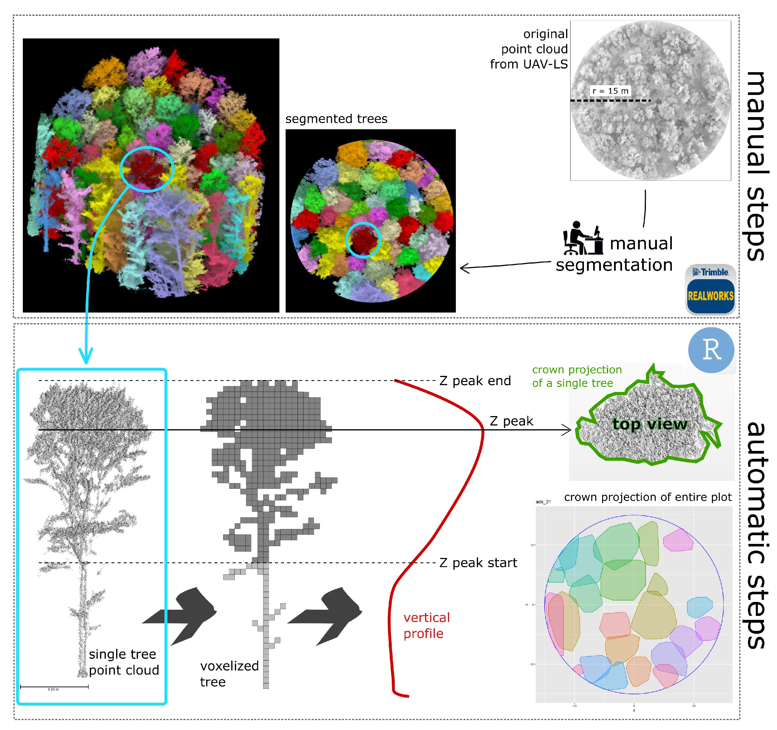
A Semi-Automatic Approach for Tree Crown Competition Indices Assessment from UAV LiDAR
beech forests
individual tree segmentation
precision forestry
size differation index
vertical profile traits
Mostra abstract
Understanding the spatial heterogeneity of forest structure is crucial for comprehending ecosystem dynamics and promoting sustainable forest management. Unmanned aerial vehicle (UAV) LiDAR technology provides a promising method to capture detailed three-dimensional (3D) information about forest canopies, aiding in management and silvicultural practices. This study investigates the heterogeneity of forest structure in broadleaf forests using UAV LiDAR data, with a particular focus on tree crown features and their different information content compared to diameters. We explored a non-conventionally used method that emphasizes crown competition by employing a nearest neighbor selection technique based on metrics derived from UAV point cloud profiles at the tree level, rather than traditional DBH (diameter at breast height) spatial arrangement. About 300 vegetation elements within 10 plots collected in a managed Beech forest were used as reference data. We demonstrate that crown-based approaches, which are feasible with UAV LiDAR data at a reasonable cost and time, significantly enhances the understanding of forest heterogeneity, adding new information content for managers. Our findings underscore the utility of UAV LiDAR in characterizing the complexity and variability of forest structure at high resolution, offering valuable insights for carbon accounting and sustainable forest management. © 2024 by the authors.

Improving Aboveground Biomass Estimation in Beech Forests with 3D Tree Crown Parameters Derived from UAV-LS
Mostra abstract
Accurate estimates of aboveground biomass (AGB) are essential for forest policies to reduce carbon emissions. Unmanned aerial laser scanning (UAV-LS) offers unprecedented millimetric detail but is underutilized in monitoring broadleaf Mediterranean forests compared to coniferous ones. This study aims to design and evaluate a procedure for AGB estimates based on the predictive power of crown features. In the first step, we manually created Quantitative Structure Models (QSMs) for 320 trees using data from UAV laser scanning (UAV-LS), airborne laser scanning (ALS), and co-registered terrestrial laser scanning (TLS). This provided the most accurate non-destructive estimate of aboveground biomass (AGB) in the absence of destructive measurements. For each reference tree we also measured crown projection and crown volume to build two separated models relating AGB to such crown features. In the second phase, we evaluated the potential of UAV-LS for quantifying AGB in a pure European beech (Fagus sylvatica) forest and compared it with traditional ALS estimates, using fully automatic procedures. The two obtained tree-level AGB models were then tested using three datasets derived from 35 sampling plots over the same study area: (a) 1130 trees manually segmented (phase-2 reference); (b) trees automatically extracted from ALS data; and (c) trees automatically extracted from UAV-LS data. Results demonstrate that detailed UAV-LS data improve model sensitivity compared to ALS data (RMSE = 45.6 Mg ha<sup>−1</sup>, RMSE% = 13.4%, R2 = 0.65, for the best ALS model; RMSE = 44.0 Mg ha<sup>−1</sup>, RMSE% = 12.9%, R2 = 0.67, for the best UAV-LS model), allowing for the detection of AGB differences even in quite homogenous forest structures. Overall, this study demonstrates the combined use of both laser scanner data can foster non-destructive and more precise AGB estimation than the use of only one, in forested areas across hectare scales (1 to 100 ha). © 2025 by the authors.
Comparative analysis of taper models for Pinus nigra Arn. using terrestrial laser scanner acquired data
Boukhris
,
Issam
,
Puletti
,
Nicola
,
Vonderach
,
Christian
,
Guasti
,
Matteo
,
Lahssini
,
Said
,
Santini
,
Monia
,
Valentini
,
Riccardo
forest mensuration
b-splines
environmental management
forest as-sessment
max and burkhart
random forest
taper equations
tls
volume equations
Mostra abstract
Taper equations are indispensable tools for characterizing the stem profile of trees, providing valuable insights for forest management, timber inventory, and optimal assortments allocation. The recent progress in Terrestrial Laser Scanning (TLS) has revolutionized forest inventory practices by enabling non-destructive data collection. In this study, four taper models from three different model categories were established based on point cloud data of 219 Pinus nigra trees. The taper equations fitted with TLS data were used to predict the diameter at specific stem heights and the total stem volume. The results show that among fitted models, the Max and Burkhart segmented model calibrated by the means of a mixed-effects approach provided the best estimate of the diameter at different heights and the total stem volume evaluated for different diameter at breast height (DBH) classes. In numerical terms, this model es-timated the diameter and the volume with a respective overall error of 0.781 cm and 0.021 m<sup>3</sup>. The predicted profile also shows that above a relative height of 0.7, the diameter error tends to increase due to the low reliability of data collected beyond the base of the crown primarily caused by interference from branches and leaves. Nevertheless, this study shows that TLS technology presents a compelling opportunity and a promising non-destructive alternative for generating taper profiles and estimating tree volume. © SISEF.
Moths in space: The below-canopy structure of forest drives abundance and mobility-related traits of moth communities
La Cava
,
Sara
,
Rijllo
,
Giuseppe
,
Zucco
,
Giada
,
Innocenti
,
Simone
,
Guasti
,
Matteo
,
Puletti
,
Nicola
,
Ferrara
,
Carlotta
,
Scalercio
,
S.
Mostra abstract
The distribution of species is primarily driven by the availability of trophic resources. In a given forest type, insects trophically related to the dominant tree are expected to be evenly distributed due to the abundance of their foodplant. However, their distribution is also influenced by complex relationships with abiotic and biotic parameters such as available space, predatory pressure, and morphometric traits. In this study, we investigated how the three-dimensional structure of space below the canopy may affect the composition of nocturnal lepidoptera communities. To synthesise the complexity of the dispersal behaviour of these insects, we evaluated easily measurable traits such as wingspan and the presence of tympanic organs, both connected to their mobility and thus potentially influenced by the structure of the available flight space. The study was conducted in the Sila National Park (Italy), where 12 sampling sites were selected in pine forests and an additional 12 in beech forests. Forest spatial structure was investigated using a portable terrestrial laser scanner. Moths were sampled monthly using light traps from May to October in both 2019 and 2020. Among measured forest traits, we observed that the space above three meters from the ground is the only factor influencing community composition. Larger species with tympanic organs prefer environments with less space below tree canopies. Our findings could be the starting point for future studies that investigate a potential defence strategy of moths against bats, as tympanate and larger species not only actively avoid chiropter predation but could also choose denser forests because of a lower bat activity. Moths' distribution and community composition thus appear to be significantly shaped by the spatial structure of forests. © 2024 Elsevier B.V.
A co-registration approach between terrestrial and UAV laser scanning point clouds based on ground and trees features
Mostra abstract
Accurate co-registration of terrestrial and aerial point clouds can provide a high-resolution description of tree components across large forest areas. However, a semi-automatic approach for co-registering point clouds is still needed, given the challenges in geospatial data processing, particularly in complex topographical conditions. The main objective of this study is to present the application of a novel procedure for the co-registration of point clouds obtained from terrestrial and UAV surveys in Mediterranean forests. The proposed methodology proves to be promising and will constitute the basis for experimentation on a larger scale. © 2024 Istituto Sperimentale per la Selvicoltura. All rights reserved.
Mapping Understory Vegetation Density in Mediterranean Forests: Insights from Airborne and Terrestrial Laser Scanning Integration
forest biodiversity
lidar
terrestrial laser scanner
forest structure
spatial prediction
voxelization
Mostra abstract
The understory is an essential ecological and structural component of forest ecosystems. The lack of efficient, accurate, and objective methods for evaluating and quantifying the spatial spread of understory characteristics over large areas is a challenge for forest planning and management, with specific regard to biodiversity and habitat governance. In this study, we used terrestrial and airborne laser scanning (TLS and ALS) data to characterize understory in a European beech and black pine forest in Italy. First, we linked understory structural features derived from traditional field measurements with TLS metrics, then, we related such metrics to the ones derived from ALS. Results indicate that (i) the upper understory density (5–10 m above ground) is significantly associated with two ALS metrics, specifically the mean height of points belonging to the lower third of the ALS point cloud within the voxel (HM<inf>1/3</inf>) and the corresponding standard deviation (SD<inf>1/3</inf>), while (ii) for the lower understory layer (2–5 m above ground), the most related metric is HM<inf>1/3</inf> alone. As an example application, we have produced a map of forest understory for each layer, extending over the entire study region covered by ALS data, based on the developed spatial prediction models. With this study, we also demonstrated the power of hand-held mobile-TLS as a fast and high-resolution tool for measuring forest structural attributes and obtaining relevant ecological data. © 2023 by the authors.
Inference on forest attributes and ecological diversity of trees outside forest by a two-phase inventory
Marchetti
,
Marco
,
Garfì
,
Vittorio
,
Pisani
,
Caterina
,
Franceschi
,
Sara
,
Marcheselli
,
Marzia
,
Corona
,
P.
,
Puletti
,
Nicola
,
Vizzarri
,
Matteo
,
Di Cristofaro
,
Marco
,
Ottaviano
,
Marco
,
Fattorini
,
Lorenzo
Mostra abstract
Key message: Trees outside forests (TOF) have crucial ecological and social-economic roles in rural and urban contexts around the world. We demonstrate that a large-scale estimation strategy, based on a two-phase inventory approach, effectively supports the assessment of TOF’s diversity and related climate change mitigation potential. Context: Although trees outside forest (TOF) affect the ecological quality and contribute to increase the social and economic developments at various scales, lack of data and difficulties to harmonize the known information currently limit their integration into national and global forest inventories. Aims: This study aims to develop and test a large-scale estimation framework to assess ecological diversity and above-ground carbon stock of TOF. Methods: This study adopts a two-phase inventory approach. Results: In the surveyed territory (Molise region, Central Italy), all the attributes considered (tree abundance, basal area, wood volume, above-ground carbon stock) are concentrated in a few dominant species. Furthermore, carbon stock in TOF above-ground biomass is non-negligible (on average: 28.6 t ha<sup>−1</sup>). Compared with the low field sampling effort (0.08% out of 52,796 TOF elements), resulting uncertainty of the estimators are more than satisfactory, especially those regarding the diversity index estimators (relative standard errors < 10%). Conclusion: The proposed approach can be suitably applied on vast territories to support landscape planning and maximize ecosystem services balance from TOF. © 2018, INRA and Springer-Verlag France SAS, part of Springer Nature.
Checking the performance of point and plot sampling on aerial photoimagery of a large-scale population of trees outside forests
Fattorini
,
Lorenzo
,
Puletti
,
Nicola
,
Chirici
,
Gherardo
,
Corona
,
P.
,
Gazzarri
,
C.
,
Mura
,
Matteo
,
Marchetti
,
Marco
tessellation stratified sampling
two-phase sampling
design-based estimation
one-per-stratum stratified sampling
Mostra abstract
The present study investigates some sampling strategies for the estimation of abundance and canopy cover of trees outside forest (TOF) over large areas. A collection of about 53 000 TOF units in Central Italy was acquired by visual, on-screen interpretation of aerial orthophotos and was taken as the reference population with the purpose of investigating: (i) one-phase inventories with sample points located by means of the tessellation stratified sampling (TSS), which involves covering the study region by a grid of regular polygons of equal sizes and randomly and independently selecting a point in each of them; (ii) two-phase inventories with the one-per-stratum stratified sampling adopted in the second phase to select a sample of polygons from the grid and then visit only the points contained in those polygons. Uniform random sampling is also considered in the first phase as a benchmark for tessellation stratified sampling. The sampling schemes adopted to select TOF units at the sample points are as follows: (i) point sampling, (ii) centroid-based plot sampling with plot radius of 50m(CPLS50) or 100 m, and (iii) plot intersect sampling with plot radius of 50 or 100 m. CPLS50 under single-phase TSS proves to be a promising strategy to large-scale TOF inventories. © 2016, Canadian Science Publishing. All rights reserved.
Prediction of forest NPP in Italy by the combination of ground and remote sensing data
Chirici
,
Gherardo
,
Chiesi
,
Marta
,
Corona
,
P.
,
Puletti
,
Nicola
,
Mura
,
Matteo
,
Maselli
,
Fabio
Mostra abstract
Our research group has recently proposed a strategy to simulate net forest carbon fluxes based on the coupling of a NDVI-driven parametric model, Modified C-Fix, and of a biogeochemical model, BIOME-BGC. The outputs of the two models are combined through the use of a proxy of ecosystem distance from equilibrium condition which accounts for the occurred disturbances. This modeling strategy is currently applied to all Italian forest areas using an available set of NDVI images and ancillary data descriptive of an 8-year period (1999–2006). The obtained estimates of forest net primary production (NPP) are first analyzed in order to assess the importance of the main model drivers on relevant spatial variability. This analysis indicates that growing stock is the most influential model driver, followed by forest type and meteorological variables. In particular, the positive influence of growing stock on NPP can be constrained by thermal and water limitations, which are most evident in the upper mountain and most southern zones, respectively. Next, the NPP estimates, aggregated over seven main forest types and twenty administrative regions in Italy, are converted into current annual increment of standing volume (CAI) by specific coefficients. The accuracy of these CAI estimates is finally assessed by comparison with the ground data collected during a recent national forest inventory. The results obtained indicate that the modeling approach tends to overestimate the ground CAI for most forest types. In particular, the overestimation is notable for forest types which are mostly managed as coppice, while it is negligible for high forests. The possible origins of these phenomena are investigated by examining the main model drivers together with the results of previous studies and of older forest inventories. The implications of using different NPP estimation methods are finally discussed in view of assessing the forest carbon budget on a national basis. © 2015, Springer-Verlag Berlin Heidelberg.
Harmonized forest categories in central Italy
Chiavetta
,
U.
,
Camarretta
,
Nicolò
,
Garfì
,
Vittorio
,
Ottaviano
,
Marco
,
Chirici
,
Gherardo
,
Vizzarri
,
Matteo
,
Marchetti
,
Marco
Mostra abstract
To support sustainable forest management, planning policies and environmental actions, it is essential to have available common and standardized geospatial information on forest structure, composition and distribution. In this paper we present a harmonized forest categories (HFCs) map of four administrative Regions located in central Italy (i.e. Marche, Abruzzo, Lazio and Molise) at a scale of 1:400,000. The study area extends over 42,246 km<sup>2</sup>, 14,878 km<sup>2</sup> of which are covered by forests. Four regional forest maps were harmonized in order to produce common standardized information on composition, structure and the distribution of forests in central Italy. A forest category is a forest vegetation unit defined by the main tree species composition. In this study we adopted a nomenclature scheme composed of 16 forest and shrubland categories. This work represents the first HFCs map in Italy over a large area. The legend is also harmonized with the European Environment Agency forest types nomenclature. © 2016 Nicolò Camarretta.
Relating forest structural characteristics to bat and bird diversity in the Italian Alps
Rigo
,
Francesca
,
Paniccia
,
Chiara
,
Anderle
,
Matteo
,
Chianucci
,
Francesco
,
Obojes
,
Nikolaus
,
Tappeiner
,
Ulrike
,
Hilpold
,
Andreas
,
Mina
,
Marco
Mostra abstract
The global decline of biodiversity has affected European forests, involving many tree species and forest-dwelling threatened animals. An integrated approach linking forest structure and multi-taxon diversity is increasingly needed to maintain the multifunctionality of forest ecosystems. We investigated the relationship between forest structure, deadwood elements, canopy attributes, and tree-related microhabitats on bat and bird communities in the north-eastern Italian Alps. We collected forest attributes, bats, and bird data on 40 forest plots encompassing the diversity of forest types. To assess the different contributions of each forest attribute variables we performed a two-step statistical analysis using generalised and linear models, including bat and bird taxonomical and functional diversity indices as response variables. Our findings reveal that bats and birds respond differently to variation in forest structural characteristics. Specifically, bat species richness was higher in forests with both higher standing tree and lying deadwood volume. The Shannon diversity index for bird community was higher in forests with high volumes of coarse lying deadwood and stumps. Moreover, plots with mature trees, gaps, and heterogeneous diameter distribution fostered the presence of generalist species of bats and birds, while the abundance of tree-related microhabitats was not significant for these two taxa. This study demonstrates that the optimal habitat conditions for bats and birds in Alpine forests are multifaceted. Promoting distinctive elements within forest stands and a complex forest structure through adaptations in forest management interventions would enhance the conservation of multi-taxon forest biodiversity. © 2024 The Authors
Mapping forest ecosystem functions for landscape planning in a mountain Natura2000 site, Central Italy
sustainable forest management
forest ecosystem functions
forest landscape management planning
k-nn
multi-criteria and multi-level approach
Mostra abstract
In last decades, numerous efforts have been carried out by the scientific community to assess the multifunctional role of forests in supporting the forest decision-making processes. Recently developed in Italy, the Forest Landscape Management Planning seems to be the most suitable tool to maintain the sustainability balance between forests and local populations. This research identifies and maps different forest ecosystem functions in a mountain Natura2000 Network site by performing a spatial estimation of forest inventory parameters, and implementing a multi-criteria and multi-level approach. Final results on mapping of forest functions show acceptable values of classification accuracy. © 2014 University of Newcastle upon Tyne.
Comparing multisource harmonized forest types mapping: A case study from central italy
Vizzarri
,
Matteo
,
Chiavetta
,
U.
,
Chirici
,
Gherardo
,
Garfì
,
Vittorio
,
Bastrup-Birk
,
Annemarie M.
,
Marchetti
,
Marco
central italy
forest area estimation
forest categories
forest nomenclature systems
forest resources classification
forest resources mapping
forest types
Mostra abstract
The availability of common standardized geospatial information on composition, structure and distribution of forests is essential to support environmental actions, sustainable forest management and planning policies. Forest types maps are suitable tools for supporting both silvicultural and forest planning choices from local to global scale levels. For this reason local authorities may develop forest types maps independently, in which case a standardized/harmonized framework for their comparison and aggregation is essential. At the same time local forest types maps may not be directly related to pan-European forest resources assessments and classification systems. This paper presents results of the harmonization of four forest types maps available for central Italy. The process is based on a bottom-up approach aimed at maintaining the most detailed common nomenclature system across the different Regions. The final results, in terms of forest types area, are compared with several independent sources of information: (i) two forest maps, one developed at national level on the basis of the Corine Land Cover 2006, and one for high resolution forest/non forest classification developed at pan-European level; and (ii) two sample based inventories: the Italian National Forest Inventory (INFC) and the Italian Land Use Inventory (IUTI). The results show that the proposed bottomup harmonization approach is a suitable tool to guarantee the integrity and homogeneity of local forest types nomenclature systems, and to integrate such local data with European standards. ©iForest – Biogeosciences and Forestry