Loading...
Pubblicazioni Scientifiche
Filtri di ricerca 48 risultati
Pubblicazioni per anno
A Semi-Automatic Approach for Tree Crown Competition Indices Assessment from UAV LiDAR
beech forests
individual tree segmentation
precision forestry
size differation index
vertical profile traits
Mostra abstract
Understanding the spatial heterogeneity of forest structure is crucial for comprehending ecosystem dynamics and promoting sustainable forest management. Unmanned aerial vehicle (UAV) LiDAR technology provides a promising method to capture detailed three-dimensional (3D) information about forest canopies, aiding in management and silvicultural practices. This study investigates the heterogeneity of forest structure in broadleaf forests using UAV LiDAR data, with a particular focus on tree crown features and their different information content compared to diameters. We explored a non-conventionally used method that emphasizes crown competition by employing a nearest neighbor selection technique based on metrics derived from UAV point cloud profiles at the tree level, rather than traditional DBH (diameter at breast height) spatial arrangement. About 300 vegetation elements within 10 plots collected in a managed Beech forest were used as reference data. We demonstrate that crown-based approaches, which are feasible with UAV LiDAR data at a reasonable cost and time, significantly enhances the understanding of forest heterogeneity, adding new information content for managers. Our findings underscore the utility of UAV LiDAR in characterizing the complexity and variability of forest structure at high resolution, offering valuable insights for carbon accounting and sustainable forest management. © 2024 by the authors.

Estimating tree diversity in forest ecosystems by two-phase inventories
Corona
,
P.
,
Fattorini
,
Lorenzo
,
Franceschi
,
Sara
,
Marcheselli
,
Marzia
,
Pisani
,
Caterina
,
Chiavetta
,
U.
,
Puletti
,
Nicola
Mostra abstract
Several studies reveal that there is a strong interconnection between climate change and biodiversity. Indeed, estimating plant biodiversity is an important issue under forest ecosystem monitoring, which allows the evaluation of carbon storage and sequestration capacity. To this end, a two-phase strategy, suitably compatible with the most adopted sampling designs in large-scale forest inventories, is proposed. In the first phase, tessellation stratified sampling is performed by partitioning the study area into a grid of quadrats and by randomly selecting a point in each quadrat. The first-phase points are classified as forest or nonforest using remotely sensed imagery. In the second phase, a sample of points is selected from those classified as forest by means of simple random sampling without replacement. The second-phase points constitute the centers of circular plots that are visited in the field to record plant species (usually trees) and their abundance. Estimators of abundance and diversity and estimators of their variances are presented. The proposed strategy is applied in a forest area from Central Italy, as a case study. With respect to the sampling effort, the resulting estimates of relative standard errors are satisfactory, especially those regarding the overall total and diversity index estimators. The proposed statistical approach represents a suitable reference for integrated forest inventory frameworks effectively supporting biodiversity monitoring and assessment. © 2018 John Wiley & Sons, Ltd.
Quantitative changes of forest landscapes over the last century across Italy
Mostra abstract
A key topic in landscape ecology and vegetation science is the quantitative analysis of changes in forest cover over time, through the use of geomatics monitoring tools. Ecologists and landscape researchers are pointing out that a full understanding of ecosystems and landscapes should be based on the analysis of their functioning over long time series. Under this perspective, a long-term historical reconstruction of forest cover is essential. This study has aimed at examining the long-term dynamics of forest landscapes in Italy, over the last century, using recent remote-sensing based map (2012) and an accurate historical map (1936). A forest-non forest approach has been followed by the computation of a variety of landscape metrics using two analysis tools, with the final objective of quantifying changes in forest cover patterns and in the composition of specific landscape elements. Results show that forest landscape structure has significantly changed across Italy, resulting in a general trend of decreasing fragmentation and patchiness, mainly through enlargement of existing forest patches, which have also assumed a more geometrically regular shape. In relative terms, the greatest expansion of forest areas has occurred mainly in lowland districts characterised by the highest level of human pressure in the country. © 2017 Società Botanica Italiana.
Photographic assessment of overstory and understory leaf area index in beech forests under different management regimes in Central Italy: Short communication
Mostra abstract
Forest understory may be strongly affected by silvicultural practices such as thinning, which simultaneously modulates the overstory canopy cover and influences the availability of light. However, the understory layer is rarely considered in management decisions, partly because methods to estimate understory leaf area index are poorly developed. In this study we used two different restricted view angle photographic methods to estimate overstory plant area index L<inf>O</inf> (zenith cover photography), understory leaf area index L<inf>U</inf> (nadir cover photography) and their related canopy attributes (foliage clumping, foliage cover, crown cover, crown porosity). These measurements were performed in beech stands under different management regime. Results from photography indicated that not only overstory but also understory canopy attributes were significantly influenced by forest management. In addition, a significant negative correlation was found between L<inf>O</inf> and L<inf>U</inf>. We conclude that the photographic methods are effective for monitoring (overstory and understory) canopy status in managed stands, on account of their rapid and not destructive procedures, which allows large scale implementation of the methods. © 2014 Estonian University of Life Sciences. All rights reserved.
Early impact of alternative thinning approaches on structure diversity and complexity at stand level in two beech forests in Italy
Becagli
,
Claudia
,
Puletti
,
Nicola
,
Chiavetta
,
U.
,
Cantiani
,
Paolo
,
Salvati
,
Luca
,
Fabbio
,
Gianfranco
Mostra abstract
Stand structure, tree density as well as tree spatial pattern define natural dynamics and competition process. They are therefore parameters used to define any silvicultural management type. This work aims to report first data resulting from a silvicultural experiment in beech forests. The objective of the trial is testing the structure manipulation in terms of diversity and the reduction of inter-tree competition of different thinning approaches. Alternative thinning methods have been applied in two independent experimental sites located in the pre-Alps and southern Apennines, in Italy. Specific goals were to: (i) verify the impact early after thinning implementation on forest structure through a set of diversity and competition metrics resulting from a literature review; (ii) the sensitivity of tested indexes to detect effectively thinning manipulation. Main results show the low sensitivity of stand structure indexes and the ability of competition metrics to detect thinning outcome.
How different thinning can improve carbon sequestration, carbon stock and mechanical stability in peri-urban mixed forest stands: a study case in Mediterranean environment
Mostra abstract
Peri-urban plantations in the Mediterranean are often degraded due to human inactivity and climate change, leading to a loss of ecosystem services and biodiversity. This study investigates the impact of different thinning practices on carbon sequestration and tree stability in a degraded peri-urban plantation in the Italian Apennines, six years after thinning. Three treatments were compared: (a) moderate thinning from below (− 25% biomass), representing the typical practice; (b) intense selective thinning (-35% biomass), representing an innovative approach; and (c) no management as the control. Growth projections were used to estimate carbon recovery for these treatments, based on site-specific models calibrated with real data. The results show that both thinning approaches increased carbon sequestration over time, with the innovative thinning achieving a 7% higher annual carbon sequestration rate than traditional thinning and 8% more than the control. Estimated payback times were 9 years for recovering the harvested volume in both thinning approaches, 10 years for innovative thinning to surpass traditional thinning, 17 years for innovative thinning to surpass the control, and 24 years for traditional thinning to surpass the control. Additionally, tree mechanical stability improved significantly in both thinning treatments after two years, with further increases observed in the innovative thinning group after six years. These results suggest that selective thinning can accelerate forest recovery and carbon sequestration, especially in areas with high stem density, where it can reduce the negative impacts of tree mortality and deadwood accumulation. However, careful planning is required to mitigate potential short-term stability issues, particularly in challenging environments (e.g., windy conditions, steep slopes). Forest management strategies should therefore aim to balance growth, carbon storage, and tree stability, considering both long-term sustainability and local environmental conditions. The findings are particularly relevant for current climate change mitigation strategies, emphasizing that thinning should be carefully tailored to forest type and conditions to maximize benefits in carbon credit generation and sustainable forest management practices. © Northeast Forestry University 2025.
Mapped tree dataset of public green areas in the Municipality of Arezzo, Tuscany (Italy)
Chianucci
,
Francesco
,
Sansone
,
Dalila
,
Lazzerini
,
Giada
,
Tiberi
,
Gioele
,
Cristina Monteverdi
,
Maria
,
Chiavetta
,
U.
Mostra abstract
The dataset reports data from more than 9,000 trees, which were sampled in 2024-2025 to create a first urban tree inventory of public green areas in the Municipality of Arezzo. For each tree, spatial position, species, diameter were sampled in different public green space types. Data are available as table and spatial vector layer. Data can support urban planners and managers for assessing the state-of-the-art of urban greening, supporting tree management practices and monitoring, feeding urban tree models and calibrating remotely-sensed information. Non-spatial and spatial metrics can be derived to assess the diversity of urban tree spaces to implement sustainable urban greening practices. © 2025 Istituto Sperimentale per la Selvicoltura. All rights reserved.
Enhancing scientific publishing in the field of silviculture
What Is Known About the Management of European Beech Forests Facing Climate Change? A Review
Antonucci
,
Serena
,
Santopuoli
,
Giovanni
,
Marchetti
,
Marco
,
Tognetti
,
Roberto
,
Chiavetta
,
U.
,
Garfì
,
Vittorio
Mostra abstract
Purpose of Review: This paper aims to retrace the most significant management strategies adopted across European beech forests over the last 25 years, highlighting those that are most efficient and promising. We investigate five main topics including forest management, forest models, species mixture, genetic, and regeneration. Recent Findings: European beech is one of the most widespread and important tree species for the European forest sector. In the light of the ongoing climate crisis, understanding the growth dynamics and the response of beech forests to climate change is crucial to identify advantageous management strategies. Ecology, growth, management, distribution, interaction with other species, genetic, and regeneration aspects of European beech were investigated in different geographical areas of Europe. Despite recent researches focusing on climate change issues, how adaptation and mitigation measures can be integrated into silvicultural guidelines to improve the resilience of European beech forests remains unclear. Summary: To answer this question, we collected and reviewed articles about the management of European beech facing climate change, which were published in peer-reviewed journals over the last 25 years. Articles were grouped into five geographic European areas, according to the classification used by the State of Europe’s forests. Obtained articles were further clustered into five main topics: management, mixed forest, modelling, genetic, and regeneration. The review highlighted the importance of using long-term monitoring plots to understand the effect of climate change on the stability of European beech forests, suggesting climate-smart measures that would help these forests adapt to climate change. © 2021, The Author(s), under exclusive licence to Springer Nature Switzerland AG.
foreMast: an R package for predicting beech (Fagus sylvatica L.) masting events in European countries
forest management
climatic cues
fagus sylvatica l. (european beech)
mast event
r package
seed production
Mostra abstract
Key message: Forecasting annual seed production will improve the management of forests across Europe. The foreMast R package we developed predicts current year masting probability in beech (Fagus sylvatica L.) using climate data easily accessible by any stakeholder. Context: Modelling and predicting forest masting is one of the most challenging tasks in forest management, as it is a strategy shared by several species, very important for tree dispersion and forest regeneration, mainly related to climate and ecological processes. Aims: As many studies focus on European beech (Fagus sylvatica L.) masting without simple practical implementations, we developed a tool capable of predicting beech masting years. Methods: The tool is an R package (foreMast) made by three functions, which relies mainly on climate data. The algorithm performance is compared with the records of the MASTREE database, which gather several beech seed production series for various sites across European countries. Results: Overall, the results show a tight correlation with the compared sites (ρ = 0.50 to 0.61, p-value < 0.0001, respectively), especially when temperatures weigh three times more than precipitation. Nevertheless, in some sites, seed production seems to be more related to precipitation dynamics than to temperatures. Conclusion: foreMast can be used both for studying changes in mast events in relation to climate changes and in operative forest management and planning. It is flexible and thus amenable to future implementation of additional predicting variables or target species. © 2021, INRAE and Springer-Verlag France SAS, part of Springer Nature.
A multi-criteria analysis of forest restoration strategies to improve the ecosystem services supply: an application in Central Italy
Paletto
,
Alessandro
,
Pieratti
,
Elisa
,
De Meo
,
Isabella
,
Agnelli
,
Alessandro Elio
,
Cantiani
,
Paolo
,
Chiavetta
,
U.
,
Mazza
,
Gianluigi
,
Lagomarsino
,
Alessandra
carbon sequestration
carbon stock
biophysical assessment
economic evaluation
multiple-criteria decision analysis (mcda)
recreational activities
Mostra abstract
• Key message: A multi-criteria analysis can be an interesting tool to assess the effects of silvicultural treatments on ecosystem services supply. In the degraded forests, thinning has a positive effect on the provision of ecosystem services such as timber and bioenergy production, climate change mitigation, and recreational attractiveness. • Context: The Millennium Ecosystem Assessment highlights the importance of the ecosystem services for human well-being and for maintaining conditions for life on Earth. Silvicultural treatments can improve the provision of ecosystem services to increase local communities’ well-being. • Aims: The aim of this study is to understand the effects of two-forest restoration practices (selective thinning and thinning from below) on three ecosystem services (wood production, climate change mitigation, and recreational opportunities) in an Italian case study. • Methods: A multi-criteria decision analysis (MCDA) was performed to compare the effects of three forest restoration scenarios (baseline, selective thinning, thinning from below) on ecosystem services. Wood production was estimated considering the local market prices and the wood volumes harvested, while climate change mitigation was quantified through the C-stock and C-sequestration changes in carbon pools due to the silvicultural treatments. The recreational activities were assessed through a questionnaire survey. A sample of 200 visitors was interviewed face-to-face to estimate the impact of thinning on recreational activities. • Results: The results of the MCDA show that the selective thinning scenario is the optimal forest restoration practice to increase the recreational attractiveness and the wood production in the study area. • Conclusion: The results concerning the effects of the silvicultural treatments on ecosystem services supply are an important tool to support decision makers. © 2021, INRAE and Springer-Verlag France SAS, part of Springer Nature.
Comparison of TLS against traditional surveying method for stem taper modelling. A case study in European beech (Fagus sylvatica L.) forests of mount Amiata
Torresan
,
C.
,
Pelleri
,
F.
,
Manetti
,
Maria Chiara
,
Becagli
,
Claudia
,
Castaldi
,
Cristiano
,
Notarangelo
,
Monica
,
Chiavetta
,
U.
Mostra abstract
Traditionally, taper equations are developed from measurements collected through a destructive sampling of trees. Terrestrial laser scanning (TLS) enables high levels of accuracy of individual tree parameters measurement avoiding tree felling. With this study, we wanted to assess the performance of two approaches to calibrate a taper function: using stem diameters extracted from TLS point clouds and measured at different tree heights with the traditional and usual forest instruments. We compared the performance of four taper equations built with data collected by TLS and traditional survey in a European beech (Fagus sylvatica L.) forests of mount Amiata (Tuscany Region, Italy). We computed the volume of stem sections 1.00 m long by integrating the most performing TLS-based taper equation and by the Huber, Smalian and cone formulas applied on the diameter and height values measured with the traditional field surveys. We conducted the analysis of error distribution in volume estimates computed integrating the most performing TLS-based taper function along the stem. We tested if the differences in the volume estimate of the two methods were significant. Schumacher and Hall (1933) equation was the most performing taper function both in case of using TLS and traditional surveyed data, being the TLS-based function more performant (rRMSE = 6.90% vs 9.17%). Its performance did not increase when diameter values were extracted from TLS point clouds with a higher frequency (i.e. 25.0 cm vs 1.00 m). By integrating the TLS-based Schumacher and Hall (1933) function, the sections with the highest error resulted from 5.00 to 7.00 m of stem height (i.e. RMSE from 14.72 to 19.14 dm<sup>3</sup> and rRMSE from 13.00 to 17.76%). This study case represents the first attempts to develop a taper equation for European beech of mount Amiata using values of stem diameter and height extracted from the TLS point cloud. The results demonstrated that TLS produces the same stem volume estimates as traditional method avoiding falling trees. © 2021 Centro di Ricerca per la Selvicoltura, Consiglio per la Ricerca in Agricoltura e l'Analisi dell'Economia Agraria. All rights reserved.
Monitoring spring phenology in Mediterranean beech populations through in situ observation and Synthetic Aperture Radar methods
Proietti
,
R.
,
Antonucci
,
Serena
,
Monteverdi
,
Maria Cristina
,
Garfì
,
Vittorio
,
Marchetti
,
Marco
,
Plutino
,
Manuela
,
Di Carlo
,
Marco
,
Germani
,
Andrea
,
Santopuoli
,
Giovanni
,
Castaldi
,
Cristiano
,
Chiavetta
,
U.
Mostra abstract
The interest in tree phenology monitoring is increasing because this trait is a robust indicator of the impacts of climate change on natural and managed ecosystems. Different approaches to monitor phenology at different spatial scales, from in situ monitoring to remote sensing, are used to investigate spring and/or autumn phenological changes. In Mediterranean area, most of phenological changes occur during cloudy periods (spring and autumn), leading to a loss of information also for very high temporal resolution satellites. Instead, cloud-uninfluenced sensors, such as radar sensors, can allow to bypass this problem and produce a temporally continuous coverage. In this paper, we analyzed the spring phenology of two European beech (Fagus sylvatica L.) populations, located at different latitudes in Mediterranean area. Weekly in situ monitoring of leaf-out has been correlated with data collected by Synthetic Aperture Radar. Spring phenological phases were monitored in situ following a modified BBCH-code with a 5-scores scale (from 1 - buds closed and covered by scales, to 5 - leaf completely unfolded). The score 3 (young leaves starting to emerge from the bud) was considered the bud break. Different site conditions based on aspect (northern and southern) and altitudinal gradient (high and low altitude) have been considered. The aim was to test and implement a new methodology able to decrease the frequency of the field sampling, using remote data, to extend more detailed information on geographical scale, and to reconstruct past phenology. Results showed a statistically significant different length of the vegetative spring period, spanning from dormant buds, up to leaves completely unfolded, between sites. Through Synthetic Aperture Radar estimation, this study demonstrates that leaf-out can be monitored with an extreme accuracy. The phenophase score 4 and 5 estimation showed the best performance (RMSE < of 4 days), phenophases score 2 and 3 showed promising performances (4 days < RMSE <5 days), while phenophases score 1 seems to be not easily detectable, although it can be extrapolated with an RMSE <6 days. This radar approach fixes the cloud problem typical of multispectral approach and very frequent in phenophase change periods in Mediterranean climate. This study promotes the proposed remote sensing approach as a very useful tool to monitor growing season starting in remote areas, helping to reduce in situ observations and allowing past phenology reconstruction. © 2020 Elsevier Inc.
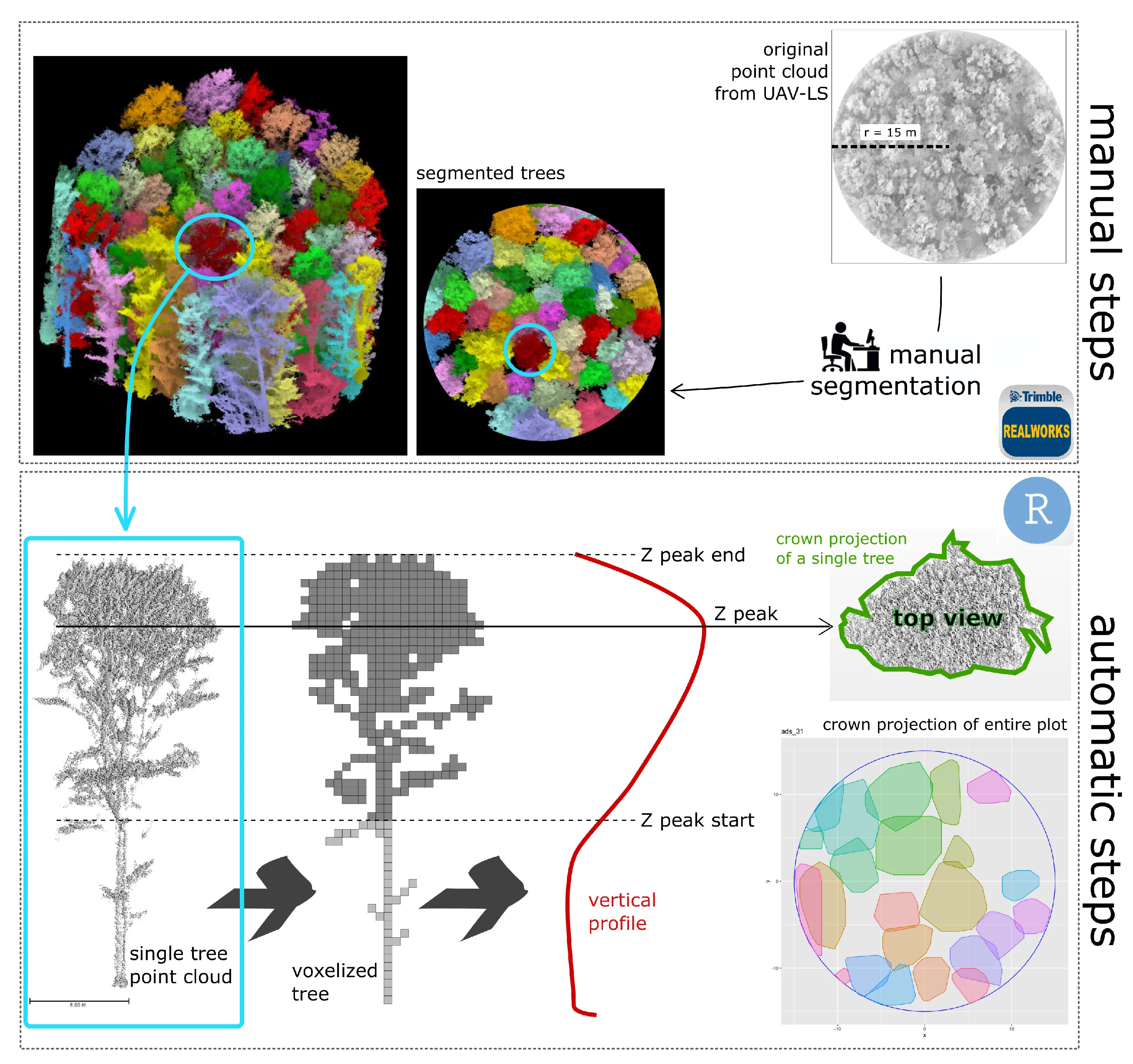
Individual tree crown segmentation in two-layered dense mixed forests from uav lidar data
Torresan
,
C.
,
Carotenuto
,
Federico
,
Chiavetta
,
U.
,
Miglietta
,
F.
,
Zaldei
,
Alessandro
,
Gioli
,
Beniamino
forest inventory
detection rate
itc detection algorithms
itcsegment package
laser scanning
lidr package
parameter calibration
Mostra abstract
In forests with dense mixed canopies, laser scanning is often the only effective technique to acquire forest inventory attributes, rather than structure-from-motion optical methods. This study investigates the potential of laser scanner data collected with a low-cost unmanned aerial vehicle laser scanner (UAV-LS), for individual tree crown (ITC) delineation to derive forest biometric parameters, over two-layered dense mixed forest stands in central Italy. A raster-based local maxima region growing algorithm (itcLiDAR) and a point cloud-based algorithm (li2012) were applied to isolate individual tree crowns, compute height and crown area, estimate the diameter at breast height (DBH) and the above ground biomass (AGB) of individual trees. To maximize the level of detection rate, the ITC algorithm parameters were tuned varying 1350 setting combinations and matching the segmented trees with field measured trees. For each setting, the delineation accuracy was assessed by computing the detection rate, the omission and commission errors over three forest plots. Segmentation using itcLiDAR showed detection rates between 40% and 57%, while ITC delineation was successful at segmenting trees with DBH larger than 10 cm (detection rate ~78%), while failed to detect trees with smaller DBH (detection rate ~37%). The performance of li2012 was quite lower with the higher detection rate equal to 27%. Errors and goodness-of-fit between field-surveyed and flight-derived biometric parameters (AGB and tree height) were species-dependent, with higher error and lower r<sup>2</sup> for shorter species that constitute the lowermost layer of the forest. Overall, while the application of UAV-LS to delineate tree crowns and estimate biometric parameters is satisfactory, its accuracy is affected by the presence of a multilayered and multispecies canopy that will require specific approaches and algorithms to better deal with the added complexity. © 2020 by the authors. Licensee MDPI, Basel, Switzerland.
Short-term effects of thinning on soil CO2, N2O and CH4 fluxes in Mediterranean forest ecosystems
Mazza
,
Gianluigi
,
Agnelli
,
Alessandro Elio
,
Cantiani
,
Paolo
,
Chiavetta
,
U.
,
Doukalianou
,
Foteini
,
Kitikidou
,
Kyriaki G.
,
Milios
,
Elias
,
Orfanoudakis
,
Michail Z.
,
Radoglou
,
Kalliopi M.
,
Lagomarsino
,
Alessandra
forest floor
global warming potential
green-house gas fluxes
pine plantations restoration
soil moisture
soil temperature
Mostra abstract
In Mediterranean ecosystems an increasing demand for in situ trace gas exchange data is emerging to enhance the adaptation and mitigation strategies under forest degradation. Field-chamber green-house gas fluxes and site characteristics were analysed in two Mediterranean peri-urban pine forests showing degradation symptoms. We examined the effect of different thinning interventions on soil CO<inf>2</inf>, CH<inf>4</inf> and N<inf>2</inf>O fluxes, addressing the relationships with the environmental variables and C and N contents along forest floor-soil layers. Soil temperature resulted as the main driving variable for CO<inf>2</inf> efflux and CH<inf>4</inf> uptake. Soil moisture content and organic matter availability affected CO<inf>2</inf> emission patterns in the two sites. N<inf>2</inf>O fluxes showed a positive correlation with soil moisture under wetter climatic conditions only. GHG fluxes showed significant correlations with C and N content of both forest floor and mineral soil, especially in the deepest layers, suggesting that it should be considered, together with environmental variables when accounting GHG fluxes in degraded forests. Short-term effects of thinning on CO<inf>2</inf> emissions were dependent on disturbance induced by logging operations and organic matter inputs. After thinning CH<inf>4</inf> uptake increased significantly under selective treatment, independently from specific site-induced effects. N<inf>2</inf>O fluxes were characterized by low emissions in both sites and were not affected by treatments. Soil CO<inf>2</inf> efflux was the largest component of global warming potential (GWP) from both sites (11,553 kg ha<sup>−1</sup> y<sup>−1</sup> on average). Although it has a large global warming potential, N<inf>2</inf>O contribution to GWP was about 131 kg CO<inf>2</inf>eq ha<sup>−1</sup> y<sup>−1</sup>. The contribution of CH<inf>4</inf>-CO<inf>2</inf> equivalent to total GWP showed a clear and significant CH<inf>4</inf> sink behaviour under selective treatment (36 kg ha<sup>−1</sup> y<sup>−1</sup> on average). However, in the short-term both thinning approaches produced a weak effect on total GWP. © 2018 Elsevier B.V.
Exploratory analysis of structural diversity indicators at stand level in three Italian beech sites and implications for sustainable forest management
Bertini
,
Giada
,
Becagli
,
Claudia
,
Chiavetta
,
U.
,
Ferretti
,
Fabrizio
,
Fabbio
,
Gianfranco
,
Salvati
,
Luca
silviculture
forest diversity
multiway factor analysis
structural diversity indicators
tree stand structure
Mostra abstract
The present study introduces an exploratory data analysis based on structural indicators with the aim to assess the effect of silvicultural practices on tree stand structure. The study was carried out in three Italian beech forests of different ages with stand structures that originated from dissimilar regeneration and cultivation techniques (Cansiglio, northern Italy, Chiarano, central Italy, and Mongiana, southern Italy). Ten structural indicators were considered when investigating the latent multivariate relationship between stand structure attributes before and after thinning operations by using a multiway factor analysis (MFA). The MFA results identified the older stand at Cansiglio as more homogeneous for cultivation regimes, and more stable to practices when compared with the younger sites (Chiarano and Mongiana). Heterogeneous stands were sensitive to silvicultural practice thus suggesting their possible impact on forest attributes. The proposed approach proved to be an operational tool to evaluate comprehensively the response of forest structure to planned interventions. © 2018, Northeast Forestry University and Springer-Verlag GmbH Germany, part of Springer Nature.
Indicators for the assessment and certification of cork oak management sustainability in Italy
Pollastrini
,
M.
,
Chiavetta
,
U.
,
Cutini
,
Andrea
,
Casula
,
Antonio
,
Maltoni
,
Sara
,
Dettori
,
Sandro
,
Corona
,
P.
italy
forest management planning
non-wood forest products
quercus suber
sardinia
sustainable forest management
Mostra abstract
Sustainable forest management (SFM) is crucial for forest ecosystem productivity and conservation, especially in systems such as cork oak (Quercus suber L.) threatened by human activities and biotic and abiotic factors. In this study SFM indicators with particular reference to cork oak forests in the region of Sardinia (Italy) are proposed and tested. Sustainable and responsible management options specifically aimed at cork oak forest management and chain of custody certification are also provided. A set of ten indicators was proposed and assessed by an expert panel in cork oak management. Five indicators were also tested against data on structure, origin, health condition and management in 285 forest compartments managed by FoReSTAS (Regional Forest Agency for Land and Environment of Sardinia, Italy), including 361 sampling plots and 5345 trees. In order to investigate the priorities and perceptions of SFM experts and stakeholders, a survey was also carried out by completion of a questionnaire on the technical issues of cork oak woodland management. The survey results highlighted a need to improve environmental and economic performance by means of SFM and certification. The indicators tested in Sardinian cork oak woodlands showed that about 80% of the stands fulfilled management sustainability requirements. The suggested SFM indicators can effectively support proactive management and conservation measures, representing a valuable tool in the current context of growing environmental and socioeconomic awareness. © SISEF.
Intra-annual raw basal area increments (early-wood and late-wood) of Pinus nigra subsp. laricio Poiret trees from southern Italy at the pines׳ mesic to xeric distribution range
Mazza
,
Gianluigi
,
Sarris
,
Dimitrios
,
Chiavetta
,
U.
,
Ferrara
,
Rossana Monica
,
Rana
,
Gianfranco
forestry
annual growth
basal-area increments
black pines
even-aged forest stands
growth response
narrow distribution
p. nigra
pinus nigra
southern italy
tree ring data
wood
Mostra abstract
This article contains tree rings data related to the research article entitled “An intra-stand approach to identify intra-annual growth responses to climate in Pinus nigra subsp. laricio Poiret trees from southern Italy” (Mazza et al., 2018). Most dendroclimatological studies on black pine have been conducted on the P. nigra subsp. nigra, while only few results on climate-growth relationships are available for other taxa such as P. nigra subsp. laricio, which has the narrowest distribution range of the collective species P. nigra. This data article provides tree rings data for the subsp. laricio at an intra-annual growth level, distinguishing early-wood (EW) and late-wood (LW), from an even aged forest stand from the Sila mountain area within the subspecies mesic to xeric distribution range. © 2018
An intra-stand approach to identify intra-annual growth responses to climate in Pinus nigra subsp. laricio Poiret trees from southern Italy
Mazza
,
Gianluigi
,
Sarris
,
Dimitrios
,
Chiavetta
,
U.
,
Ferrara
,
Rossana Monica
,
Rana
,
Gianfranco
climate-growth relationships
mediterranean pine forests
standardization methods
tree rings analysis
water utilization
Mostra abstract
The growth of Pinus nigra tree stands is known to be limited by spring-summer precipitation (P). We explored the intra-annual growth dynamics (early-wood EW and late-wood LW of tree-rings) and their responses to climate (in monthly, seasonal and annual scale) in Pinus nigra subsp. laricio at the intra-stand level in Calabria, at the pines' mesic to xeric distribution range. We used a variety of age detrending methods to assess how the adaptive potential to climate change of each tree varies within the even-aged forest stand. In years of wet climate, when precipitation (P) could infiltrate deeper below ground, higher growth rates occurred in 83% of trees, best explained by P accumulated over several previous years. The variability of EW increment was best explained by 3–5 previous year P (including the growth year) in 61% of trees, while LW increment was best explained by 1–3 year P in 78% of trees. This would suggest that in wet years most trees utilized not only surface but also deeper moisture pools using their taproot to produce both EW and LW. In contrast, during dry years, for 39% of trees the most significant predictor for EW was June rainfall. August P explained LW variability in 35% of the trees, while the influence of 1–3 year P on LW was reduced to 48%. Thus, under a drier climate ca. 1/3 of the trees within the stand significantly reduced their capacity to utilize deeper ground moisture, indicating higher vulnerability to drought stress. Multiple-year P appeared as the main climatic driver for growth in most trees, but only became evident through age detrending methods retaining low frequency growth variability. Our findings are the first to provide such insight into the wide spectrum of climatic factors that may drive P. laricio's inter-stand and inter-annual productivity. They also assist to identify the most vulnerable trees to drought stress within a forest stand. Such information could prove very useful in the application of silvicultural treatments (e.g., selective thinning) aiming to increase the resilience of tree stands to future drought intensification. © 2018 Elsevier B.V.
Sustainable land management, adaptive silviculture, and new forest challenges: Evidence from a latitudinal gradient in Italy
Fabbio
,
Gianfranco
,
Cantiani
,
Paolo
,
Ferretti
,
Fabrizio
,
Di Salvatore
,
Umberto
,
Bertini
,
Giada
,
Becagli
,
Claudia
,
Chiavetta
,
U.
,
Marchi
,
Maurizio
,
Salvati
,
Luca
Mostra abstract
Aimed at reducing structural homogeneity and symmetrical competition in even-aged forest stands and enhancing stand structure diversity, the present study contributes to the design and implementation of adaptive silvicultural practices with two objectives: (1) preserving high wood production rates under changing environmental conditions and (2) ensuring key ecological services including carbon sequestration and forest health and vitality over extended stand life-spans. Based on a quantitative analysis of selected stand structure indicators, the experimental design was aimed at comparing customary practices of thinning from below over the full standing crop and innovative practices of crown thinning or selective thinning releasing a pre-fixed number of best phenotypes and removing direct crown competitors. Experimental trials were established at four beech forests along a latitudinal gradient in Italy: Cansiglio, Veneto; Vallombrosa, Tuscany; Chiarano, Abruzzo; and Marchesale, Calabria). Empirical results indicate a higher harvesting rate is associated with innovative practices compared with traditional thinning. A multivariate discriminant analysis outlined significant differences in post-treatment stand structure, highlighting the differential role of structural and functional variables across the study sites. These findings clarify the impact of former forest structure in shaping post-treatment stand attributes. Monitoring standing crop variables before and after thinning provides a basic understanding to verify intensity and direction of the applied manipulation, the progress toward the economic and ecological goals, as well as possible failures or need for adjustments within a comprehensive strategy of adaptive forest management. © 2018 by the authors.
Development and performance assessment of a low-cost UAV laser scanner system (LasUAV)
Torresan
,
C.
,
Berton
,
Andrea
,
Carotenuto
,
Federico
,
Chiavetta
,
U.
,
Miglietta
,
F.
,
Zaldei
,
Alessandro
,
Gioli
,
Beniamino
lidar
forest monitoring
global navigation satellite system
real-time kinematics technology
system designing
system testing
Mostra abstract
This study reports on a low-cost unmanned aerial vehicle (UAV)-borne light detection and ranging (LiDAR) system called LasUAV, from hardware selection and integration to the generation of three-dimensional point clouds, and an assessment of its performance. Measurement uncertainties were estimated in angular static, angular dynamic, and real flight conditions. The results of these experiments indicate that the point cloud elevation accuracy in the case of angular static acquisition was 3.8 cm, and increased to 3.9 cm in angular dynamic acquisition. In-flight data were acquired over a target surveyed by nine single passages in different flight directions and platform orientations. In this case, the uncertainty of elevation ranged between 5.1 cm and 9.8 cm for each single passage. The combined elevation uncertainty in the case of multiple passages (i.e., the combination of one to nine passages from the set of nine passages) ranged between 5 cm (one passage) and 16 cm (nine passages). The study demonstrates that the positioning device, i.e., the Global Navigation Satellite System real-time kinematic (GNSS RTK) receiver, is the sensor that mostly influences the system performance, followed by the attitude measurement device and the laser sensor. Consequently, strong efforts and greater economic investment should be devoted to GNSS RTK receivers in low-cost custom integrated systems. © 2018 by the authors.
Applying quantitative structure models to plot-based terrestrial laser data to assess dendrometric parameters in dense mixed forests
lidar
forest inventory
computree
geometrical modeling metrics
simpletree
tree segmentation
wood volume
Mostra abstract
Aim of study: To assess terrestrial laser scanning (TLS) accuracy in estimating biometrical forest parameters at plot-based level in order to replace manual survey for forest inventory purposes. Area of study: Monte Morello, Tuscany region, Italy. Materials and methods: In 14 plots (10 m radius) in dense Mediterranean mixed conifer forests, diameter at breast height (DBH) and height were measured in Summer 2016. Tree volume was computed using the second Italian National Forest Inventory (INFC II) equations. TLS data were acquired in the same plots and quantitative structure models (QSMs) were applied to TLS data to compute dendrometric parameters. Tree parameters measured in field survey, i.e. DBH, height, and computed volume, were compared to those resulting from TLS data processing. The effect of distance from the plot boundary in the accuracy of DBH, height and volume estimation from TLS data was tested. Main results: TLS-derived DBH showed a good correlation with the traditional forest inventory data (R<sup>2</sup>=0.98, RRMSE=7.81%), while tree height was less correlated with the traditional forest inventory data (R<sup>2</sup>=0.60, RRMSE=16.99%). Poor agreement was observed when comparing the volume from TLS data with volume estimated from the INFC II prediction equations. Research highlights: The study demonstrated that the application of QSM to plot-based terrestrial laser data generates errors in plots with high density of coniferous trees. A buffer zone of 5 m would help reduce the error of 35% and 42% respectively in height estimation for all trees and in volume estimation for broadleaved trees. © 2018 INIA.
Does complex always mean powerful? A comparison of eight methods for interpolation of climatic data in Mediterranean area
Mostra abstract
Biodiversity will probably be threatened by climate change effects and the Mediterranean area is a well know hotspot of genetic diversity. Climatic data are a very important source of information for those studies and the aim of this work was to study and compare eight methods for spatial interpolation of climatic data and indices including parametric and non-parametric methods, deterministic, regressive and geostatistical. The Root Mean Square Error (RMSE), relative RMSE (rRMSE) and relative BIAS (rBIAS) were calculated to assess algorithm’s performances in a Mediterranean region. None of the eight methods performed much better than others with a very complex physiographic environment. The range of errors was very high and rRMSE varied from 3.8% to 295%. Anyway, even in case of low differences among methods and despite the necessity of the assumption of normality of data, the interpolation at local scale with parametric and geostatistical methods (e.g. kriging or cokriging) should be preferred to globally-interpolated climatic data due to the possibility to obtain the distribution of prediction’s error. © 2017, Patron Editore S.r.l. All rights reserved.
Assessing the mechanical stability of trees in artificial plantations of Pinus nigra J. F. Arnold using the LWN tool under different site Indexes
Mostra abstract
In young black pine plantations, the most valuable and interesting thinning scheme is mainly based on the positive selection of dominant and well-shaped trees to be candidates for carbon sequestration, timber production and natural regeneration. The mechanical stability of candidate trees is here a fundamental skill that must be taken into account and the slenderness ratio (HD) is one of the main indicators. HD has been recently proved to be correlated to the living whorl number (LWN) by Cantiani & Chiavetta (2015). In this study, the statistical model was re-calibrated in order to study the influence of soil fertility on the HD - Living whorls number (LWN) relationship. The fertility-balanced models estimated a different LWN threshold. The model for the highest fertility class (Site index 24) estimated 12 LWN (RMSE of 20%). Similarly, a lower value were detected for the other two fertility classes, SI20 and SI16, where 10 LWN were considered enough with an associated RMSE of 16% and 17% respectively. Compared to the general model provided by Cantiani & Chiavetta (11 LWN with 18% of RMSE) the site index approach improved the accuracy and reliability.
Regions of provenance for reproductive materials of the three main forest species of Abruzzi
Marchi
,
Maurizio
,
Chiavetta
,
U.
,
Castaldi
,
Cristiano
,
Di Silvestro
,
Daniela
,
Contu
,
Francesco
,
Ducci
,
Fulvio
Mostra abstract
Regions of provenance of reproductive materials are a mandatory tool for the management of forest genetic resources in Europe. Italian regulation (D. Lgs. 386/2003), in contrast with other European countries, gives this role to regional administrations. Here we present a map of the Regions of Provenance for Abruzzi in central Italy. Three environmental zones were identified according to climatic variability using a spatial clustering procedure and the three main forest species for the region were mapped: European beech (Fagus sylvatica L.), European black pine (Pinus nigra J.F. Arnold) and Turkey oak (Quercus cerris L.). The results show that the main driving factors for clustering are temperature regimes reflecting the contrast between the continental climate of the interior of the region versus the Mediterranean climate on the coast. This effect was also evident in the delineation of the Regions of Provenance for the three main species where elevation plays a key role in the selection of seed stands. The Regions of Provenance of the three species will be used for the correct management of forest reproductive materials collected from the six seed stands of the Region. © 2016 Ugo Chiavetta.
Harmonized forest categories in central Italy
Chiavetta
,
U.
,
Camarretta
,
Nicolò
,
Garfì
,
Vittorio
,
Ottaviano
,
Marco
,
Chirici
,
Gherardo
,
Vizzarri
,
Matteo
,
Marchetti
,
Marco
Mostra abstract
To support sustainable forest management, planning policies and environmental actions, it is essential to have available common and standardized geospatial information on forest structure, composition and distribution. In this paper we present a harmonized forest categories (HFCs) map of four administrative Regions located in central Italy (i.e. Marche, Abruzzo, Lazio and Molise) at a scale of 1:400,000. The study area extends over 42,246 km<sup>2</sup>, 14,878 km<sup>2</sup> of which are covered by forests. Four regional forest maps were harmonized in order to produce common standardized information on composition, structure and the distribution of forests in central Italy. A forest category is a forest vegetation unit defined by the main tree species composition. In this study we adopted a nomenclature scheme composed of 16 forest and shrubland categories. This work represents the first HFCs map in Italy over a large area. The legend is also harmonized with the European Environment Agency forest types nomenclature. © 2016 Nicolò Camarretta.
Diversity of structure through silviculture
Chiavetta
,
U.
,
Skudnik
,
Mitja
,
Becagli
,
Claudia
,
Bertini
,
Giada
,
Ferretti
,
Fabrizio
,
Cantiani
,
Paolo
,
Di Salvatore
,
Umberto
,
Fabbio
,
Gianfranco
Implementing forest management options for the Life project ManFor C.BD. Description of the test areas
Assessing the maintenance of forest resources and their contribution to carbon cycles
Becagli
,
Claudia
,
Bertini
,
Giada
,
Cammarano
,
Mario
,
Cantiani
,
Paolo
,
Čater
,
Matjaž
,
Chiavetta
,
U.
,
Coletta
,
Vittoria
,
Conforti
,
Massimo
,
D'Andrea
,
Ettore
,
Di Salvatore
,
D.
,
Fabbio
,
Gianfranco
,
Ferlan
,
Mitja
,
Ferreira
,
Andreja
,
Ferretti
,
Fabrizio
,
Giovannozzi Sermanni
,
A.
,
Kobler
,
Andrej
,
Kovač
,
Marko
,
Marinšek
,
Aleksander
,
Micali
,
Marco
,
Pellicone
,
Gaetano
,
Planinšek
,
Špela
,
Rezaei
,
N.
,
Sicuriello
,
Flavia
,
Skudnik
,
Mitja
,
Tonti
,
Daniela
Forest-food nexus: A topical opportunity for human well-being and silviculture
Mostra abstract
As population will reach over 9 billion by 2050, interest in the forest-food nexus is rising. Forests play an important role in food production and nutrition. Forests can provide nutritionally-balanced diets, woodfuel for cooking and a broad set of ecosystem services. A large body of evidence recommends multi-functional and integrated landscape approaches to reimagine forestry and agriculture systems. Here, after an in-depth commented discussion of the literature produced in the last decade about the role for forests with respect to the food security global emergency, we summarize the state of the art in Italy as a country-case-study. This commentary aims to increase awareness about the potential of silviculture in Italy for combining ecological resilience with economic resilience, and for reasonably increasing non-wood products supply by means of a sustainable intensification of forest management at national level. Chain-supply fragmentation, landowner inertia, and lack of governance and cooperation may hamper an effective exploitation of non-wood products. The strategies to guarantee an effective supply of non-wood products require appropriate business skills and the presence of a structured business service. A transparent market is also essential; therefore, the introduction of standards (e.g. grading rules and forest certification schemes) is important since they can add value to products and services, and emphasize the importance and complexity of the forest sector. However, the implementation of sustainable forest management for an effective supply of non-wood products is affected by the availability of appropriate planning tools, and the public officers need a new mindset to stimulate and support the business capacity of forest owners.
Exportability of options and results to other forests
F. Ferretti
,
M. Čater
,
P. Cantiani
,
U. Di Salvatore
,
U. Chiavetta
,
C. Becagli
,
F. Mason
,
L. Zapponi
,
G. Fabbio
ManFor C.Bd sites and the drivers of forest functions
Di Salvatore
,
Umberto
,
Tonti
,
Daniela
,
Bascietto
,
Marco
,
Chiavetta
,
U.
,
Cantiani
,
Paolo
,
Fabbio
,
Gianfranco
,
Becagli
,
Claudia
,
Bertini
,
Giada
,
Sansone
,
Dalila
,
Skudnik
,
Mitja
,
Kobal
,
Milan
,
Kutnar
,
Lado
,
Ferreira
,
Andreja
,
Kobler
,
Andrej
,
Kovač
,
Marko
,
Ferretti
,
Fabrizio
Long-term response to thinning in a beech (Fagussylvatica L.) coppice stand under conversion to high forest in central Italy
Chianucci
,
Francesco
,
Salvati
,
Luca
,
Giannini
,
Tessa
,
Chiavetta
,
U.
,
Corona
,
P.
,
Cutini
,
Andrea
Mostra abstract
European beech (Fagus sylvatica L.) forests have a long history of coppicing, but the majority of formerly managed coppices are currently under conversion to high forest. The long time required to achieve conversion requires a long-term perspective to fully understand the implication of the applied conversion practices. In this study, we showed results from a long-term (1992–2014) casestudy comparing two management options (natural evolution and periodic thinning) in a beech coppice in conversion to high forest. Leaf area index, litter production, radiation transmittance and growth efficiency taken as relevant stand descriptors, were estimated using both direct and indirect optical methods. Overall, results indicated that beech coppice showed positive and prompt responses to active conversion practices based on periodic medium-heavy thinning. A growth efficiency index showed that tree growth increased as the cutting intensity increased. Results from the case study supported the effectiveness of active conversion management from an economic (timber harvesting) and ecological (higher growth efficiency) point of view. © 2016, Finnish Society of Forest Science. All rights reserved.
A simple multivariate analysis to assess diversity in a complex long-term managed forest area in central Italy
forest biodiversity
forest ecosystems
sustainable forest management
correlation
principal components analysis
Mostra abstract
Today wood and nonwood forest resources management meets and often clashes with environment and biological diversity protection. A main problem is to understand relationships between the different roles of forest biodiversity, site, and management parameters. A multivariate statistical analysis has been carried out in order to interpret relationships between some forest biodiversity components and forest inventory data. Several indices of floristic diversity, species abundance, and structural heterogeneity at stand level have been calculated. The different components of forest biodiversity were separated by principal components analysis. Relations between forest biodiversity indices and site and management attributes have been investigated by two multivariate statistical techniques: bivariate correlation analysis and multiple linear regression. Results showed a high correlation between all the investigated components of forest biodiversity and some topographic and/or forest management attributes. Results also gave ancillary information to define sustainable forest management criteria. © 2014 Società Botanica Italiana.
Mapping forest ecosystem functions for landscape planning in a mountain Natura2000 site, Central Italy
sustainable forest management
forest ecosystem functions
forest landscape management planning
k-nn
multi-criteria and multi-level approach
Mostra abstract
In last decades, numerous efforts have been carried out by the scientific community to assess the multifunctional role of forests in supporting the forest decision-making processes. Recently developed in Italy, the Forest Landscape Management Planning seems to be the most suitable tool to maintain the sustainability balance between forests and local populations. This research identifies and maps different forest ecosystem functions in a mountain Natura2000 Network site by performing a spatial estimation of forest inventory parameters, and implementing a multi-criteria and multi-level approach. Final results on mapping of forest functions show acceptable values of classification accuracy. © 2014 University of Newcastle upon Tyne.
Estimating the mechanical stability of Pinus nigra arn. Using an alternative approach across several plantations in central Italy
living whorl number
slenderness ratio
tree stability
black pine
crown depth
crown eccentricity
crown projection
Mostra abstract
Black pine has been used often in central and southern Italy to reforest mountainous areas depleted by the intensive use of natural resources. The main purpose of establishing pine forests in Italy was to protect the soil from excessive erosion, and also to facilitate the natural succession toward mixed forests with deciduous species. The most common silvicultural treatments in Europe currently aim at maximizing the stability of the stands and facilitating the transition from pure to mixed stands comprising a larger component of native tree species. In this work, we investigated the relationships between the living whorls number and four indexes of individual tree stability: the slenderness ratio, the crown depth, the crown projection, and an eccentricity index of the canopy. The data set used was composed of 1098 trees from ten black pine plantations located in central Italy. Our results demonstrate that the living whorls number can be handily used to predict the slenderness ratio with an error of 18%. A non-parametric model based on a reduced number of field measures was obtained as a support for thinning operations aimed at improving single tree stability. © SISEF.
Comparing multisource harmonized forest types mapping: A case study from central italy
Vizzarri
,
Matteo
,
Chiavetta
,
U.
,
Chirici
,
Gherardo
,
Garfì
,
Vittorio
,
Bastrup-Birk
,
Annemarie M.
,
Marchetti
,
Marco
central italy
forest area estimation
forest categories
forest nomenclature systems
forest resources classification
forest resources mapping
forest types
Mostra abstract
The availability of common standardized geospatial information on composition, structure and distribution of forests is essential to support environmental actions, sustainable forest management and planning policies. Forest types maps are suitable tools for supporting both silvicultural and forest planning choices from local to global scale levels. For this reason local authorities may develop forest types maps independently, in which case a standardized/harmonized framework for their comparison and aggregation is essential. At the same time local forest types maps may not be directly related to pan-European forest resources assessments and classification systems. This paper presents results of the harmonization of four forest types maps available for central Italy. The process is based on a bottom-up approach aimed at maintaining the most detailed common nomenclature system across the different Regions. The final results, in terms of forest types area, are compared with several independent sources of information: (i) two forest maps, one developed at national level on the basis of the Corine Land Cover 2006, and one for high resolution forest/non forest classification developed at pan-European level; and (ii) two sample based inventories: the Italian National Forest Inventory (INFC) and the Italian Land Use Inventory (IUTI). The results show that the proposed bottomup harmonization approach is a suitable tool to guarantee the integrity and homogeneity of local forest types nomenclature systems, and to integrate such local data with European standards. ©iForest – Biogeosciences and Forestry
The estimation of canopy attributes from digital cover photography by two different image analysis methods
Mostra abstract
Proximal sensing methods using digital photography have gained wide acceptance for describing and quantifying canopy properties. Digital hemispherical photography (DHP) is the most widely used photographic technique for canopy description. However, the main drawbacks of DHP have been the tedious and time-consuming image processing required and the sensitivity of the results to the image analysis methods. Recently, an alternative approach using vertical photography has been proposed, namely, digital cover photography (DCP). The method captures detailed vertical canopy gaps and performs canopy analysis by dividing gap fractions into large between-crown gaps and small withincrown gaps. Although DCP is a rapid, simple and readily available method, the processing steps involved in gap fraction analysis have a large subjective component by default. In this contribution, we propose an alternative simple, more objective and easily implemented procedure to perform gap fraction analysis of DCP images. We compared the performance of the two image analysis methods in dense deciduous forests. Leaf area index (LAI) estimates from the two image analysis methods were compared with reference LAI measurements obtained through the use of litter traps to measure leaf fall. Both methods provided accurate estimates of the total gap fraction and, thus, accurate estimates of the LAI. The new proposed procedure is recommended for dense canopies because the subjective classification of large gaps is most error-prone in stands with dense canopy cover. © SISEF.
Multifunctionality assessment in forest planning at Landscape Level. The study case of Matese mountain community (Italy)
Di Salvatore
,
Umberto
,
Ferretti
,
Fabrizio
,
Cantiani
,
Paolo
,
Paletto
,
Alessandro
,
De Meo
,
Isabella
,
Chiavetta
,
U.
forest landscape management planning
forest multifunctionality
function fulfilment index
matese district (italy)
silvicultural system
Mostra abstract
The main objective is to improve a method that aims at evaluating forest multifunctionality from a technical and practical point of view. A methodological approach - based on the index of forest multifunctionality level - is proposed to assess the "fulfilment capability" of a function providing an estimate of performance level of each function in a given forest. This method is aimed at supporting technicians requested to define most suitable management guidelines and silvicultural practices in the framework of a Forest Landscape Management Plan (FLMP). The study area is the Matese district in southern Apennines (Italy), where a landscape planning experimentation was implemented. The approach includes the qualitative and quantitative characterization of selected populations, stratified by forest category by a sampling set of forest inventory plots. A 0.5 ha area around the sample plot was described by filling a form including the following information: site condition, tree species composition, stand origin and structure, silvicultural system, health condition, microhabitats presence. In each sample plot, both the multifunctionality assessment and the estimate of the effect of alternative management options on ecosystem goods and services, were carried out. The introduction of the term "fulfilment capability" and the modification of the concept of priority level - by which the ranking of functions within a plot is evaluated - is an improvement of current analysis method. This enhanced approach allows to detect the current status of forest plot and its potential framed within the whole forest. Assessing functional features of forests with this approach reduces the inherent subjectivity and allows to get useful information on forest multifunctionality to support forest planners in defining management guidelines consistent with current status and potential evolutive pattern.
Application of k-nearest neighbor on multispectral images to estimate forest parameters; Aplicação de k-nearest neighbor em imagens multispectrais para a estimativa de parâmetros florestais
Giongo
,
Marcos Vinicius
,
Chiavetta
,
U.
,
Soares Koehler
,
Henrique Soares
,
Machado
,
S. A.
,
Kirchner
,
Flávio Felipe
Mostra abstract
Natural resources management requires several parameters estimate in order to support the identification of the best alternatives to forest areas management. In particular, forest ecosystems require a complex and increasing set of descriptive information, where forest inventories put up important information, however not in a continuous spatial way. Lately, several scientific researches have been focusing on establishing methodologies to relate data from field to those obtained from multispectral images. Modeling these relations can extend the estimates of forest inventory data to not sampled areas. This research evaluated performance of non-parametric analysis using the K-Nearest Neighbor (k-NN) on SPOT 5 images. It evaluated the results obtained from the spatialization of some forest attributes in a forest area located at Molise, Italy. Among several methodologies for spatial distance calculations, the use of multiregressive non-parametric distances revealed the best results. Density and number of species on the ground revealed a Pearson correlation coefficient of = 0.58 as compared to data obtained from multispectral images, lightly lower than the obtained for basal area and volume, which were = 0.62 and 0.71, respectively.
Assessment of potential bioenergy from coppice forests trough the integration of remote sensing and field surveys
Lasserre
,
Bruno
,
Chirici
,
Gherardo
,
Chiavetta
,
U.
,
Garfì
,
Vittorio
,
Tognetti
,
Roberto
,
Drigo
,
Rudi
,
Di Martino
,
P.
,
Marchetti
,
Marco
remote sensing
forest inventory
sustainable forest management
coppice
firewood biomass
k-nearest neighbours
Mostra abstract
A spatially explicit knowledge of forest resources is essential to support the sustainable use of wood as a fuel for producing energy (firewood).This paper describes the integrated use of remotely sensed data and sample based forest inventories to derive a biomass map for coppice forest, resulted estimated potential biomass available is contrasted with local domestic consumptions at the municipality level. The test was carried out in an environmentally and socially homogeneous district of Apennine Mountains (Alto Molise, south-central Italy) coupling multispectral high resolution Landsat 7 ETM+ satellite imagery and a local forest inventory trough the application of the non-parametric estimation procedure k-Nearest Neighbours (k-NN). Several forest management scenarios were applied in order to evaluate their impact on the potential availability of firewood from coppice forests.The paper introduces data and methods used and presents the achieved results both in terms of the accuracy of the biomass map produced by k-NN and of the relationship between the potential availability and demand for firewood.These results demonstrated that k-NN is able to estimate the biomass of coppice forest in the test area with an accuracy level comparable with recent similar application of k-NN carried out in Boreal regions (RMSE of 25.6%).The application of different forest management scenarios have a significant impact on local estimated firewood balance between potential supply from coppice forests and demand for domestic consumption, depending of the scenarios the net balance changed up to 84%. © 2010 Elsevier Ltd.
Multi-taxon and forest structure sampling for identification of indicators and monitoring of old-growth forest
Blasi
,
Carlo
,
Marchetti
,
Marco
,
Chiavetta
,
U.
,
Aleffi
,
Michele
,
Audisio
,
P. Aldo
,
Azzella
,
Mattia Martin
,
Brunialti
,
Giorgio
,
Capotorti
,
Giulia
,
Del Vico
,
Eva
,
Lattanzi
,
Edda
,
Persiani
,
Anna Maria
,
Ravera
,
Sonia
,
Tilia
,
Agnese
,
Burrascano
,
Sabina
structural attributes
multi-taxon species lists
species co-occurrence
structure-based indicators
taxon-based indicators
Mostra abstract
The most commonly used old-growth forest indicators are structural attributes; nevertheless, they do not necessarily represent the biodiversity value of old-growth forests. The aim of this study is to analyse the relationships between species richness data of different taxa and structural indicators of old-growth and to identify taxonomic/functional groups, species and structural attributes that may be used as indicators of old growth. To achieve this goal we sampled forest structure, vascular plants, lichens, bryophytes, fungi, saproxylic beetles and birds in mature and old-growth stands in southern Italy. We calculated Spearman's correlation coefficients between species richness data and structural attributes. Analyses of indicator species, co-occurrences and two-way clusters were performed on the multi-taxonomic list. The group of vascular plants most significantly correlated with other groups in terms of species richness; furthermore, it displays the highest proportion of between-group co-occurrences. The resulting multi-taxonomic list of potential indicators may serve as an effective means of detecting and monitoring forest ecosystems; however, for this goal, structure-based indicators, such as forest structural attributes and vascular plant species composition, are of primary importance. © 2010 Società Botanica Italiana.
Linking taxonomical and functional biodiversity of saproxylic fungi and beetles in broad-leaved forests in southern Italy with varying management histories
Persiani
,
Anna Maria
,
Audisio
,
P. Aldo
,
Lunghini
,
Dario
,
Maggi
,
Oriana
,
Granito
,
Vito Mario
,
Biscaccianti
,
Alessandro Bruno
,
Chiavetta
,
U.
,
Marchetti
,
Marco
beetles
coarse woody debris
fungi
old-growth forest
saproxylic communities
taxonomical and functional biodiversity
trophic guilds
Mostra abstract
The fundamental ecological significance of deadwood decomposition in forests has been highlighted in several reviews, some conclusions regarding silviculture being drawn. Old-growth forests are natural centres of biodiversity. Saproxylic fungi and beetles, which are vital components of these ecosystems, occupy a variety of spatial and trophic niches. Fungal and beetle diversity on coarse woody debris (CWD) was analysed in 36 forest sites in the Cilento and Vallo di Diano National Park, Italy. The data were analysed by DCA and Spearman's rank correlation. The results provide empirical evidence of the existence of a pattern of joint colonization of the woody substrate by fungi and beetles, which includes an assemblage of reciprocal trophic roles within fungal/beetle communities. These organisms act together to form a dynamic taxonomical and functional ecosystem component within the complex set of processes involved in wood decay. The variables most predictive of correlations between management-related structural attributes and fungal/beetle species richness and their trophic roles for old-growth forest are: number of logs, number of decay classes and CWD total volume. Deadwood spatiotemporal continuity should be the main objective of forest planning to stop the loss of saproxylic fungal and insect biodiversity. © 2010 Società Botanica Italiana.
Ecological portrayal of old-growth forests and persistent woodlands in the cilento and vallo di Diano National Park (southern Italy)
Marchetti
,
Marco
,
Tognetti
,
Roberto
,
Lombardi
,
Fabio
,
Chiavetta
,
U.
,
Palumbo
,
Giuseppe
,
Sellitto
,
Vincenzo Michele
,
Colombo
,
C. Massimo
,
Iovieno
,
Paola
,
Alfani
,
Anna
,
Baldantoni
,
Daniela
,
Barbati
,
Anna
,
Ferrari
,
Barbara
,
Bonacquisti
,
Sandro
,
Capotorti
,
Giulia
,
Copiz
,
Riccardo
,
Blasi
,
Carlo
biodiversity
mediterranean region
ecological characterization
managed stands
old-growth forests
persistent woodlands
soil
Mostra abstract
The maintenance of certain levels of old forest represents a cornerstone of the EU's biodiversity management strategy. A consensus on a single general ecological definition of old-growth is particularly difficult in Mediterranean Europe. The present paper deals with old-growth forests and persistent woodlands in the Cilento and Vallo di Diano National Park (PNCVD) to give an ecological understanding of forest complexity and dynamics under a multiscale and multidisciplinary perspective. The multiscale approach ranged from the identification and mapping of potential old-growth stands at landscape scale to a two-level field review of forest stand features. Field sampling involved a multidisciplinary team of researchers in forest structure, pedologic environment, soil microbial activity, flora and vegetation and deadwood components. The research provided sound knowledge about old-growthness features in the PNCVD that constitutes a unique case study in the whole Mediterranean basin. The integration of results allowed to: identify main ecosystem functions and the related services of the old-growth forests in the study area; distinguish persistent woodlands, multi-aged stands with old trees deriving from nineteenth-century management practices, from old-growth forests sensu strictu; recognize indicators of direct and indirect impacts of human activities; suggest effective practices for sustainable management in the Mediterranean context. © 2010 Società Botanica Italiana.
Post fire natural regeneration monitoring with the integrated use of high resolution remotely sensed images: The case study of the Pineta di Castel Fusano; Monitoraggio della rinnovazione naturale post incendio tramite l'uso integrato di immagini telerilevate ad alta risoluzione: Il caso della pineta di Castel Fusano
Chirici
,
Gherardo
,
Balsi
,
Marco
,
Bertini
,
Roberta
,
Bonora
,
Nico
,
Chiavetta
,
U.
,
Ottaviano
,
Marco
,
Corona
,
P.
,
Lamonaca
,
Andrea
,
Giuliarelli
,
Diego
,
Mastronardi
,
Alessandro
,
Nardinocchi
,
Giovanni
,
Sambucini
,
Valter
,
Tonti
,
Daniela
,
Marchetti
,
Marco
remote sensing
forest wildfires
k-nearest neighbors
natural re generation
neural networks
spatialisation
Mostra abstract
Stone pine stand of Castel Fusano (Rome) burnt on July the 4th 2000 during a huge wildfire. As a consequence of the fire an intensive natural sexual and asexual regeneration began. In order to monitor such a regeneration field surveys were carried out in 2003 and 2006 in sample plots. Remotely sensed high resolution images from Ikonos and Quick Bird were acquired for the same years. The purpose of this work is to test different methodologies for modeling existing relationships between remotely sensed images and ground collected data in order to estimate and to map both sexual and asexual regeneration. For such a purpose different methodologies were tested: step-wise Muliple Linear Regression, Neural Networks (Relevance-Vector-Machine and the Multi-Layered-Perceptron) and the k-Nearest-Neighbors. These activities were carried out within the framework of the GRINFOMED- MEDIFIRE also developing a specific software named Spatial Forest Modeler (SFM) able to analyze existing relationships between remotely sensed variables and data collected in the field in order to identify the best available models to map and estimate the studied variables acquired on the basis of a field sampling design. The present paper presents data collected in the field, analysis and modeling methods and achieved results. The SFM software is also presented.
Estimation of forest attributes by integration of inventory and remotely sensed data in Alto Molise; Stima di attributi forestali tramite integrazione di dati inventariali e immagini telerilevate nell'Alto Molise
Chiavetta
,
U.
,
Chirici
,
Gherardo
,
Lamonaca
,
Andrea
,
Lasserre
,
Bruno
,
Ottaviano
,
Marco
,
Marchetti
,
Marco
Mostra abstract
Forest ecosystems for their important multifunctional value, need a complex and increasing amount of descriptive information to support their management. Ecological and environmental related attributes have became nowadays important as traditional ones, such as wood growing stock and basal area. The correct application of Sustainable Forest Management criteria is boosted by spatial contiguous knowledge of such attributes. For such a reason in the last years a huge number of scientific experiences in the forest area have been concentrated to study the relationship between data acquired in the field and remotely sensed multispectral images. Models based on such relationships can be used to estimate and map forest attributes acquired in the field on the basis of a statistical sampling design. can be sucould not take in consideration spatially structured data. In last years many researches have focused on possible relationships between field data and remote sensed informations derived from multispectral imagery. Modeling these relationships allows to extend inventory data to not explored surfaces. In this paper were discussed results on spatializing forest biometrical attributes, tree heterogeneity and dimensional heterogeneity assessed during an inventory of Mountain Community "Alto Molise" (IS) throw Spot 5 and Lansat TM 7 imagery. For this purpose a multilinear regression and a k-Nearest Neighbor classifier were used.