Loading...
Pubblicazioni Scientifiche
Filtri di ricerca 17 risultati
Pubblicazioni per anno
A Semi-Automatic Approach for Tree Crown Competition Indices Assessment from UAV LiDAR
beech forests
individual tree segmentation
precision forestry
size differation index
vertical profile traits
Mostra abstract
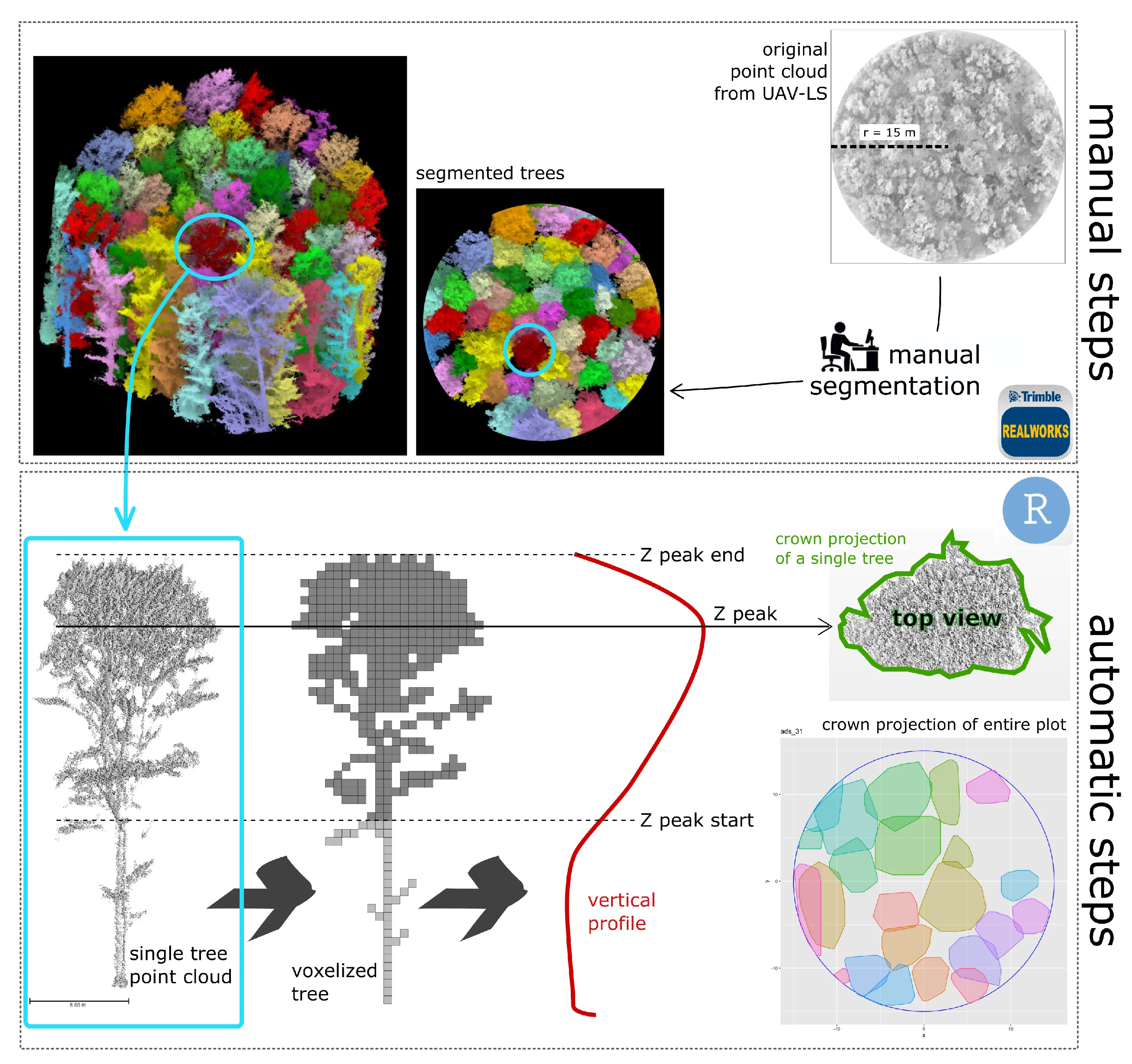
Understanding the spatial heterogeneity of forest structure is crucial for comprehending ecosystem dynamics and promoting sustainable forest management. Unmanned aerial vehicle (UAV) LiDAR technology provides a promising method to capture detailed three-dimensional (3D) information about forest canopies, aiding in management and silvicultural practices. This study investigates the heterogeneity of forest structure in broadleaf forests using UAV LiDAR data, with a particular focus on tree crown features and their different information content compared to diameters. We explored a non-conventionally used method that emphasizes crown competition by employing a nearest neighbor selection technique based on metrics derived from UAV point cloud profiles at the tree level, rather than traditional DBH (diameter at breast height) spatial arrangement. About 300 vegetation elements within 10 plots collected in a managed Beech forest were used as reference data. We demonstrate that crown-based approaches, which are feasible with UAV LiDAR data at a reasonable cost and time, significantly enhances the understanding of forest heterogeneity, adding new information content for managers. Our findings underscore the utility of UAV LiDAR in characterizing the complexity and variability of forest structure at high resolution, offering valuable insights for carbon accounting and sustainable forest management. © 2024 by the authors.

LAIr: an R package to estimate LAI from Normalized Difference Vegetation Index
Bajocco
,
Sofia
,
Ferrara
,
Carlotta
,
Savian
,
Francesco
,
Ginaldi
,
Fabrizio
,
Puletti
,
Nicola
,
Crecco
,
Lorenzo
,
Bregaglio
,
Simone Ugo Maria
,
Chianucci
,
Francesco
Mostra abstract
Leaf area index (LAI) is an important biophysical parameter describing vegetation. LAI is typically retrieved from optical remote sensing by empirical models relating LAI to vegetation indices, such as the Normalized Difference Vegetation Index (NDVI). As the relationship between LAI and NDVI is non-linear and crop type dependant, several specific empirical equations relating LAI to NDVI have been developed using field data. This study presented LAIr, an R package to derive LAI from NDVI data from the most comprehensive library of conversion equations. In the package, the range of functions differs on environmental factors, sensors, and vegetation types, allowing flexibility in choosing appropriate options based on specific application, scale of investigation and data availability. We illustrated the use of the package with a case study to compare a generic LAI product with specific NDVI-based LAI estimations. By leveraging empirical knowledge, LAIr enables accurate and context-specific estimation of LAI. The deployment of an open-source R package serves as a valuable tool for aiding researchers in selecting the most appropriate equations for conducting NDVI-to-LAI conversion. © 2024
From model selection to maps: A completely design-based data-driven inference for mapping forest resources
Di Biase
,
Rosa Maria
,
Fattorini
,
Lorenzo
,
Franceschi
,
Sara
,
Grotti
,
Mirko
,
Puletti
,
Nicola
,
Corona
,
P.
density estimation
harmonization
model selection
predictions
pseudopopulation bootstrap
regression estimator
residuals
smoothing parameter
spatial interpolation
Mostra abstract
A completely data-driven, design-based sampling strategy is proposed for mapping a forest attribute within the spatial units tessellating a survey region. Based on sample data, a model is selected, and model parameters are estimated using least-squares criteria for predicting the attribute of interest within units as a linear function of a set of auxiliary variables. The spatial interpolation of residuals arising from model predictions is performed by inverse distance weighting. The leave-one-out cross validation procedure is adopted for selecting the smoothing parameter used for interpolation. The densities of the attributes of interest within units are estimated by summing predictions and interpolated residuals. Finally, density estimates are rescaled to match the total estimate over the survey region obtained by the traditional regression estimator with the total estimate obtained from the map as the sum of the density estimates within units. A bootstrap procedure accounts for the uncertainty. The consistency of the strategy is proven by incorporating previous results. A simulation study is performed and an application for mapping wood volume densities in the forest estate of Rincine (Central Italy) is described. © 2022 John Wiley & Sons Ltd.
Probabilistic sampling and estimation for large-scale assessment of poplar plantations in Northern Italy
Corona
,
P.
,
Chianucci
,
Francesco
,
Marcelli
,
Agnese
,
Gianelle
,
Damiano
,
Fattorini
,
Lorenzo
,
Grotti
,
Mirko
,
Puletti
,
Nicola
,
Mattioli
,
Walter
Mostra abstract
In the recent decades, growing demand for wood products, combined with efforts to conserve natural forests, has supported a steady increase in the global extent of planted forests. In this paper, a two-phase sampling strategy for large-scale assessment of hybrid poplar plantations in Northern Italy was implemented. The first phase was performed by means of tessellation stratified sampling on high-resolution remotely sensed imagery, covering the survey area by a grid of regular polygons of equal size and randomly and independently selecting one point per quadrat. All the plantations spotted by at least one sample point were selected. In the second phase, we randomly chosen a subset of plantations by stratified sampling that were visited on the ground to collect qualitative and quantitative attributes. The resulting estimates were reliable, and the survey demonstrated relatively easy to be implemented and replicated. These considerations support the use of the proposed sampling strategy to frequently update information on fast-growing forest plantations within agricultural farms, like hybrid poplar crops. Moreover, the results of the case study here presented highlight the relevance of hybrid poplar plantations in Italy, in the context of sustainable development strategies under a green economy perspective. © 2020, Springer-Verlag GmbH Germany, part of Springer Nature.
Large-scale two-phase estimation of wood production by poplar plantations exploiting sentinel-2 data as auxiliary information
Marcelli
,
Agnese
,
Mattioli
,
Walter
,
Puletti
,
Nicola
,
Chianucci
,
Francesco
,
Gianelle
,
Damiano
,
Grotti
,
Mirko
,
Chirici
,
Gherardo
,
D'Amico
,
Giovanni
,
Francini
,
Saverio
,
Travaglini
,
Davide
,
Fattorini
,
Lorenzo
,
Corona
,
P.
national forest inventories
regression estimator
sentinel-2
design-based inference
first-phase tessellation stratified sampling
second-phase stratified sampling
simulation study
Mostra abstract
Growing demand for wood products, combined with efforts to conserve natural forests, have supported a steady increase in the global extent of planted forests. Here, a two-phase sampling strategy for large-scale assessment of the total area and the total wood volume of fast-growing forest tree crops within agricultural land is presented. The first phase is performed using tessellation stratified sampling on high-resolution remotely sensed imagery and is sufficient for estimating the total area of plantations by means of a Monte Carlo integration estimator. The second phase is performed using stratified sampling of the plantations selected in the first phase and is aimed at estimating total wood volume by means of an approximation of the first-phase Horvitz-Thompson estimator. Vegetation indices from Sentinel-2 are exploited as freely available auxiliary information in a linear regression estimator to improve the design-based precision of the estimator based on the sole sample data. Estimators of the totals and of the design-based variances of total estimators are presented. A simulation study is developed in order to check the design-based performance of the two alternative estimators under several artificial distributions supposed for poplar plantations (random, clustered, spatially trended). An application in Northern Italy is also reported. The regression estimator turns out to be invariably better than that based on the sole sample information. Possible integrations of the proposed sampling scheme with conventional national forest inventories adopting tessellation stratified sampling in the first phase are discussed. © 2020, Finnish Society of Forest Science. All rights reserved.
Estimating tree diversity in forest ecosystems by two-phase inventories
Corona
,
P.
,
Fattorini
,
Lorenzo
,
Franceschi
,
Sara
,
Marcheselli
,
Marzia
,
Pisani
,
Caterina
,
Chiavetta
,
U.
,
Puletti
,
Nicola
Mostra abstract
Several studies reveal that there is a strong interconnection between climate change and biodiversity. Indeed, estimating plant biodiversity is an important issue under forest ecosystem monitoring, which allows the evaluation of carbon storage and sequestration capacity. To this end, a two-phase strategy, suitably compatible with the most adopted sampling designs in large-scale forest inventories, is proposed. In the first phase, tessellation stratified sampling is performed by partitioning the study area into a grid of quadrats and by randomly selecting a point in each quadrat. The first-phase points are classified as forest or nonforest using remotely sensed imagery. In the second phase, a sample of points is selected from those classified as forest by means of simple random sampling without replacement. The second-phase points constitute the centers of circular plots that are visited in the field to record plant species (usually trees) and their abundance. Estimators of abundance and diversity and estimators of their variances are presented. The proposed strategy is applied in a forest area from Central Italy, as a case study. With respect to the sampling effort, the resulting estimates of relative standard errors are satisfactory, especially those regarding the overall total and diversity index estimators. The proposed statistical approach represents a suitable reference for integrated forest inventory frameworks effectively supporting biodiversity monitoring and assessment. © 2018 John Wiley & Sons, Ltd.
Inference on forest attributes and ecological diversity of trees outside forest by a two-phase inventory
Marchetti
,
Marco
,
Garfì
,
Vittorio
,
Pisani
,
Caterina
,
Franceschi
,
Sara
,
Marcheselli
,
Marzia
,
Corona
,
P.
,
Puletti
,
Nicola
,
Vizzarri
,
Matteo
,
Di Cristofaro
,
Marco
,
Ottaviano
,
Marco
,
Fattorini
,
Lorenzo
Mostra abstract
Key message: Trees outside forests (TOF) have crucial ecological and social-economic roles in rural and urban contexts around the world. We demonstrate that a large-scale estimation strategy, based on a two-phase inventory approach, effectively supports the assessment of TOF’s diversity and related climate change mitigation potential. Context: Although trees outside forest (TOF) affect the ecological quality and contribute to increase the social and economic developments at various scales, lack of data and difficulties to harmonize the known information currently limit their integration into national and global forest inventories. Aims: This study aims to develop and test a large-scale estimation framework to assess ecological diversity and above-ground carbon stock of TOF. Methods: This study adopts a two-phase inventory approach. Results: In the surveyed territory (Molise region, Central Italy), all the attributes considered (tree abundance, basal area, wood volume, above-ground carbon stock) are concentrated in a few dominant species. Furthermore, carbon stock in TOF above-ground biomass is non-negligible (on average: 28.6 t ha<sup>−1</sup>). Compared with the low field sampling effort (0.08% out of 52,796 TOF elements), resulting uncertainty of the estimators are more than satisfactory, especially those regarding the diversity index estimators (relative standard errors < 10%). Conclusion: The proposed approach can be suitably applied on vast territories to support landscape planning and maximize ecosystem services balance from TOF. © 2018, INRA and Springer-Verlag France SAS, part of Springer Nature.
Checking the performance of point and plot sampling on aerial photoimagery of a large-scale population of trees outside forests
Fattorini
,
Lorenzo
,
Puletti
,
Nicola
,
Chirici
,
Gherardo
,
Corona
,
P.
,
Gazzarri
,
C.
,
Mura
,
Matteo
,
Marchetti
,
Marco
tessellation stratified sampling
two-phase sampling
design-based estimation
one-per-stratum stratified sampling
Mostra abstract
The present study investigates some sampling strategies for the estimation of abundance and canopy cover of trees outside forest (TOF) over large areas. A collection of about 53 000 TOF units in Central Italy was acquired by visual, on-screen interpretation of aerial orthophotos and was taken as the reference population with the purpose of investigating: (i) one-phase inventories with sample points located by means of the tessellation stratified sampling (TSS), which involves covering the study region by a grid of regular polygons of equal sizes and randomly and independently selecting a point in each of them; (ii) two-phase inventories with the one-per-stratum stratified sampling adopted in the second phase to select a sample of polygons from the grid and then visit only the points contained in those polygons. Uniform random sampling is also considered in the first phase as a benchmark for tessellation stratified sampling. The sampling schemes adopted to select TOF units at the sample points are as follows: (i) point sampling, (ii) centroid-based plot sampling with plot radius of 50m(CPLS50) or 100 m, and (iii) plot intersect sampling with plot radius of 50 or 100 m. CPLS50 under single-phase TSS proves to be a promising strategy to large-scale TOF inventories. © 2016, Canadian Science Publishing. All rights reserved.
Sustainable forest planning: Assessing biodiversity effects of Triad zoning based on empirical data and virtual landscapes
Duflot
,
Rémi
,
Heinrichs
,
Steffi
,
Balducci
,
Lorenzo
,
Chianucci
,
Francesco
,
Hofmeister
,
Jeňýk
,
Paillet
,
Yoan
,
Trentanovi
,
Giovanni
,
Archaux
,
Frédéric
,
Boch
,
Steffen
,
Bouget
,
Christophe
,
Dvořák
,
Daniel
,
Fischer
,
Markus
,
Gosselin
,
Frédéric
,
Gosselin
,
Marion
,
Goßner
,
Martin M.
,
Holá
,
Eva
,
Hošek
,
Jan
,
Jung
,
Kirsten G.
,
Palice
,
Zdeněk
,
Renner
,
Swen C.
,
Weisser
,
Wolfgang W.
,
Nagel
,
Thomas A.
,
Burrascano
,
Sabina
,
Schall
,
Peter
Mostra abstract
The Triad framework seeks to balance the economic and ecological functions in forested landscapes by combining intensively, extensively, and unmanaged areas, assuming a higher support to biodiversity in extensively rather than in intensively managed forests. We quantified the effects of Triad zoning on biodiversity in (sub)montane eutrophic European beech forests. Using a European-wide multitaxon database and a “virtual” landscape approach (i.e., by resampling empirical data), we evaluated how the proportion of Triad management categories affected the landscape-level species diversity of birds, saproxylic beetles, vascular plants, epiphytic bryophytes, lichens, and wood-inhabiting fungi, as well as multitaxonomic diversity. The results varied greatly among taxonomic groups. Multitaxonomic diversity peaked in landscapes composed of 60% unmanaged and 40% intensively managed forests. While intensive management can benefit some taxa through the creation of open habitats, unmanaged forests are the backbone of biodiversity conservation, underlining the need to safeguard the remaining old-growth forests under natural dynamics, and to extend the current area of unmanaged forests in Europe. Extensive forest management, however, did not contribute to biodiversity conservation as expected. As withdrawing such a high proportion of European forest landscapes from management is unfeasible given the increasing demand for timber, efforts are needed to increase the presence of structural features supporting biodiversity into extensively managed forests. © © 2025 the Author(s).
Managed forests are a stronghold of non-native beetles in Europe
Basile
,
Marco
,
Lachat
,
Thibault
,
Balducci
,
Lorenzo
,
Chianucci
,
Francesco
,
Chojnacki
,
Lucas
,
Archaux
,
Frédéric
,
N Avtzis
,
Dimitrios N.
,
Bouget
,
Christophe
,
de Smedt
,
Pallieter
,
Doerfler
,
Inken
,
Dumas
,
Yann
,
Elek
,
Zoltán
,
Gosselin
,
Marion
,
Goßner
,
Martin M.
,
Heilmann-Clausen
,
Jacob
,
Hofmeister
,
Jeňýk
,
Hošek
,
Jan
,
Janssen
,
Philippe
,
Justesen
,
Mathias Just
,
Hansen
,
Aslak Kappel
,
Schmidt
,
Inger Kappel
,
Kepfer-Rojas
,
Sebastian
,
Mårell
,
Anders
,
Matula
,
Radim
,
Müller
,
Jörg C. C.
,
Nordén
,
Björn
,
Ódor
,
Péter
,
Paillet
,
Yoan
,
Ravera
,
Sonia
,
Sitzia
,
Tommaso
,
Tinya
,
Flóra
,
Burrascano
,
Sabina
,
Brockerhoff
,
Eckehard G.
Mostra abstract
The species richness of vascular plants in forests can have contrasting effects on the occurrence of non-native insects. The establishment of non-native insect populations may be facilitated by low plant species richness, which reflects the availability of few but easily accessible resources, or hampered by high plant species richness due to spatial dilution of resources or biotic resistance (i.e., resistance against biological invasions). The relationship between the species richness of plants and non-native insects is likely influenced by disturbance regimes, which, in European forests, mostly consists of timber harvesting. We investigated this relationship considering two major forest attributes: (i) species richness of non-native vascular plants and (ii) forest management. From 1101 forest plots in Europe, we gathered occurrences of 1212 vascular plant species, including 160 non-native species, and of 2404 beetle species, including 29 non-native species. We tested the relationship between the species richness of non-native beetles and plants using non-linear quantile regressions. We disentangled the effect of non-native plant species richness from that of management on the species richness of non-native beetles, while accounting for forest structural variables, using structural equation models. We found clear evidence of a hump-shaped relationship between non-native beetle and plant species richness. The general shape of the relationship persisted when considering only woody or non-woody plants, as well as only non-native plants. The relationship was also similar between managed and unmanaged forests. However, the proportion of non-native beetles in managed forests was higher than in unmanaged forests at the same plant species richness. Management had a direct negative effect on non-native beetle species richness, whereas non-native plant species richness had a direct positive effect. When considering all direct and indirect effects, management facilitated the occurrence of non-native beetles indirectly via non-native plants rather than directly. Synthesis and applications. Species richness of native and non-native vascular plants modulates the species richness of non-native beetles through relationships with opposite signs. The interplay with management regimes and forest structures determines whether non-native beetles are promoted. Forest management aimed at reducing the intensity of disturbance while encouraging native plant species richness could promote the dominance of dilution effects and biotic resistance and could moderate the establishment of non-native insects. © 2025 The Author(s). Journal of Applied Ecology © 2025 British Ecological Society.
Towards an effective in-situ biodiversity assessment in European forests
Burrascano
,
Sabina
,
Chojnacki
,
Lucas
,
Balducci
,
Lorenzo
,
Chianucci
,
Francesco
,
Haeler
,
Elena
,
Kepfer-Rojas
,
Sebastian
,
Paillet
,
Yoan
,
de Andrade
,
Rafael Barreto
,
Boch
,
Steffen
,
de Smedt
,
Pallieter
,
Fischer
,
Markus
,
Mijangos
,
Itziar Garcia
,
Heilmann-Clausen
,
Jacob
,
Hofmeister
,
Jeňýk
,
Hošek
,
Jan
,
Kozák
,
Daniel
,
Kutszegi
,
Gergely
,
Lachat
,
Thibault
,
Mikoláš
,
Martin
,
Samu
,
Ferenc
,
Ravera
,
Sonia
,
Schall
,
Peter
,
Sitzia
,
Tommaso
,
Svoboda
,
Miroslav
,
Trentanovi
,
Giovanni
,
Ujházyová
,
Mariana
,
Vandekerkhove
,
Kris
,
Tinya
,
Flóra
,
Ódor
,
Péter
forest biodiversity
vascular plants
birds
epiphytic bryophytes
epiphytic lichens
monitoring network
multivariate standard error
rarefaction curves
saproxylic beetles
wood-inhabiting fungi
Mostra abstract
Assessing multi-taxon biodiversity is crucial to understand forests’ response to environmental changes and to inform management strategies. In Europe, forest biodiversity monitoring is still scattered and heterogeneous, although a long-term monitoring network has long been advocated. Given the monitoring aims reported in various EU policies, this network should be accurately designed also through the estimation of its sampling effort, here intended as the number of sampling plots and sites. We used a novel database of forest multi-taxon biodiversity for a pilot study to: estimate the minimum sampling effort needed to: assess variation in species richness and composition; compare these estimates with the efforts invested in the pilot database; discuss estimates’ differences across taxonomic groups and forest categories. We focused on six taxonomic groups (vascular plants, birds, epiphytic lichens and bryophytes, wood-inhabiting fungi and saproxylic beetles) across six forest categories. Based on 6,165 plots at 2,084 different locations across Europe, we benchmarked the effort to achieve: a complete species richness estimate through interpolation/extrapolation curves, and a precise evaluation of species composition variation through multivariate standard error. Our estimates differed widely, especially among taxonomic groups. For species richness, estimates range from 3 to 147 plots per site across 3 to 29 sites per forest category, with birds and epiphytic bryophytes requiring the least effort. For species composition, estimates range from 5 to over 25 plots per site across 5 to 20 sites per forest category, with saproxylic beetles, vascular plants, and fungi displaying the highest estimates. The taxonomic groups requiring an effort comparable to existing data were the least diverse, all the others need greater efforts, either for species richness (e.g., saproxylic beetles), or species composition (e.g., vascular plants), or both (e.g., wood-inhabiting fungi). An effective monitoring network of European forests’ biodiversity should thoroughly account for these benchmarks and for their taxon-dependency. © 2025
One to rule them all? Assessing the performance of sustainable forest management indicators against multitaxonomic data for biodiversity conservation
Paillet
,
Yoan
,
Zapponi
,
Livia
,
Schall
,
Peter
,
Monnet
,
Jean Matthieu
,
Ammer
,
Christian
,
Balducci
,
Lorenzo
,
Boch
,
Steffen
,
Brazaitis
,
Gediminas
,
Campanaro
,
Alessandro
,
Chianucci
,
Francesco
,
Doerfler
,
Inken
,
Fischer
,
Markus
,
Gosselin
,
Marion
,
Goßner
,
Martin M.
,
Heilmann-Clausen
,
Jacob
,
Hofmeister
,
Jeňýk
,
Hošek
,
Jan
,
Jung
,
Kirsten G.
,
Kepfer-Rojas
,
Sebastian
,
Ódor
,
Péter
,
Tinya
,
Flóra
,
Trentanovi
,
Giovanni
,
Vacchiano
,
Giorgio
,
Vandekerkhove
,
Kris
,
Weisser
,
Wolfgang W.
,
Wohlwend
,
Michael Rudolf
,
Burrascano
,
Sabina
Mostra abstract
Several regional initiatives and reporting efforts assess the state of forest biodiversity through broad-scale indicators based on data from national forest inventories. Although valuable, these indicators are essentially indirect and evaluate habitat quantity and quality rather than biodiversity per se. Therefore, their link to biodiversity may be weak, which decreases their usefulness for decision-making. For several decades, Forest Europe indicators assessed the state of European forests, in particular their biodiversity. However, no extensive study has been conducted to date to assess their performance – i.e. the capacity of the indicators to reflect variations in biodiversity – against multitaxonomic data. We hypothesized that no single biodiversity indicator from Forest Europe can represent overall forest biodiversity, but that several indicators would reflect habitat quality for at least some taxa in a comprehensive way. We tested the set of Forest Europe's indicators against the species richness of six taxonomic and functional groups across several hundreds of sampling units over Europe. We showed that, while some indicators perform relatively well across groups (e.g. deadwood volume), no single indicator represented all biodiversity at once, and that a combination of several indicators performed better. Forest Europe indicators were chosen for their availability and ease of understanding for most people. However, we showed that gaps in the monitoring framework persist, and that surveying certain taxa along with stand structure is necessary to support policymaking and tackle forest biodiversity loss at the large scale. Adding context (e.g. forest type) may also contribute to increase the performance of biodiversity indicators. © 2024 Elsevier Ltd
Silvicultural regime shapes understory functional structure in European forests
Chianucci
,
Francesco
,
Napoleone
,
Francesca
,
Ricotta
,
Carlo
,
Ferrara
,
Carlotta
,
Fusaro
,
Lina
,
Balducci
,
Lorenzo
,
Trentanovi
,
Giovanni
,
Bradley
,
Owen
,
Kovács
,
Bence
,
Mina
,
Marco
,
Cerabolini
,
Bruno Enrico Leone
,
Vandekerkhove
,
Kris
,
de Smedt
,
Pallieter
,
Lens
,
Luc
,
Hertzog
,
Lionel R.
,
Verheyen
,
Kris
,
Hofmeister
,
Jeňýk
,
Hošek
,
Jan
,
Matula
,
Radim
,
Doerfler
,
Inken
,
Müller
,
Jörg C. C.
,
Weisser
,
Wolfgang W.
,
Helback
,
Jan
,
Schall
,
Peter
,
Fischer
,
Markus
,
Heilmann-Clausen
,
Jacob
,
Riis-Hansen
,
Rasmus
,
Goldberg
,
Irina
,
Aude
,
Erik
,
Kepfer-Rojas
,
Sebastian
,
Kappel Schmidt
,
Inger
,
Riis-Nielsen
,
Torben
,
Mårell
,
Anders
,
Dumas
,
Yann
,
Janssen
,
Philippe
,
Paillet
,
Yoan
,
Archaux
,
Frédéric
,
Xystrakis
,
Fotios
,
Tinya
,
Flóra
,
Ódor
,
Péter
,
Aszalós
,
Réka
,
Bölöni
,
János
,
Cutini
,
Andrea
,
Bagella
,
Simonetta
,
Sitzia
,
Tommaso
,
Brazaitis
,
Gediminas
,
Marozas
,
Vitas
,
Ujházyová
,
Mariana
,
Ujházy
,
Karol
,
Máliš
,
František
,
Nordén
,
Björn
,
Burrascano
,
Sabina
functional diversity
functional redundancy
forest understory
sustainable forest management
unmanaged forests
ecosystem resilience
silvicultural regime
Mostra abstract
Managing forests to sustain their diversity and functioning is a major challenge in a changing world. Despite the key role of understory vegetation in driving forest biodiversity, regeneration and functioning, few studies address the functional dimensions of understory vegetation response to silvicultural management. We assessed the influence of the silvicultural regimes on the functional diversity and redundancy of European forest understory. We gathered vascular plant abundance data from more than 2000 plots in European forests, each associated with one out of the five most widespread silvicultural regimes. We used generalized linear mixed models to assess the effect of different silvicultural regimes on understory functional diversity (Rao's quadratic entropy) and functional redundancy, while accounting for climate and soil conditions, and explored the reciprocal relationship between three diversity components (functional diversity, redundancy and dominance) across silvicultural regimes through a ternary diversity diagram. Intensive silvicultural regimes are associated with a decrease in functional diversity and an increase in functional redundancy, compared with unmanaged conditions. This means that although intensive management may buffer communities' functions against species or functional losses, it also limits the range of understory response to environmental changes. Policy implications. Different silvicultural regimes influence different facets of understory functional features. While unmanaged forests can be used as a reference to design silvicultural practices in compliance with biodiversity conservation targets, different silvicultural options should be balanced at landscape scale to sustain the multiple forest functions that human societies are increasingly demanding. © 2024 The Author(s). Journal of Applied Ecology published by John Wiley & Sons Ltd on behalf of British Ecological Society.
Influence of Root Reinforcement on Shallow Landslide Distribution: A Case Study in Garfagnana (Northern Tuscany, Italy)
Marzini
,
Lorenzo
,
D’Addario
,
Enrico
,
Papasidero
,
Michele Pio
,
Chianucci
,
Francesco
,
Disperati
,
L.
Mostra abstract
In this work, we evaluated the influence of root structure on shallow landslide distribution. Root density measurements were acquired in the field and the corresponding root cohesion was estimated. Data were acquired from 150 hillslope deposit trenches dug in areas either devoid or affected by shallow landslides within the Garfagnana Valley (northern Tuscany, Italy). Results highlighted a correlation between the root reinforcement and the location of measurement sites. Namely, lower root density was detected within shallow landslides, with respect to neighboring areas. Root area ratio (RAR) data allowed us to estimate root cohesion by the application of the revised version of the Wu and Waldron Model. Then, we propose a new method for the assimilation of the lateral root reinforcement into the infinite slope model and the limit equilibrium approach by introducing the equivalent root cohesion parameter. The results fall within the range of root cohesion values adopted in most of the physically based shallow landslide susceptibility models known in the literature (mean values ranging between ca. 2 and 3 kPa). Moreover, the results are in line with the scientific literature that has demonstrated the link between root mechanical properties, spatial variability of root reinforcement, and shallow landslide locations. © 2023 by the authors.
Where are we now with European forest multi-taxon biodiversity and where can we head to?
Burrascano
,
Sabina
,
Chianucci
,
Francesco
,
Trentanovi
,
Giovanni
,
Kepfer-Rojas
,
Sebastian
,
Sitzia
,
Tommaso
,
Tinya
,
Flóra
,
Doerfler
,
Inken
,
Paillet
,
Yoan
,
Nagel
,
Thomas A.
,
Mitić
,
Božena
,
Morillas
,
Lourdes
,
Munzi
,
Silvana
,
Van Der Sluis
,
Theo
,
Alterio
,
Edoardo
,
Balducci
,
Lorenzo
,
de Andrade
,
Rafael Barreto
,
Bouget
,
Christophe
,
Giordani
,
P.
,
Lachat
,
Thibault
,
Matošević
,
Dinka
,
Napoleone
,
Francesca
,
Nascimbene
,
Juri
,
Paniccia
,
Chiara
,
Roth
,
Nicolas
,
Aszalós
,
Réka
,
Brazaitis
,
Gediminas
,
Cutini
,
Andrea
,
D'Andrea
,
Ettore
,
de Smedt
,
Pallieter
,
Heilmann-Clausen
,
Jacob
,
Janssen
,
Philippe
,
Kozák
,
Daniel
,
Mårell
,
Anders
,
Mikoláš
,
Martin
,
Nordén
,
Björn
,
Matula
,
Radim
,
Schall
,
Peter
,
Svoboda
,
Miroslav
,
Ujházyová
,
Mariana
,
Vandekerkhove
,
Kris
,
Wohlwend
,
Michael Rudolf
,
Xystrakis
,
Fotios
,
Aleffi
,
Michele
,
Ammer
,
Christian
,
Archaux
,
Frédéric
,
Asbeck
,
Thomas
,
N Avtzis
,
Dimitrios N.
,
Ayasse
,
Manfred
,
Bagella
,
Simonetta
,
Balestrieri
,
Rosario
,
Barbati
,
Anna
,
Basile
,
Marco
,
Bergamini
,
Ariel
,
Bertini
,
Giada
,
Biscaccianti
,
Alessandro Bruno
,
Boch
,
Steffen
,
Bölöni
,
János
,
Bombi
,
Pierluigi
,
Boscardin
,
Yves
,
Brunialti
,
Giorgio
,
Bruun
,
Hans Henrik
,
Buscot
,
François
,
Byriel
,
David Bille
,
Campagnaro
,
Thomas
,
Campanaro
,
Alessandro
,
Chauvat
,
Matthieu
,
Ciach
,
Michał
,
Čiliak
,
Marek
,
Cistrone
,
Luca
,
Pereira
,
Joaò Manuel Cordeiro
,
Daniel
,
Rolf
,
de Cinti
,
Bruno
,
de Filippo
,
Gabriele
,
Dekoninck
,
Wouter
,
Di Salvatore
,
Umberto
,
Dumas
,
Yann
,
Elek
,
Zoltán
,
Ferretti
,
Fabrizio
,
Fotakis
,
Dimitrios G.
,
Frank
,
Tamás
,
Frey
,
Julian
,
Giancola
,
Carmen
,
Gömöryová
,
Erika
,
Gosselin
,
Marion
,
Gosselin
,
Frédéric
,
Goßner
,
Martin M.
,
Götmark
,
Frank
,
Haeler
,
Elena
,
Hansen
,
Aslak Kappel
,
Hertzog
,
Lionel R.
,
Hofmeister
,
Jeňýk
,
Hošek
,
Jan
,
Johannsen
,
Vivian Kvist
,
Justensen
,
Mathias Just
,
Korboulewsky
,
Nathalie
,
Kovács
,
Bence
,
Lakatos
,
Ferenc
,
Landivar
,
Carlos Miguel
,
Lens
,
Luc
,
Lingua
,
Emanuele
forest biodiversity
biodiversity conservation
forest stand structure
multi-taxon
sustainable management
Mostra abstract
The European biodiversity and forest strategies rely on forest sustainable management (SFM) to conserve forest biodiversity. However, current sustainability assessments hardly account for direct biodiversity indicators. We focused on forest multi-taxon biodiversity to: i) gather and map the existing information; ii) identify knowledge and research gaps; iii) discuss its research potential. We established a research network to fit data on species, standing trees, lying deadwood and sampling unit description from 34 local datasets across 3591 sampling units. A total of 8724 species were represented, with the share of common and rare species varying across taxonomic classes: some included many species with several rare ones (e.g., Insecta); others (e.g., Bryopsida) were represented by few common species. Tree-related structural attributes were sampled in a subset of sampling units (2889; 2356; 2309 and 1388 respectively for diameter, height, deadwood and microhabitats). Overall, multi-taxon studies are biased towards mature forests and may underrepresent the species related to other developmental phases. European forest compositional categories were all represented, but beech forests were over-represented as compared to thermophilous and boreal forests. Most sampling units (94%) were referred to a habitat type of conservation concern. Existing information may support European conservation and SFM strategies in: (i) methodological harmonization and coordinated monitoring; (ii) definition and testing of SFM indicators and thresholds; (iii) data-driven assessment of the effects of environmental and management drivers on multi-taxon forest biological and functional diversity, (iv) multi-scale forest monitoring integrating in-situ and remotely sensed information. © 2023 The Authors
THz water transmittance and leaf surface area: An effective nondestructive method for determining leaf water content
Pagano
,
Mario
,
Baldacci
,
Lorenzo
,
Ottomaniello
,
Andrea
,
Dato
,
Giovanbattista De
,
Chianucci
,
Francesco
,
Masini
,
Luca
,
Carelli
,
Giorgio
,
Toncelli
,
Alessandra
,
Storchi
,
Paolo
,
Tredicucci
,
Alessandro
,
Corona
,
P.
Mostra abstract
Water availability is a major limiting factor in plant productivity and plays a key role in plant species distribution over a given area. New technologies, such as terahertz quantum cascade lasers (THz‐QCLs) have proven to be non‐invasive, effective, and accurate tools for measuring and monitoring leaf water content. This study explores the feasibility of using an advanced THz-QCL device for measuring the absolute leaf water content in Corylus avellana L., Laurus nobilis L., Ostrya carpinifolia Scop., Quercus ilex L., Quercus suber L., and Vitis vinifera L. (cv. Sangiovese). A recently proposed, simple spectroscopic technique was used, consisting in determining the transmission of the THz light beam through the leaf combined with a photographic measurement of the leaf area. A significant correlation was found between the product of the leaf optical depth (τ) and the leaf surface area (LA) with the leaf water mass (Mw) for all the studied species (Pearson’s r test, p ≤ 0.05). In all cases, the best fit regression line, in the graphs of τLA as a function of Mw, displayed R2 values always greater than 0.85. The method proposed can be combined with water stress indices of plants in order to gain a better understanding of the leaf water management processes or to indirectly monitor the kinetics of leaf invasion by pathogenic bacteria, possibly leading to the development of specific models to study and fight them. © 2019 by the authors. Licensee MDPI, Basel, Switzerland.