Loading...
Pubblicazioni Scientifiche
Filtri di ricerca 4 risultati
Pubblicazioni per anno
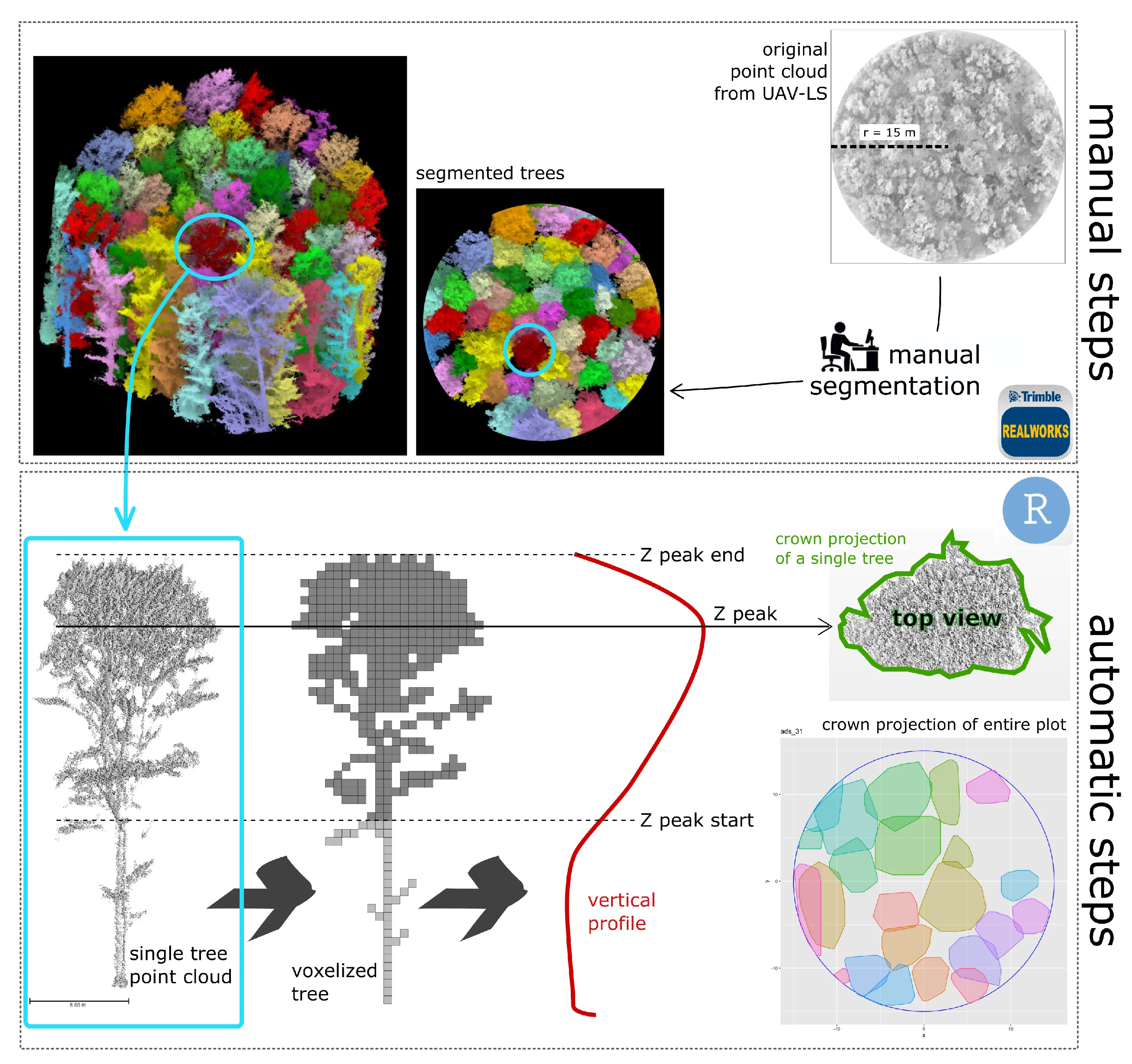
A Semi-Automatic Approach for Tree Crown Competition Indices Assessment from UAV LiDAR
beech forests
individual tree segmentation
precision forestry
size differation index
vertical profile traits
Mostra abstract
Understanding the spatial heterogeneity of forest structure is crucial for comprehending ecosystem dynamics and promoting sustainable forest management. Unmanned aerial vehicle (UAV) LiDAR technology provides a promising method to capture detailed three-dimensional (3D) information about forest canopies, aiding in management and silvicultural practices. This study investigates the heterogeneity of forest structure in broadleaf forests using UAV LiDAR data, with a particular focus on tree crown features and their different information content compared to diameters. We explored a non-conventionally used method that emphasizes crown competition by employing a nearest neighbor selection technique based on metrics derived from UAV point cloud profiles at the tree level, rather than traditional DBH (diameter at breast height) spatial arrangement. About 300 vegetation elements within 10 plots collected in a managed Beech forest were used as reference data. We demonstrate that crown-based approaches, which are feasible with UAV LiDAR data at a reasonable cost and time, significantly enhances the understanding of forest heterogeneity, adding new information content for managers. Our findings underscore the utility of UAV LiDAR in characterizing the complexity and variability of forest structure at high resolution, offering valuable insights for carbon accounting and sustainable forest management. © 2024 by the authors.

Assessment of UAV photogrammetric DTM-independent variables for modelling and mapping forest structural indices in mixed temperate forests
Giannetti
,
Francesca
,
Puletti
,
Nicola
,
Puliti
,
Stefano
,
Travaglini
,
Davide
,
Chirici
,
Gherardo
biodiversity
precision forestry
forest structure
forest inventory
airborne laser scanning
drone
dtm-independent
structure from motion
Mostra abstract
In the EU 2020 biodiversity strategy, maintaining and enhancing forest biodiversity is essential. Forest managers and technicians should include biodiversity monitoring as support for sustainible forest management and conservation issues, through the adoption of forest biodiversity indices. The present study investigates the potential of a new type of Structure from Motion (SfM) photogrammetry derived variables for modelling forest structure indicies, which do not require the availability of a digital terrain model (DTM) such as those obtainable from Airborne Laser Scanning (ALS) surveys. The DTM-independent variables were calculated using raw 3D UAV photogrammetric data for modeling eight forest structure indices which are commonly used for forest biodiversity monitoring, namely: basal area (G); quadratic mean diameter (DBH<inf>mean</inf>); the standard deviation of Diameter at Breast Height (DBH<inf>σ</inf>); DBH Gini coefficient (Gini); the standard deviation of tree heights (H<inf>σ</inf>); dominant tree height (H<inf>dom</inf>); Lorey's height (H<inf>l</inf>); and growing stock volume (V). The study included two mixed temperate forests areas with a different type of management, with one area, left unmanaged for the past 50 years while the other being actively managed. A total of 30 field sample plots were measured in the unmanaged forest, and 50 field plots were measured in the actively managed forest. The accuracy of UAV DTM-independent predictions was compared with a benchmark approach based on traditional explanatory variables calculated from ALS data. Finally, DTM-independent variables were used to produce wall-to-wall maps of the forest structure indices in the two test areas and to estimate the mean value and its uncertainty according to a model-assisted regression estimators. DTM-independent variables led to similar predictive accuracy in terms of root mean square error compared to ALS in both study areas for the eight structure indices (DTM-independent average RMSE<inf>%</inf> = 20.5 and ALS average RMSE<inf>%</inf> = 19.8). Moreover, we found that the model-assisted estimation, with both DTM-independet and ALS, obtained lower standar errors (SE) compared to the one obtained by model-based estimation using only field plots. Relative efficiency coefficient (RE) revealed that ALS-based estimates were, on average, more efficient (average RE ALS = 3.7) than DTM-independent, (average RE DTM-independent = 3.3). However, the RE for the DTM-independent models was consistently larger than the one from the ALS models for the DBH-related variables (i.e. G, DBH<inf>mean</inf>, and DBH<inf>σ</inf>) and for V. This highlights the potential of DTM-independent variables, which not only can be used virtually on any forests (i.e., no need of a DTM), but also can produce as precise estimates as those from ALS data for key forest structural variables and substantially improve the efficiency of forest inventories. © 2020 Elsevier Ltd
Integrating terrestrial and airborne laser scanning for the assessment of single-tree attributes in Mediterranean forest stands
Giannetti
,
Francesca
,
Puletti
,
Nicola
,
Quatrini
,
Valerio
,
Travaglini
,
Davide
,
Bottalico
,
Francesca
,
Corona
,
P.
,
Chirici
,
Gherardo
Mostra abstract
The development of laser scanning technologies has gradually modified methods for forest mensuration and inventory. The main objective of this study is to assess the potential of integrating ALS and TLS data in a complex mixed Mediterranean forest for assessing a set of five single-tree attributes: tree position (TP), stem diameter at breast height (DBH), tree height (TH), crown base height (CBH) and crown projection area radii (CPAR). Four different point clouds were used: from ZEB1, a hand-held mobile laser scanner (HMLS), and from FARO® FOCUS 3D, a static terrestrial laser scanner (TLS), both alone or in combination with ALS. The precision of single-tree predictions, in terms of bias and root mean square error, was evaluated against data recorded manually in the field with traditional instruments. We found that: (i) TLS and HMLS have excellent comparable performances for the estimation of TP, DBH and CPAR; (ii) TH was correctly assessed by TLS, while the accuracy by HMLS was lower; (iii) CBH was the most difficult attribute to be reliably assessed and (iv) the integration with ALS increased the performance of the assessment of TH and CPAR with both HMLS and TLS. © 2018, © 2018 The Author(s). Published by Informa UK Limited, trading as Taylor & Francis Group.
Dataset of tree inventory and canopy structure in poplar plantations in Northern Italy
Chianucci
,
Francesco
,
Marchino
,
Luca
,
Bidini
,
Claudio
,
Giorcelli
,
Achille
,
Coaloa
,
Domenico
,
Chiarabaglio
,
Pier Mario
,
Giannetti
,
Francesca
,
Chirici
,
Gherardo
,
Tattoni
,
Clara
Mostra abstract
The dataset reports data collected in 38 square (50 x 50m) 0.25 ha plots representative of poplar plantations in Lombardy Region (Northern Italy), which were used to calibrate optical information derived from unmanned aerial vehicle (UAV) and satellite (Sentinel-2) sensors. In each plot, the diameter at breast height was measured using a caliper; height, stem and crown volume of each tree were then derived from diameter using allometric equations developed in an independent study. Additional canopy attributes (foliage and crown cover, crown porosity, leaf area index) were derived in each plot from 12-20 optical images collected using digital cover photography (DCP). The collected data allows characterizing the assessment of structure of these plantations, along with their variation over the rotation time. Canopy and crown data also enable the evaluation of optimal rotation and tree spacing, as well as the relationship between stand and canopy structure. The raw datasets consist of 2,591 records (trees) associated with inventory measurements and 616 records (images) associated with optical canopy measurements. An R code was also provided to calculate plot-level attributes from raw data. Dataset and associated metadata are freely available at http://dx.doi.org/10.17632/ycr7w5pvkt.1. © 2021 Centro di Ricerca per la Selvicoltura, Consiglio per la Ricerca in Agricoltura e l'Analisi dell'Economia Agraria. All rights reserved.