Loading...
Pubblicazioni Scientifiche
Filtri di ricerca 5 risultati
Pubblicazioni per anno
A Semi-Automatic Approach for Tree Crown Competition Indices Assessment from UAV LiDAR
beech forests
individual tree segmentation
precision forestry
size differation index
vertical profile traits
Mostra abstract
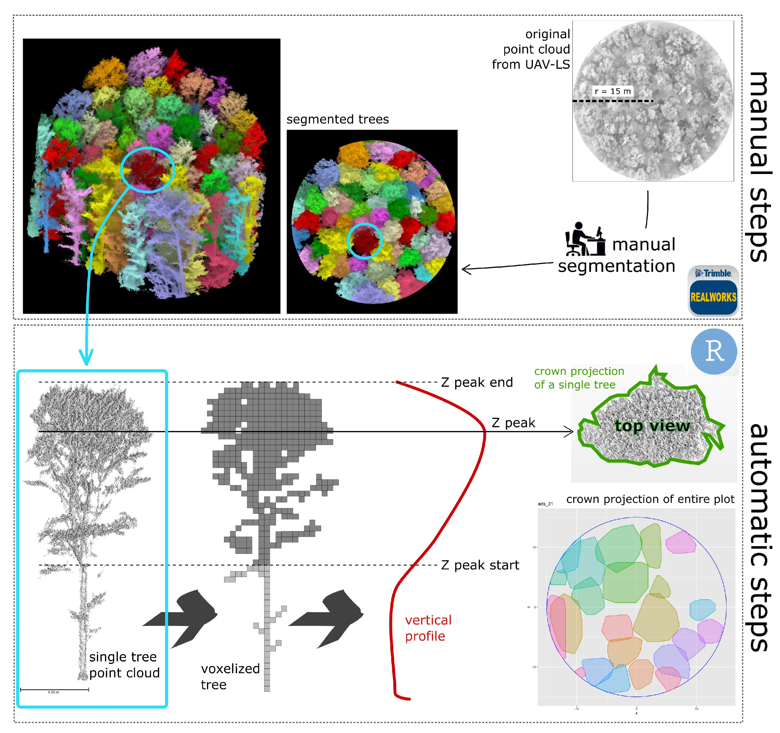
Understanding the spatial heterogeneity of forest structure is crucial for comprehending ecosystem dynamics and promoting sustainable forest management. Unmanned aerial vehicle (UAV) LiDAR technology provides a promising method to capture detailed three-dimensional (3D) information about forest canopies, aiding in management and silvicultural practices. This study investigates the heterogeneity of forest structure in broadleaf forests using UAV LiDAR data, with a particular focus on tree crown features and their different information content compared to diameters. We explored a non-conventionally used method that emphasizes crown competition by employing a nearest neighbor selection technique based on metrics derived from UAV point cloud profiles at the tree level, rather than traditional DBH (diameter at breast height) spatial arrangement. About 300 vegetation elements within 10 plots collected in a managed Beech forest were used as reference data. We demonstrate that crown-based approaches, which are feasible with UAV LiDAR data at a reasonable cost and time, significantly enhances the understanding of forest heterogeneity, adding new information content for managers. Our findings underscore the utility of UAV LiDAR in characterizing the complexity and variability of forest structure at high resolution, offering valuable insights for carbon accounting and sustainable forest management. © 2024 by the authors.

LAIr: an R package to estimate LAI from Normalized Difference Vegetation Index
Bajocco
,
Sofia
,
Ferrara
,
Carlotta
,
Savian
,
Francesco
,
Ginaldi
,
Fabrizio
,
Puletti
,
Nicola
,
Crecco
,
Lorenzo
,
Bregaglio
,
Simone Ugo Maria
,
Chianucci
,
Francesco
Mostra abstract
Leaf area index (LAI) is an important biophysical parameter describing vegetation. LAI is typically retrieved from optical remote sensing by empirical models relating LAI to vegetation indices, such as the Normalized Difference Vegetation Index (NDVI). As the relationship between LAI and NDVI is non-linear and crop type dependant, several specific empirical equations relating LAI to NDVI have been developed using field data. This study presented LAIr, an R package to derive LAI from NDVI data from the most comprehensive library of conversion equations. In the package, the range of functions differs on environmental factors, sensors, and vegetation types, allowing flexibility in choosing appropriate options based on specific application, scale of investigation and data availability. We illustrated the use of the package with a case study to compare a generic LAI product with specific NDVI-based LAI estimations. By leveraging empirical knowledge, LAIr enables accurate and context-specific estimation of LAI. The deployment of an open-source R package serves as a valuable tool for aiding researchers in selecting the most appropriate equations for conducting NDVI-to-LAI conversion. © 2024
Moths in space: The below-canopy structure of forest drives abundance and mobility-related traits of moth communities
La Cava
,
Sara
,
Rijllo
,
Giuseppe
,
Zucco
,
Giada
,
Innocenti
,
Simone
,
Guasti
,
Matteo
,
Puletti
,
Nicola
,
Ferrara
,
Carlotta
,
Scalercio
,
S.
Mostra abstract
The distribution of species is primarily driven by the availability of trophic resources. In a given forest type, insects trophically related to the dominant tree are expected to be evenly distributed due to the abundance of their foodplant. However, their distribution is also influenced by complex relationships with abiotic and biotic parameters such as available space, predatory pressure, and morphometric traits. In this study, we investigated how the three-dimensional structure of space below the canopy may affect the composition of nocturnal lepidoptera communities. To synthesise the complexity of the dispersal behaviour of these insects, we evaluated easily measurable traits such as wingspan and the presence of tympanic organs, both connected to their mobility and thus potentially influenced by the structure of the available flight space. The study was conducted in the Sila National Park (Italy), where 12 sampling sites were selected in pine forests and an additional 12 in beech forests. Forest spatial structure was investigated using a portable terrestrial laser scanner. Moths were sampled monthly using light traps from May to October in both 2019 and 2020. Among measured forest traits, we observed that the space above three meters from the ground is the only factor influencing community composition. Larger species with tympanic organs prefer environments with less space below tree canopies. Our findings could be the starting point for future studies that investigate a potential defence strategy of moths against bats, as tympanate and larger species not only actively avoid chiropter predation but could also choose denser forests because of a lower bat activity. Moths' distribution and community composition thus appear to be significantly shaped by the spatial structure of forests. © 2024 Elsevier B.V.
A co-registration approach between terrestrial and UAV laser scanning point clouds based on ground and trees features
Mostra abstract
Accurate co-registration of terrestrial and aerial point clouds can provide a high-resolution description of tree components across large forest areas. However, a semi-automatic approach for co-registering point clouds is still needed, given the challenges in geospatial data processing, particularly in complex topographical conditions. The main objective of this study is to present the application of a novel procedure for the co-registration of point clouds obtained from terrestrial and UAV surveys in Mediterranean forests. The proposed methodology proves to be promising and will constitute the basis for experimentation on a larger scale. © 2024 Istituto Sperimentale per la Selvicoltura. All rights reserved.
Silvicultural regime shapes understory functional structure in European forests
Chianucci
,
Francesco
,
Napoleone
,
Francesca
,
Ricotta
,
Carlo
,
Ferrara
,
Carlotta
,
Fusaro
,
Lina
,
Balducci
,
Lorenzo
,
Trentanovi
,
Giovanni
,
Bradley
,
Owen
,
Kovács
,
Bence
,
Mina
,
Marco
,
Cerabolini
,
Bruno Enrico Leone
,
Vandekerkhove
,
Kris
,
de Smedt
,
Pallieter
,
Lens
,
Luc
,
Hertzog
,
Lionel R.
,
Verheyen
,
Kris
,
Hofmeister
,
Jeňýk
,
Hošek
,
Jan
,
Matula
,
Radim
,
Doerfler
,
Inken
,
Müller
,
Jörg C. C.
,
Weisser
,
Wolfgang W.
,
Helback
,
Jan
,
Schall
,
Peter
,
Fischer
,
Markus
,
Heilmann-Clausen
,
Jacob
,
Riis-Hansen
,
Rasmus
,
Goldberg
,
Irina
,
Aude
,
Erik
,
Kepfer-Rojas
,
Sebastian
,
Kappel Schmidt
,
Inger
,
Riis-Nielsen
,
Torben
,
Mårell
,
Anders
,
Dumas
,
Yann
,
Janssen
,
Philippe
,
Paillet
,
Yoan
,
Archaux
,
Frédéric
,
Xystrakis
,
Fotios
,
Tinya
,
Flóra
,
Ódor
,
Péter
,
Aszalós
,
Réka
,
Bölöni
,
János
,
Cutini
,
Andrea
,
Bagella
,
Simonetta
,
Sitzia
,
Tommaso
,
Brazaitis
,
Gediminas
,
Marozas
,
Vitas
,
Ujházyová
,
Mariana
,
Ujházy
,
Karol
,
Máliš
,
František
,
Nordén
,
Björn
,
Burrascano
,
Sabina
functional diversity
functional redundancy
forest understory
sustainable forest management
unmanaged forests
ecosystem resilience
silvicultural regime
Mostra abstract
Managing forests to sustain their diversity and functioning is a major challenge in a changing world. Despite the key role of understory vegetation in driving forest biodiversity, regeneration and functioning, few studies address the functional dimensions of understory vegetation response to silvicultural management. We assessed the influence of the silvicultural regimes on the functional diversity and redundancy of European forest understory. We gathered vascular plant abundance data from more than 2000 plots in European forests, each associated with one out of the five most widespread silvicultural regimes. We used generalized linear mixed models to assess the effect of different silvicultural regimes on understory functional diversity (Rao's quadratic entropy) and functional redundancy, while accounting for climate and soil conditions, and explored the reciprocal relationship between three diversity components (functional diversity, redundancy and dominance) across silvicultural regimes through a ternary diversity diagram. Intensive silvicultural regimes are associated with a decrease in functional diversity and an increase in functional redundancy, compared with unmanaged conditions. This means that although intensive management may buffer communities' functions against species or functional losses, it also limits the range of understory response to environmental changes. Policy implications. Different silvicultural regimes influence different facets of understory functional features. While unmanaged forests can be used as a reference to design silvicultural practices in compliance with biodiversity conservation targets, different silvicultural options should be balanced at landscape scale to sustain the multiple forest functions that human societies are increasingly demanding. © 2024 The Author(s). Journal of Applied Ecology published by John Wiley & Sons Ltd on behalf of British Ecological Society.